
Frogmore, New South Wales facts for kids
Quick facts for kids FrogmoreNew South Wales |
|||||||||||||||
|---|---|---|---|---|---|---|---|---|---|---|---|---|---|---|---|

Frogmore
Location in New South Wales
|
|||||||||||||||
| Postcode(s) | 2586 | ||||||||||||||
| Elevation | 513 m (1,683 ft) | ||||||||||||||
| Location | |||||||||||||||
| LGA(s) | Hilltops Council | ||||||||||||||
| County | King | ||||||||||||||
| State electorate(s) | Goulburn | ||||||||||||||
| Federal Division(s) | Hume | ||||||||||||||
|
|||||||||||||||
|
|||||||||||||||
| Footnotes | Coordinates, rainfall, localities | ||||||||||||||
Frogmore is a small village in New South Wales, Australia. It is located in an area called the Southern Tablelands. Long ago, it was a busy town known for mining. Today, it is a quiet community with a rich history.
Contents
Discovering Frogmore's Mining Past
Frogmore has an interesting history linked to mining. People first found copper here way back in the 1850s. They mined it for many years, but stopped around 1907. Even though people looked for more copper after the 1950s, they didn't start mining again.
What Was Mined in Frogmore?
Besides copper, other valuable metals were found and mined near Frogmore. These included silver and tungsten. In the 1870s, two main copper mines were working in the village. There was also copper mining happening just north-west of Frogmore.
The Small Gold Rush
In 1882, a different kind of treasure was found: gold! It was discovered north of Frogmore in quartz rock. This caused a small "gold rush" as people quickly tried to claim land. However, there were no really big gold mines that lasted a long time in the area.
Life and Community in Frogmore
Frogmore is a small but active community. It has a few important buildings that serve the people living there.
Schools and Churches
Frogmore used to have its own public school. It was open for many years, from 1875 until 1982. The village also has several churches. There is an Anglican church, a Uniting church (which used to be Methodist), and a Catholic church called St John the Baptist. The Catholic church even has its own cemetery. There is also a general cemetery for the community.
The Community Hall and Fire Station
The main gathering place for the community was a hall. Sadly, this hall burned down in a bushfire in 1997. To help build a new one, famous country music singer Lee Kernaghan even held a special concert! Today, a rural fire station stands where the old hall was. The new community hall is right next to it, ready for community events.
How Many People Live in Frogmore?
The number of people living in Frogmore is quite small. In the 2016 census, there were 132 people. By the 2021 census, the population had grown slightly to 146 people.
Understanding Frogmore's Climate
Frogmore's weather is a mix of two nearby regions: the South Eastern Highlands and the South Western Slopes. It's quite similar to the climate in Yass.
Daily Temperature Changes
The difference between the highest and lowest temperatures each day is usually quite big. This is called the "diurnal range." However, in winter, this difference is smaller because there are more clouds.
Rainfall in Frogmore
Frogmore gets a good amount of rain throughout the year. It tends to rain a bit more during the winter months.
| Climate data for Frogmore (1969–1990, rainfall 1898–1993); 500 m AMSL; 34.27° S, 148.84° E | |||||||||||||
|---|---|---|---|---|---|---|---|---|---|---|---|---|---|
| Month | Jan | Feb | Mar | Apr | May | Jun | Jul | Aug | Sep | Oct | Nov | Dec | Year |
| Record high °C (°F) | 42.4 (108.3) |
42.2 (108.0) |
36.8 (98.2) |
33.7 (92.7) |
29.7 (85.5) |
21.6 (70.9) |
21.6 (70.9) |
24.7 (76.5) |
29.9 (85.8) |
33.0 (91.4) |
37.8 (100.0) |
38.9 (102.0) |
42.4 (108.3) |
| Mean daily maximum °C (°F) | 29.9 (85.8) |
29.2 (84.6) |
26.2 (79.2) |
21.4 (70.5) |
16.7 (62.1) |
12.9 (55.2) |
11.9 (53.4) |
13.4 (56.1) |
16.2 (61.2) |
20.4 (68.7) |
24.3 (75.7) |
28.1 (82.6) |
20.9 (69.6) |
| Mean daily minimum °C (°F) | 14.5 (58.1) |
14.4 (57.9) |
12.1 (53.8) |
8.8 (47.8) |
5.5 (41.9) |
2.6 (36.7) |
1.8 (35.2) |
3.0 (37.4) |
4.7 (40.5) |
7.3 (45.1) |
9.5 (49.1) |
12.3 (54.1) |
8.0 (46.4) |
| Record low °C (°F) | 3.8 (38.8) |
0.6 (33.1) |
1.1 (34.0) |
−1.2 (29.8) |
−6.4 (20.5) |
−5.2 (22.6) |
−6.2 (20.8) |
−6.5 (20.3) |
−2.6 (27.3) |
−2.0 (28.4) |
−0.5 (31.1) |
1.6 (34.9) |
−6.5 (20.3) |
| Average precipitation mm (inches) | 52.4 (2.06) |
38.4 (1.51) |
41.3 (1.63) |
50.9 (2.00) |
46.0 (1.81) |
56.1 (2.21) |
53.3 (2.10) |
55.8 (2.20) |
49.4 (1.94) |
54.7 (2.15) |
48.8 (1.92) |
52.9 (2.08) |
593.7 (23.37) |
Images for kids
-
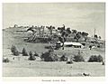
Frogmore copper mine in 1899
_p115_FROGMORE_COPPER_MINE.jpg)
