
Boorowa facts for kids
Quick facts for kids BoorowaNew South Wales |
|
|---|---|

Marsden Street
|
|

Boorowa
Location in New South Wales
|
|
| Established | 1843 |
| Postcode(s) | 2586 |
| Elevation | 490 m (1,608 ft) |
| Location |
|
| LGA(s) | Hilltops Council |
| State electorate(s) | Goulburn |
| Federal Division(s) | Hume |
Boorowa (/buːroʊwə/) is a small farming town in the Hilltops Region of New South Wales, Australia. It is located in a valley about 340 kilometers (210 miles) southwest of Sydney. The town sits around 490 meters (1,600 feet) above sea level. Boorowa is part of the Hilltops Council local government area.
Contents
Discovering Boorowa's Past
Early Days and Aboriginal Heritage
Long ago, the Wiradjuri and Gandangara Aboriginal Australians lived in the Boorowa area. The name 'Burrowa', which was the original spelling, comes from their language. It is thought to mean 'plains turkey', a native bird found in the region.
First Europeans Arrive
The first European to explore this area was a surveyor named George Evans in 1815. Unofficial settlement began in 1821 with two Irishmen, Rodger Corcoran and Ned Ryan. They were former convicts who had earned their 'ticket of leave', which allowed them to live and work freely.
The first official land grant in the area was given to Thomas Icely in 1829. By 1837, a mill, an inn, and several houses were already operating on the land where Boorowa now stands.
Founding the Town
In 1842, Governor Gipps suggested creating a village called 'Burrowa'. It was first planned for a different spot, but that location wasn't suitable. So, the village was officially established on its current site in 1843.
In the early years, the area was quite wild. There were arguments over land, stolen animals, and other troubles because the area was far from law enforcement. Outlaws, sometimes called bushrangers, would hide in the mountains and raid the town and nearby farms.
Farming and Gold
Large farms were set up by people known as squatters. Later, new laws in 1861, called the Robertson Land Acts, made it easier for more settlers to get land. Many 'ticket of leave' men were able to buy small plots of land at a low cost.
The area became known for farming. Gold was also found nearby at Carcoar, Browns Creek, and Kings Plains. This helped the district grow even more. Besides gold, people also mined for copper and iron. A copper mine owned by Samuel Marsden operated until 1900.


Boorowa's Population Growth
In 2011, Boorowa had 1,211 people. This number grew to 1,641 in 2016 and reached 1,888 people by the 2021 census.
The Arrival of the Railway
A Long Wait for Trains
For 40 years, the people of Boorowa and their local politician asked the government for a railway line. They wanted the main southern line to pass through their town. However, the towns of Yass and Murrumburrah were chosen instead.
The next best option was a branch line to Boorowa. This line finally opened on October 10, 1914.
Railway Brings Change
The arrival of the railway helped Boorowa grow a lot. It was around this time that the town's name officially changed from "Burrowa" to "Boorowa". Boorowa then became the main service center for the local farms, taking over from Carcoar.
Boorowa became a municipality (a self-governing town) in 1888. By the early 1900s, a butter factory and freezing works were major employers in the town. Passenger trains stopped running in 1980, and the railway line from Galong to Boorowa closed in 1987. Even after the official name change, the local newspaper kept the old spelling "Burrowa" on its front page until January 1951.
Connecting Boorowa: Infrastructure Milestones
Over 180 years, many important services connected Boorowa to the rest of the world.
- The first Post Office and mail service started in 1835.
- The electric telegraph arrived in 1866, allowing fast messages.
- Voice telephone service began in 1906.
- Electric street lighting came in the 1920s, powered by the town's own generator.
- Later, in 1938, the town and its homes were connected to the Burrinjuck Hydro electricity system, providing power from water.
Boorowa's Natural Environment
Rivers and Rich Soil
Boorowa is located on the Boorowa River, which flows into the Lachlan River. The Murrumbidgee River also drains the southern part of the Boorowa district. The soil in the area is very rich. It's volcanic soil that has been washed down over thousands of years from an old volcano called Mount Canemumbola.
Boorowa's Climate
Boorowa has an oceanic climate, which means it has warm summers and cool winters.
| Climate data for Boorowa Post Office, New South Wales, Australia (1947-1969 temperatures, precipitation 1882-present); 488 m AMSL | |||||||||||||
|---|---|---|---|---|---|---|---|---|---|---|---|---|---|
| Month | Jan | Feb | Mar | Apr | May | Jun | Jul | Aug | Sep | Oct | Nov | Dec | Year |
| Mean daily maximum °C (°F) | 29.5 (85.1) |
28.9 (84.0) |
26.6 (79.9) |
21.1 (70.0) |
15.9 (60.6) |
12.7 (54.9) |
11.9 (53.4) |
13.3 (55.9) |
17.4 (63.3) |
20.1 (68.2) |
23.0 (73.4) |
27.4 (81.3) |
20.7 (69.2) |
| Daily mean °C (°F) | 21.1 (70.0) |
21.0 (69.8) |
18.5 (65.3) |
13.4 (56.1) |
9.4 (48.9) |
7.2 (45.0) |
6.0 (42.8) |
7.2 (45.0) |
10.2 (50.4) |
13.1 (55.6) |
15.2 (59.4) |
19.1 (66.4) |
13.5 (56.2) |
| Mean daily minimum °C (°F) | 12.7 (54.9) |
13.0 (55.4) |
10.3 (50.5) |
5.7 (42.3) |
2.9 (37.2) |
1.6 (34.9) |
0.0 (32.0) |
1.0 (33.8) |
3.0 (37.4) |
6.1 (43.0) |
7.4 (45.3) |
10.8 (51.4) |
6.2 (43.2) |
| Average rainfall mm (inches) | 50.7 (2.00) |
42.8 (1.69) |
47.7 (1.88) |
46.7 (1.84) |
46.7 (1.84) |
55.4 (2.18) |
52.7 (2.07) |
55.1 (2.17) |
50.6 (1.99) |
56.9 (2.24) |
50.5 (1.99) |
53.0 (2.09) |
608.8 (23.98) |
| Average rainy days (≥ 1.0 mm) | 3.9 | 3.4 | 3.7 | 3.9 | 5.0 | 6.4 | 7.0 | 7.3 | 6.0 | 5.8 | 5.0 | 4.2 | 61.6 |
| Source: Australian Bureau of Meteorology (1947-1969 temperatures, precipitation 1882-present) | |||||||||||||
Famous People from Boorowa
Many interesting people have connections to Boorowa:
- Jelisa Apps (born 1990) – a journalist and TV presenter.
- Frederick Ashton (1866−1941) – a circus owner.
- Eric Bryce AM (1932−2007) – a music teacher and composer.
- Dorothy Cumming (1894-1983) – a silent film actress.
- Marguerite Ludovia Dale (1883−1963) – a feminist and playwright.
- Thomas Jenkins (born 2001) – a rugby league player.
- Francis McGrath (1866-1947) – a jockey and horse trainer.
- James Morrison AM (born 1962) – a famous jazz musician.
- John Quinn (1862−1937) – an expert in sheepdogs and a veterinary surgeon.
- Karen Webb APM – the Commissioner of the New South Wales Police Force.
- John Willcock (1879−1956) – an engine driver who became the 15th Premier of Western Australia.
Fun Events in Boorowa
Boorowa hosts some exciting events:
- Agricultural Show: Boorowa's big agricultural show happens every March. It's a chance to see local farming, animals, and more.
- Irish Woolfest: On the October long weekend, Boorowa holds its famous Irish Woolfest. A highlight is the "Running of the Sheep" right down the main street!
Gallery
-
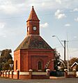
Anzac War Memorial, Marsden Street Boorowa, constructed in 1933
-
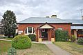
Boorowa Museum
-
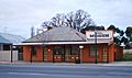
Boorowa Post Office, constructed in 1876
-
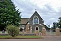
Roman Catholic Church, constructed in 1877


