
Carcoar, New South Wales facts for kids
Quick facts for kids CarcoarNew South Wales |
|||||||||
|---|---|---|---|---|---|---|---|---|---|

Belubula Street
|
|||||||||

Carcoar
Location in New South Wales
|
|||||||||
| Established | 1839 | ||||||||
| Postcode(s) | 2791 | ||||||||
| Elevation | 720 m (2,362 ft) | ||||||||
| Location | |||||||||
| LGA(s) | Blayney Shire | ||||||||
| State electorate(s) | Bathurst | ||||||||
| Federal Division(s) | Calare | ||||||||
|
|||||||||
Carcoar is a small, historic town in the Central West region of New South Wales, Australia. It is part of the Blayney Shire. In 2021, about 271 people lived there.
The town is located just off the Mid-Western Highway. It is about 258 kilometres (160 miles) west of Sydney and 52 kilometres (32 miles) south-west of Bathurst. Carcoar sits 720 metres (2,362 feet) above sea level in a green valley. The town's buildings are found on both sides of the Belubula River.
Carcoar is special because it is the third oldest European settlement west of the Blue Mountains. The name Carcoar comes from the Gundungurra Aboriginal language. It means either 'frog' or 'kookaburra'. Nearby towns include Blayney, Millthorpe, and Mandurama.
This town was once a very important government centre in Western New South Wales. Today, the National Trust has recognised Carcoar for its many well-preserved 19th-century buildings. These buildings help us understand what life was like in Australia long ago. St Paul's Anglican Church is one of the oldest churches in New South Wales. Its graves date back to the 1800s.
Contents
A Look Back: Carcoar's Past
First People and Early Settlers
The original people of this area were the Wiradjuri Aboriginal people. The first European to explore here was a surveyor named George Evans. In 1815, he travelled south-west from Bathurst and saw signs that the Wiradjuri lived there. The word Belubula is also a Wiradjuri word, meaning 'stony river'.
European settlers first arrived in 1821. The first official land grant was given to Thomas Icely in 1829. He named his large property Coombing. By 1836, Carcoar was a small stop with an inn, a blacksmith, and a store.
In 1838, Thomas Icely asked for a village to be created to serve his estate. So, on September 29, 1839, Carcoar officially became a town. It was only the third settlement west of the Blue Mountains to be made official.
Growing as a Town
The first land lots in Carcoar were sold in 1840. By 1850, Carcoar was the second largest town west of the mountains, after Bathurst. It became a key place for banking and government in the area.
The town's public school opened in 1857. It has been a school ever since, making it one of Australia's oldest schools that has always been open. The main street, Naylor Street, is named after the first Anglican minister, Reverend Thomas Beagley Naylor.
A courthouse and lock-up were built in 1842. The courthouse was also used for church services. A new, more decorative courthouse was built between 1879 and 1882.
The Gold Rush and Railways
When gold was discovered further west in the mid-1860s, Carcoar's importance started to fade. The government began building many important public buildings in the late 1870s.
The town's location in a steep valley made it hard to build a railway. In 1874, the railway went to Blayney, which is 13 kilometres (8 miles) north-east of Carcoar. This was a setback for the town. By the early 1880s, Carcoar's population was getting smaller.
Carcoar finally got a railway line in 1888. This was part of the Blayney–Demondrille railway line, which connected to the Main Southern Line. Passenger trains stopped running between Cowra and Blayney (including Carcoar) in the 1980s.
Bushrangers and Law Enforcement
As Carcoar grew in the mid-1800s, it also faced problems with crime. Renegade convicts and bushrangers became more active in the late 1830s. To deal with this, local leaders threatened to use strict rules and remove privileges for convicts in 1841. After bushranger Paddy Curran was caught, and more police arrived, the crime problems mostly settled down.
John Peisley was a well-known horse thief in the early 1850s. He was caught and sent to Cockatoo Island near Sydney. There, he met another prisoner named Frank Gardiner. After being released, Peisley started robbing people on highways. Frank Gardiner and Johnny Gilbert later joined him. Peisley was caught in 1862 and hanged in Bathurst.
On July 13, 1863, the famous bushranger Ben Hall, along with Johnny Gilbert and John O'Meally, tried to rob the Carcoar Commercial Bank during the day. This was Australia's first bank robbery attempt. A bank teller fired a shot, and the gang ran away without taking anything. They did shoot the bank manager as he returned.
Later, Ben Hall's gang, including Johnny Vane and Mickey Bourke, robbed a jeweller's shop and a hotel in Bathurst. They escaped while exchanging shots with police. Weeks later, Mickey Bourke was killed during a hold-up in Rockley. Ben Hall died in a gunfight in 1865. In his three years as a leader, his gang robbed mail coaches, held up people, and stole racehorses.
Mining in Carcoar
Copper was mined near Coombing Park at different times between 1848 and 1878. Iron ore was also mined there from 1899 to 1923. There was also gold in the area, at the Three Mile Diggings west of Carcoar.
Carcoar was also the site of Australia's first recorded uranium discovery in 1894. The uranium was found inside a cobalt mine that operated from 1888 to 1895.
A Possible Capital City
An area called 'Forest Reefs' was once considered as a possible site for Australia's national capital. This area was right next to the town of Carcoar. It is not the same as the modern-day place called Forest Reefs.
Carcoar's Weather and Climate
Carcoar has hotter summers and colder winters compared to Bathurst. Sometimes snow can fall, and sleet is common in winter. Winters are much wetter than in Bathurst.
| Climate data for Carcoar (1907–1969, rainfall 1881–1970); 720 m AMSL; 33.62° S, 149.13° E | |||||||||||||
|---|---|---|---|---|---|---|---|---|---|---|---|---|---|
| Month | Jan | Feb | Mar | Apr | May | Jun | Jul | Aug | Sep | Oct | Nov | Dec | Year |
| Mean daily maximum °C (°F) | 29.8 (85.6) |
29.2 (84.6) |
26.3 (79.3) |
21.0 (69.8) |
15.8 (60.4) |
12.3 (54.1) |
11.5 (52.7) |
13.4 (56.1) |
17.4 (63.3) |
21.3 (70.3) |
24.9 (76.8) |
28.2 (82.8) |
20.9 (69.6) |
| Mean daily minimum °C (°F) | 13.3 (55.9) |
13.2 (55.8) |
10.7 (51.3) |
6.5 (43.7) |
3.3 (37.9) |
1.4 (34.5) |
0.3 (32.5) |
1.1 (34.0) |
3.3 (37.9) |
5.9 (42.6) |
8.5 (47.3) |
11.3 (52.3) |
6.6 (43.8) |
| Average precipitation mm (inches) | 62.5 (2.46) |
50.5 (1.99) |
50.9 (2.00) |
52.1 (2.05) |
59.5 (2.34) |
85.4 (3.36) |
78.1 (3.07) |
78.3 (3.08) |
64.9 (2.56) |
78.5 (3.09) |
63.0 (2.48) |
60.9 (2.40) |
784.6 (30.88) |
| Average precipitation days (≥ 0.2 mm) | 6.2 | 5.4 | 5.6 | 6.0 | 8.2 | 10.8 | 10.9 | 10.6 | 8.8 | 8.5 | 6.8 | 6.3 | 94.1 |
| Source: Australian Bureau of Meteorology; Carcoar | |||||||||||||
Historic Places in Carcoar
Carcoar has several places listed for their historical importance:
- Belubula Street: Old Rectory
- Blayney-Harden railway: Carcoar railway station
- Icely Street: Carcoar School of Arts
- Icely Street: The Saddlery
Carcoar's Population Over Time
In the 2016 Census, there were 200 people living in Carcoar. Most people (88.2%) were born in Australia, and almost everyone (94.4%) spoke only English at home.
| Historical population | ||
|---|---|---|
| Year | Pop. | ±% |
| 1921 | 515 | — |
| 1933 | 478 | −7.2% |
| 1947 | — | |
| 1954 | — | |
| 1961 | — | |
| 1966 | — | |
| 1971 | 378 | — |
| 1976 | 335 | −11.4% |
| 1981 | 277 | −17.3% |
| 1986 | 244 | −11.9% |
| 1991 | 242 | −0.8% |
| 1996 | 223 | −7.9% |
| 2001 | — | |
| 2006 | 218 | — |
| 2011 | 200 | −8.3% |
| 2016 | 200 | +0.0% |
| 2021 | — | |
| Source: Australian Bureau of Statistics data. | ||
Fun Events in Carcoar
Down to Earth Gardening Expo and Plant Fair
This event happens at the Carcoar Show Ground on the last Sunday in April. It focuses on ecology, sustainability, and the joy of gardening. The expo brings together stallholders and visitors from many places.
Carcoar Cup Running Festival
The Carcoar Cup Running Festival takes place on the first weekend in November. It started in 2011 and is now a well-known running event in Australia. It includes a marathon, half marathon, 10K race, 6K Creek Dash, and a kids' race. Runners come from over 170 towns and cities in Australia and from other countries.
Carcoar Show
The annual agricultural show is held on the last weekend of October. It features judged events like flower arranging, stud cattle, and heavy horse pulling competitions.
Australia Day Fair
The yearly Australia Day festival makes Carcoar's population swell to over 3,000 people. The streets are filled with stalls, stagecoach rides, entertainment, food, and historical re-enactments.
Carcoar on Screen
Carcoar has been used as a filming location for many movies and TV shows. These include Jessica (starring Sam Neill), Let the Balloon Go, Brides of Christ, Tommy the Kid, Peter Allen: Not the Boy Next Door (2015), Backtrack (2015) and Ten Pound Poms (2023).
Famous People from Carcoar
- Kurt Fearnley: A world champion in wheelchair athletics. He also crawled the 96-kilometre (60-mile) Kokoda Trail in 2009.
- Edwina Bartholomew: A journalist who owns a hotel in town with her husband, Neil Varcoe.
Images for kids
-
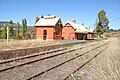
Carcoar Railway Station
-

The Stoke Stable Museum, built by convict labour in 1849
-

Historic machinery outside the Stoke Stable Museum
-
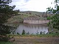
Carcoar Dam with Blayney Wind Farm in background
-
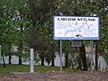
Carcoar Wetland


Panoramic View

A wide view of Carcoar taken from a nearby hill.
