Fruitvale, Colorado facts for kids
Quick facts for kids
Fruitvale, Colorado
|
|
|---|---|

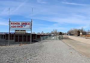
The Grand Valley Canal (right, dry in winter) passes through part of Fruitvale.
|
|

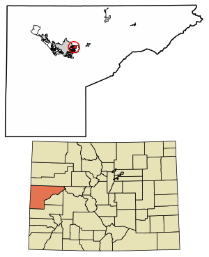
Location in Mesa County, Colorado
|
|
| Country | |
| State | |
| County | Mesa County |
| Area | |
| • Total | 2.895 sq mi (7.50 km2) |
| • Land | 2.895 sq mi (7.50 km2) |
| • Water | 0.0 sq mi (0 km2) |
| Elevation | 4,721 ft (1,439 m) |
| Population
(2020)
|
|
| • Total | 8,271 |
| • Density | 2,857.0/sq mi (1,103.1/km2) |
| Time zone | UTC-7 (MST) |
| • Summer (DST) | UTC-6 (MDT) |
| ZIP code |
81504
|
| Area code(s) | 970 |
| GNIS feature | 2408269 |
Fruitvale is a community located in Mesa County, Colorado, in the United States. It's known as a "census-designated place" (CDP), which means it's an area identified by the U.S. Census Bureau for statistical purposes, but it's not an officially incorporated city or town. Fruitvale is part of the larger Grand Junction area.
In 2020, about 8,271 people lived in Fruitvale. This was an increase from 7,675 people counted in 2010. Even though it's not a city, the Grand Junction post office handles mail for Fruitvale, using the ZIP code 81504.
Contents
Where is Fruitvale Located?
Fruitvale is found in the middle of Mesa County. It shares its western border with the city of Grand Junction. To the east and south, Fruitvale is next to an area called Clifton, which is not officially a town.
The northern edge of Fruitvale is marked by Interstate 70, a major highway. On its southern side, you'll find U.S. Route 6, another important road. The entire area of Fruitvale covers about 2.9 square miles (7.5 square kilometers), and all of this land is dry ground.
Fruitvale's Climate and Weather
Fruitvale experiences a climate with warm summers and cold winters. The hottest month is usually July, with average high temperatures around 92°F (33°C). The coldest month is January, where average low temperatures can drop to about 17°F (-8°C).
The weather changes quite a bit throughout the year. Spring and fall offer milder temperatures, making them pleasant times to visit. This variety in weather is typical for this part of Colorado.
| Climate data for Fruitvale, Colorado | |||||||||||||
|---|---|---|---|---|---|---|---|---|---|---|---|---|---|
| Month | Jan | Feb | Mar | Apr | May | Jun | Jul | Aug | Sep | Oct | Nov | Dec | Year |
| Mean daily maximum °F (°C) | 38 (3) |
46 (8) |
56 (13) |
65 (18) |
75 (24) |
86 (30) |
92 (33) |
90 (32) |
81 (27) |
68 (20) |
51 (11) |
41 (5) |
65.75 (18.75) |
| Mean daily minimum °F (°C) | 17 (−8) |
24 (−4) |
33 (1) |
39 (4) |
48 (9) |
57 (14) |
63 (17) |
61 (16) |
52 (11) |
41 (5) |
29 (−2) |
19 (−7) |
40.25 (4.58) |
| Source: Intellicast | |||||||||||||
Who Lives in Fruitvale?
The number of people living in Fruitvale has grown over the years. This information comes from the United States Census Bureau, which counts everyone in the country every ten years.
| Fruitvale CDP, Colorado | ||
|---|---|---|
| Year | Pop. | ±% |
| 1990 | 5,222 | — |
| 2000 | 6,936 | +32.8% |
| 2010 | 7,675 | +10.7% |
| 2020 | 8,271 | +7.8% |
| Source: United States Census Bureau | ||
The first time Fruitvale was officially recognized as a "census-designated place" for counting purposes was during the 1990 United States Census. Since then, its population has steadily increased, showing that more people are choosing to live in this area.
See also
 In Spanish: Fruitvale (Colorado) para niños


