
Fuencaliente de La Palma facts for kids
Quick facts for kids
Fuencaliente de La Palma
|
|||
|---|---|---|---|
|
|||
 |
|||

Fuencaliente de La Palma
Location in Canary Islands
|
|||
| Country | |||
| Autonomous community | |||
| Province | |||
| Island | |||
| Area | |||
| • Total | 56.42 km2 (21.78 sq mi) | ||
| Elevation | 699 m (2,293 ft) | ||
| Population
(2018)
|
|||
| • Total | 1,709 | ||
| • Density | 30.291/km2 (78.452/sq mi) | ||


Fuencaliente de La Palma, also known as Fuencaliente, is a town located on the southern tip of La Palma island. This island is part of the Canary Islands in Spain. The name "Fuencaliente" means "hot spring" in Spanish. The main village in this area is called Los Canarios. It has been the center of the municipality since 1837. In 2013, about 1,798 people lived here, and the area covers 56.42 square kilometers.
Contents
Exploring Fuencaliente's Geography
The municipality of Fuencaliente covers the very southern part of La Palma island. The land here is mostly shaped by a chain of volcanoes called Cumbre Vieja.
Volcanoes and Fertile Lands
The most southern volcano in this chain is Teneguía. It last erupted in 1971. Even with volcanoes nearby, the soil in Fuencaliente is very rich. Farmers use this land to grow grapes, especially for a famous local wine called malvasia. They also grow many bananas. About 800 hectares of vineyards produce around 2 million liters of wine each year!
Salt Ponds and Location
Near the lighthouse at the island's southernmost point, you can find special pools called salt evaporation ponds. Here, seawater is left to dry in the sun, leaving behind salt. Fuencaliente is located about 23 kilometers southwest of Santa Cruz de la Palma, which is the capital city of the island.
Villages and Communities
Fuencaliente is made up of several smaller villages and communities. Here are some of them, with their populations from 2013:
- Las Caletas (161 people)
- Los Canarios (709 people)
- El Charco (30 people)
- La Fajana (35 people)
- Las Indias (620 people)
- Los Quemados (243 people)
A Glimpse into Fuencaliente's History
Before the Spanish arrived in the 1400s, the area of Fuencaliente was home to the Guanches. They were the native people of the Canary Islands.
The Lost Hot Spring
The name Fuencaliente comes from a natural hot spring called Fuente Santa. This spring was once near the coastline at a place now known as Playa de Echentive. Sadly, in the 1700s, lava flows covered the area and made the spring disappear.
The 1971 Teneguía Eruption
In 1971, the Teneguía volcano erupted. This eruption caused some damage to buildings and properties. However, it also added a small amount of new land to the island. Today, experts are looking into finding underground hot water in the area. They hope to build a special tunnel to bring this warm water to the surface for a unique pool in the future.
Interesting Places to Visit
Fuencaliente has many interesting sites for visitors:
- Cumbre Vieja: This is an active chain of volcanoes and part of a natural park.
- Fuencaliente Lighthouse: A historic lighthouse located at the southern tip of the island.
- Salinas de Fuencaliente or Salinas Teneguía: These are the salt evaporation ponds where salt is collected from the sea.
- The volcano Teneguía: Standing at 438 meters, it's a famous landmark.
Population Over Time
Here's how the population of Fuencaliente has changed over many years:
| Year | Population |
|---|---|
| 1900 | 1,650 |
| 1910 | 1,833 |
| 1920 | 1,841 |
| 1930 | 1,966 |
| 1940 | 2,212 |
| 1950 | 2,270 |
| 1960 | 1,943 |
| 1970 | 1,749 |
| 1980 | 1,664 |
| 1990 | 1,822 |
| 1991 | 1,731 |
| 1996 | 1,735 |
| 2001 | 1,833 |
| 2002 | 1,801 |
| 2003 | 1,857 |
| 2004 | 1,877 |
| 2005 | 1,913 |
| 2013 | 1,798 |
Images for kids
-
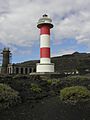
Faro de Fuencaliente
-
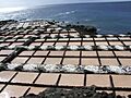
Salinas Teneguía


See also
 In Spanish: Fuencaliente de La Palma para niños
