Galt, Missouri facts for kids
Quick facts for kids
Galt, Missouri
|
|
|---|---|

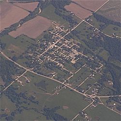
Galt, Missouri seen from the air.
|
|

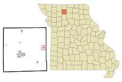
Location of Galt, Missouri
|
|
| Country | United States |
| State | Missouri |
| County | Grundy |
| Area | |
| • Total | 0.29 sq mi (0.74 km2) |
| • Land | 0.29 sq mi (0.74 km2) |
| • Water | 0.00 sq mi (0.00 km2) |
| Elevation | 827 ft (252 m) |
| Population
(2020)
|
|
| • Total | 168 |
| • Density | 587.41/sq mi (227.08/km2) |
| Time zone | UTC-6 (Central (CST)) |
| • Summer (DST) | UTC-5 (CDT) |
| ZIP code |
64641
|
| Area code(s) | 660 |
| FIPS code | 29-26362 |
| GNIS feature ID | 2394846 |
Galt is a small city located in the eastern part of Grundy County, Missouri, in the United States. In 2020, about 168 people lived there.
Contents
A Look Back: Galt's History
Galt started as a town in 1881. This was around the same time a railroad line reached the area. A post office also opened in Galt that same year and has been serving the community ever since.
Exploring Galt's Geography
Galt is located just south of Missouri Route 6. It is about one mile west of the border between Grundy and Sullivan counties. The city of Trenton is about 12 miles to the southwest. The community of Humphreys is 2.5 miles east in Sullivan County.
Two creeks flow near Galt. Medicine Creek passes by to the east along the county line. Little Medicine Creek flows past the east side of the community. The city covers a total area of about 0.29 square miles (0.74 square kilometers), and all of it is land.
Galt's Population Over Time
| Historical population | |||
|---|---|---|---|
| Census | Pop. | %± | |
| 1890 | 653 | — | |
| 1900 | 582 | −10.9% | |
| 1910 | 583 | 0.2% | |
| 1920 | 587 | 0.7% | |
| 1930 | 467 | −20.4% | |
| 1940 | 525 | 12.4% | |
| 1950 | 409 | −22.1% | |
| 1960 | 373 | −8.8% | |
| 1970 | 261 | −30.0% | |
| 1980 | 323 | 23.8% | |
| 1990 | 296 | −8.4% | |
| 2000 | 275 | −7.1% | |
| 2010 | 253 | −8.0% | |
| 2020 | 168 | −33.6% | |
| U.S. Decennial Census | |||
Understanding the 2010 Census
The census is like a big count of all the people living in an area. In 2010, there were 253 people living in Galt. These people lived in 109 different homes, and 70 of those were families.
The city had about 872 people per square mile (336 people per square kilometer). There were 138 housing units, which are places where people can live.
Most of the people in Galt were White (94.9%). A smaller number were African American (1.6%), Native American (0.4%), or Asian (0.4%). Some people (2.4%) were from two or more different races.
Homes and Families
Out of the 109 homes in Galt:
- 30.3% had children under 18 living there.
- 44.0% were married couples living together.
- 13.8% had a female head of the house with no husband present.
- 6.4% had a male head of the house with no wife present.
- 35.8% were not families (like single people living alone).
About 28.4% of all homes had just one person living in them. 11.9% of homes had someone living alone who was 65 years old or older. On average, there were 2.32 people in each home and 2.83 people in each family.
Age and Gender in Galt
The average age of people in Galt was 39.8 years old.
- 24.1% of residents were under 18 years old.
- 9.8% were between 18 and 24 years old.
- 22.8% were between 25 and 44 years old.
- 28% were between 45 and 64 years old.
- 15% were 65 years old or older.
When it came to gender, 51.4% of the people in Galt were male and 48.6% were female.
See also
 In Spanish: Galt (Misuri) para niños
 | Jewel Prestage |
 | Ella Baker |
 | Fannie Lou Hamer |

