Galton's Canal facts for kids
Quick facts for kids Galton's Canal |
|
|---|---|

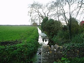
The canal viewed from Westhay Moor Drove
|
|
| Specifications | |
| Locks | 1 |
| History | |
| Original owner | Samuel Galton |
| Principal engineer | Richard Hammett |
| Date of act | 1801 |
| Date of first use | 1822 |
| Date closed | 1850s |
| Geography | |
| Start point | River Brue, Meare |
| End point | North Drain |
| Connects to | River Brue |
Galton's Canal was a short canal in Somerset, England. It was about 2.2 kilometers (1.4 miles) long and had one lock. The canal connected the River Brue to the North Drain. It was used to help improve farmland on Westhay Moor and was open by 1822. The canal stopped being used after the 1850s.
Contents
History of Galton's Canal
Not many details about Galton's Canal have survived. Most of what we know comes from a paper written by Erasmus Galton in 1845. This paper was published in a farming journal. The canal's main goal was to turn a wet, spongy area (a peat bog) into good land for farming.
Why Was the Canal Built?
In 1811, Samuel Galton Jr. owned about 120 hectares (300 acres) of peat bog. This land was in the Meare area of Westhay Moor. An old law from 1790 had divided the moor into smaller plots. But most of it was still wild and only good for cutting peat, which people used as fuel.
Samuel Galton wanted to make his land better for farming. His agent, Richard Hammett, managed the project. Hammett later helped survey the Glastonbury Canal. Local people thought it was impossible to improve this kind of land. They believed any good soil added would just sink into the peat.
However, Galton thought differently. He believed that if the land was properly drained first, the new soil would stay on top. His method involved dividing the land into wide ridges, about 12 meters (40 feet) across. He also dug ditches on both sides of these ridges.
How the Land Was Improved
Peat was moved from the edges of the ridges to their center. Over four to five years, the peat would settle and sink by about 0.9 to 1.2 meters (3 or 4 feet). But it would become firm enough to support cattle. This first step cost about £10.30 per hectare (£4.12 per acre).
The River Brue was a great source of new soil. After heavy rain, the river would leave rich soil on its banks. This soil was perfect for improving the peat land.
Building and Using the Canal
We don't know exactly when the canal was built. Galton's records show costs for the whole project starting in 1811. But the first time soil was moved along the canal was in 1822. About 69 cubic meters (90 cubic yards) of soil were carried then. So, the canal must have been finished by this time.
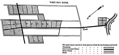
The Brue Drainage Act of 1801 had given permission for the canal to be built. It was about 2.2 kilometers (1.4 miles) long and 4.9 meters (16 feet) wide. The part that connected to the River Brue had raised banks on both sides. After this, there was a small lock. This lock raised the canal's water level so it could cross the moor. The canal then joined the North Drain at its far end. It even continued a little further to help land being reclaimed on the north side of the drain.
Galton noted that after draining the land, native bog plants were replaced by ferns. Once the new soil was added, the ferns died. Then, clover and meadow grass grew naturally without any planting. The soil used was mostly clay or marl. It was added to a depth of about 1.8 meters (6 feet).
Between 1811 and 1842, the project cost about £4770. And a huge amount of soil, about 21,055 cubic meters (27,540 cubic yards), was moved along the canal. This soil was spread onto the land. Boatmen were paid a small amount (3 pence per cubic yard) to dig the soil, boat it, and unload it.
What Happened to the Canal?
In 1830, Galton was told to fix the floodbanks near the canal. The canal was used less and less after the 1850s. It was finally abandoned in 1897. At that time, the local drainage authority built a wall across the canal. This wall had a special flap that still allowed water to flow into the river when the tide was right. Today, the canal is part of the local drainage system.
The Area Today
Galton's map shows three paths (called droves) running next to the canal. To the west is Parson's Drove. To the east are London Drove and Dagg's Lane Drove. The area between London Drove and Dagg's Lane Drove was later used for digging peat. More recently, it has become the Westhay Moor National Nature Reserve.
The Somerset Wildlife Trust manages this nature reserve. It has open water, areas of reeds, and a rare piece of acid mire. This is the largest surviving acid mire in southwest England. The reserve covers about 106 hectares (261 acres). It is home to many kinds of birds, including millions of starlings that visit between November and January.
Points of Interest
| Point | Coordinates (Links to map resources) |
OS Grid Ref | Notes |
|---|---|---|---|
| Start at River Brue | 51°10′47″N 2°47′51″W / 51.1797°N 2.7974°W | ST443425 | |
| Lock | 51°11′04″N 2°47′46″W / 51.1845°N 2.7961°W | ST444430 | |
| End at North Drain | 51°11′55″N 2°47′23″W / 51.1985°N 2.7896°W | ST449446 |
 | Roy Wilkins |
 | John Lewis |
 | Linda Carol Brown |


