Glastonbury Canal facts for kids
Quick facts for kids Glastonbury Canal |
|
|---|---|

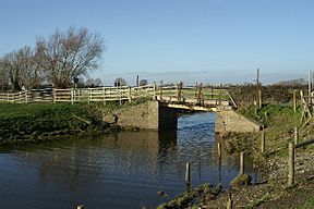
A bridge over the Cripps River, formerly part of the Glastonbury Canal
|
|
| Specifications | |
| Maximum boat length | 64 ft 0 in (19.51 m) |
| Maximum boat beam | 18 ft 0 in (5.49 m) |
| Locks | 2 |
| Status | Part used for drainage |
| History | |
| Original owner | Glastonbury Canal Company |
| Principal engineer | John Rennie |
| Date of act | 1827 |
| Date completed | 1833 |
| Date closed | 1850 |
| Geography | |
| Start point | Glastonbury |
| End point | Highbridge |
The Glastonbury Canal was a waterway that stretched about 14 miles (23 km) from Glastonbury to Highbridge in Somerset, England. It connected to the River Parrett and then to the Bristol Channel, allowing boats to travel to and from the sea. The canal used two special gates called locks to help boats move between different water levels.
This canal was approved by the government in 1827 and opened in 1834. It was run by a company called The Glastonbury Navigation & Canal Company. However, most of the canal stopped being used for boats in 1854. This happened because a railway line was built right next to it, using the path where horses used to pull the boats.
A much older canal had existed in the Middle Ages to help Glastonbury Abbey get stone and supplies. In the early 1800s, people wanted a new canal to boost trade in Glastonbury and help drain the wet Somerset Levels area. Building the canal turned out to be more expensive than planned, and the company faced money problems. There were also engineering challenges, like keeping enough water in the canal and preventing the soft, wet ground from damaging it. Because of these issues, the canal was eventually sold to a railway company. They used the canal to bring materials for building a new railway, which opened in 1854.
Contents
Why the Canal Was Needed
Glastonbury is in a low-lying area called the Somerset Levels. This area has many rivers and drainage ditches, locally known as "rhynes." Long ago, in the Saxon period, there was already a medieval canal that helped the town connect to the river system. Later, the monks at Glastonbury Abbey used these waterways for both draining the land and moving goods.
Changes in Glastonbury
In the 1750s, Glastonbury became a spa town. People believed the water from the Chalice Well spring had healing powers. But this didn't last. The town's main industries, like wool and cloth making, also started to decline. This was because large mills in northern England took over the trade.
Dealing with Floods
The area suffered from severe floods in 1794. To help with this, a law was passed in 1801 called the Brue Drainage Act. This law allowed improvements to the River Brue. They straightened parts of the river near Highbridge and East Huntspill. They also built new channels called the North and South Drains. These drains collected water from the peat moorlands and sent it into the lower River Brue.
As part of these drainage works, two smaller canals, Galton's Canal and Brown's Canal, were built. They were used to help with digging up peat. However, these drainage efforts didn't completely stop the flooding. The people in charge often struggled to collect enough money to pay for the work.
Planning the New Canal
One of the main people who pushed for the new canal was Richard Prat. He was a lawyer in Glastonbury and held important positions in the town. He believed the canal could help Glastonbury's economy and solve its drainage problems. In August 1825, he called a meeting where a clear plan for the canal was made.
Choosing the Best Route
Richard Hammett, a local man, was hired in 1826 to survey the possible routes for the canal. He had experience building a canal through peat land. He looked at two main options:
- The first option followed the River Brue. This was rejected because it would be too expensive to build and would interfere with the river's drainage job.
- The second option followed the South Drain. This drain had been built after the 1794 floods. This route would connect with the River Brue near Cripps Bridge and use an old part of the river at Highbridge for a boat basin.
Hammett thought that the main work for the canal would be adding a path for horses to pull boats. He believed that making the South Drain wider and deeper would also help with drainage. This would save local landowners money, as the canal company would then be responsible for its upkeep. He estimated the cost at £9,000. He didn't think digging through peat would be a big problem, but he seriously underestimated the true cost.
Getting Approval and Funding
A detailed plan was created, showing the likely costs and profits. The canal supporters then worked to get an Act of Parliament (a special law) passed. During this time, another surveyor, John Beauchamp, reviewed the plans. He thought the canal would cost more, around £15,234, which was later increased to £18,000.
The Act of Parliament, which allowed the canal to be built following Hammett's plans, was approved on May 28, 1827. The company was allowed to raise £18,000 by selling shares. They could also borrow an extra £5,000 if needed.
Building the Canal
Building work started after the land was bought. But it quickly became clear that the first surveys weren't accurate. A famous canal engineer named John Rennie was asked for advice. He suggested three options for boat sizes. The company chose an option that allowed larger "coasters" (ships that sailed along the coast) to use the canal. This meant the locks needed to be 64 feet (20 m) long and 18 feet (5.5 m) wide. This option was estimated to cost £28,720. Work began again in July 1828.
Engineering Challenges
At the Glastonbury end, the canal had to cross the South Drain and the River Brue. Rennie suggested using inverted syphons (pipes that go under a river) instead of locks. A large cast iron aqueduct (a bridge for water) for the River Brue crossing was bought for almost £3,000. At the Highbridge end, plans for a large harbor were dropped. The entrance lock was moved further along the old River Brue. This saved money but meant ships didn't have to pay to reach Highbridge.
Money Troubles
The company struggled to raise all the money they had promised. There were financial difficulties. In 1830, the drainage officials were unhappy with some of the work at Highbridge. They reported that the contractor had "run away," and work stopped in 1831. The company also failed to pay a £1,000 deposit required to cover any costs the drainage officials might have. Even Rennie, the engineer, threatened to sue because he hadn't been paid his full fee. The total cost of building the canal was about £30,000, but some debts were never paid. In December 1831, the company borrowed £5,000 from the government.
The Canal Opens

The Glastonbury Canal finally opened on August 15, 1833. There were big celebrations at both ends of the canal. Nine days later, another celebration was held for local traders. The first cargo of wood from Canada arrived in July 1835.
The canal seemed successful at first, but it didn't make enough money. There were also problems with water levels in the upper part of the canal. In 1840, the Prat brothers, whose law firm had been very involved in creating the canal, disappeared. They left a large financial hole. It seems they had paid for many of the extra building costs and might have used money from their clients. They were declared bankrupt, and Richard Prat lost his jobs. Their firm's collapse badly affected Glastonbury's economy.
Ongoing Problems
In the upper section, the canal's design prevented the surrounding land from draining properly. Since the land was made of peat, it started to swell. This caused the canal itself to rise, and the clay lining (which kept water in) cracked. This led to more water loss and a shallower canal, making it harder for boats to pass. Goods had to be moved to smaller boats at Highbridge, which added to the delivery costs. By 1848, the canal was only carrying about 4,000 long tons (4,100 t) of goods per year.
The Canal Closes
Railways arrived in the area in 1841. The Bristol and Exeter Railway opened part of its line, reaching Exeter by 1844. In late 1846, the railway company tried to buy the canal. They wanted to stop other railway companies from using it. The sale was agreed in 1847 and approved by Parliament in 1848. The canal company was officially closed in 1851.
There were disagreements between the new railway owners and the drainage officials. The railway company planned a railway line between Highbridge and Glastonbury in 1850. The Somerset Central Railway was approved by Parliament in 1852. The canal was given to this new railway company. It was used to quickly transport materials for building the railway. The railway line followed the canal's route very closely, with much of it built on the old towpath.
The Glastonbury Canal officially closed on July 1, 1854. The locks and water bridges in the upper section were taken apart. The railway opened on August 17, 1854.
What Happened Next
The lower parts of the canal were given to the drainage officials to use as a ditch. A final section was kept by the railway company as a wharf (a place for loading and unloading boats) until 1936. After that, it was also given to the drainage officials and filled in. The Central Somerset Railway later joined with another company to become the Somerset and Dorset Railway. The main railway line to Glastonbury closed in 1966. However, branches to a dairy at Bason Bridge and the Highbridge Wharf lasted until 1972.
The Canal's Route

The Glastonbury Canal began at a lock on an old part of the River Brue. This part of the river had been cut off by a new channel in 1801 and filled in. The canal then followed the Brue to Cripps Bridge. After that, it followed the Cripps River to Gold Corner. This first part of the Cripps River was originally a loop of the River Brue that was bypassed in 1801. Gold Corner is where the Huntspill River, the Cripps River, and the South Drain all meet.
The canal then followed the widened South Drain. A lock at Shapwick raised the canal's water level. The South Drain then ran parallel to the canal but to its north. The railway line ran between the two waterways. It crossed to the south side of the canal just after a single-arched aqueduct and syphon over the South Drain.
The remains of a three-arched aqueduct and syphon over the River Brue can still be seen near the old railway bridge. From there, the canal headed towards Glastonbury. It passed by the Ham Wall and Street Heath nature reserves. The canal made a sharp right turn just before its end point, which was a basin located near the old Glastonbury and Street railway station.
| Point | Coordinates (links to map & photo sources) |
Notes |
|---|---|---|
| Canal wharf in Glastonbury | 51°08′56″N 2°43′40″W / 51.1489°N 2.7279°W | Approximate location |
| Aqueduct over River Brue | 51°08′58″N 2°44′42″W / 51.1494°N 2.7449°W | |
| Ashcott Station | 51°09′12″N 2°47′18″W / 51.1534°N 2.7883°W | Station located next to canal at Ashcott Corner |
| Shapwick Station | 51°10′02″N 2°49′39″W / 51.1673°N 2.8274°W | Station located next to canal |
| Edington Junction Station | 51°10′54″N 2°52′19″W / 51.1817°N 2.872°W | Station located next to canal |
| Gold Corner | 51°11′02″N 2°54′23″W / 51.1838°N 2.9063°W | Meeting point of canal with Cripps River and Huntspill River |
| Cripps River bridge | 51°11′41″N 2°54′18″W / 51.1948°N 2.9051°W | Crossing for Long Moor Drove |
| Cripps River meets River Brue | 51°12′08″N 2°54′57″W / 51.2023°N 2.9158°W | |
| Bason Bridge | 51°12′27″N 2°56′15″W / 51.2076°N 2.9376°W | |
| Starting point in Highbridge | 51°13′12″N 2°59′06″W / 51.22°N 2.9849°W |
 | Aurelia Browder |
 | Nannie Helen Burroughs |
 | Michelle Alexander |


