
Galtür facts for kids
Quick facts for kids
Galtür
|
||
|---|---|---|
 |
||
|
||

Galtür
Location in Austria
|
||
| Country | Austria | |
| State | Tyrol | |
| District | Landeck | |
| Area | ||
| • Total | 121.23 km2 (46.81 sq mi) | |
| Elevation | 1,584 m (5,197 ft) | |
| Time zone | UTC+1 (CET) | |
| • Summer (DST) | UTC+2 (CEST) | |
| Postal code |
6563
|
|
| Area code | 05443 | |
| Vehicle registration | LA | |
| Website | www.galtuer.gv.at | |

Galtür is a small village and a popular ski resort in Austria. It is located in the upper Paznaun valley, in the state of Tyrol. You can find it in the Central Eastern Alps, about 35 kilometers southwest of Landeck. It is also close to the borders of Vorarlberg and Switzerland.
Contents
History of Galtür: From Settlement to Tourism
Galtür was first settled by different groups of people. Some came from the south, called the Engadiners. Others came from the west, known as the Walsers and Vorarlbergers. People from Tyrol also settled here from the east. The name Galtür actually comes from the Engadiner word Cultura, which means "cultivation."
Early Challenges and Growth
During the Thirty Years' War, Galtür faced a lot of damage. The church and many homes were burned down. For a long time, Galtür was a very poor village. In the 1800s, the first roads were built through the Paznaun valley. At that time, Galtür only had a church, an inn, and eight houses.
Things started to change when the first hotel was built. Soon after, the Jamtalhütte was also constructed. As more tourists began to visit, Galtür and the entire valley became much more successful.
The 1999 Galtür Avalanche: A Natural Disaster
On February 23, 1999, a very large avalanche hit Galtür. An avalanche is a huge slide of snow down a mountain. This one was 164 feet (50 meters) high and moved at 290 kilometers per hour (180 mph). It happened incredibly fast, in less than 60 seconds.
The powerful snow wall overturned cars and destroyed buildings. It buried 57 people. Sadly, 31 people died before rescue teams could reach them. This avalanche was the worst in the Alps in 40 years.
Rescue Efforts and Causes
Because of the danger of more avalanches, thousands of tourists were flown out of the Paznaun valley by helicopters. Military and civilian helicopters from Austria, Germany, Switzerland, France, and the United States helped. It was one of the biggest rescue operations in Austria's recent history.
The avalanche was caused by three big weather systems from the Atlantic Ocean. These systems brought a lot of snow, about 4 meters (13 feet) in total. The snow then froze and thawed, creating a weak layer. More snow fell on top of this. Strong winds also created huge piles of snow. Eventually, about 170,000 tons of snow slid down onto the village.
Galtür Ski Resort: Silvapark for All Skiers
Galtür is a very popular place for tourists in winter. It has a ski resort called Silvapark. This resort offers 40 kilometers (25 miles) of well-prepared ski slopes. There are many different types of slopes to explore.
Family-Friendly Skiing
Galtür is known as a great ski area for families. Most of the ski slopes are easy to medium difficulty. This makes them perfect for beginners and families. Even so, experienced skiers can find challenging runs. There are also many deep snow slopes that are untouched.
The resort has 10 mountain railways and lifts. One of these is the eight-seater Alpkogel gondola. On Wednesday evenings, you can even go night skiing on a special floodlit slope.
Exploring Silvapark
The Silvapark ski resort is located about 2 kilometers (1.2 miles) outside the main village in a smaller area called Wirl. Ski buses run regularly along the main road through Galtür. These buses connect the ski area to other places in the valley, like Ischgl, Kappl, and See.
In Galtür, the bus stops are at Hotel Alpenrose, Dorfplatz, and Alpinarium. In Wirl, there is a stop right next to the Birkhahnbahn chair lift. From Wirl, skiers and snowboarders can take either the Birkahahnbahn chair lift or the Alpkogelbahn Gondola up the mountain.
Slopes and Facilities
Silvapark has 40 kilometers of groomed slopes. These are served by 3 chair lifts, 1 gondola, and 5 smaller tow lifts. Many runs are marked Blue and Red, which means they are good for families and beginners.
The resort also has more difficult Red and Black runs. These, along with off-piste areas, are great for advanced skiers and snowboarders. You can find off-piste opportunities through trees and between runs, especially near the Breitspitzbahn chair lift. This area is often quieter and has better snow conditions.
There are several mountain huts and restaurants on the mountain. They offer traditional Austrian food and a friendly atmosphere. Most have both indoor and outdoor dining areas. Some hotels at the bottom of the Alpkogelbahn Gondola offer "ski-in, ski-out" access. This means you can ski right to and from your hotel, so you don't need to take a ski bus.
Climate
| Climate data for Galtür: 1587m (1991−2020 normals) | |||||||||||||
|---|---|---|---|---|---|---|---|---|---|---|---|---|---|
| Month | Jan | Feb | Mar | Apr | May | Jun | Jul | Aug | Sep | Oct | Nov | Dec | Year |
| Record high °C (°F) | 9.9 (49.8) |
12.5 (54.5) |
15.3 (59.5) |
19.3 (66.7) |
24.5 (76.1) |
30.3 (86.5) |
29.6 (85.3) |
28.1 (82.6) |
24.6 (76.3) |
23.1 (73.6) |
16.4 (61.5) |
11.5 (52.7) |
30.3 (86.5) |
| Mean daily maximum °C (°F) | −0.5 (31.1) |
0.7 (33.3) |
4.1 (39.4) |
8.3 (46.9) |
12.9 (55.2) |
17.1 (62.8) |
18.4 (65.1) |
18.0 (64.4) |
14.6 (58.3) |
10.3 (50.5) |
3.9 (39.0) |
0.1 (32.2) |
9.0 (48.2) |
| Daily mean °C (°F) | −4.7 (23.5) |
−4.1 (24.6) |
−0.5 (31.1) |
3.3 (37.9) |
7.9 (46.2) |
11.4 (52.5) |
13.3 (55.9) |
13.1 (55.6) |
9.3 (48.7) |
5.6 (42.1) |
−0.1 (31.8) |
−3.9 (25.0) |
4.2 (39.6) |
| Mean daily minimum °C (°F) | −8.6 (16.5) |
−9.4 (15.1) |
−5.4 (22.3) |
−1.7 (28.9) |
2.4 (36.3) |
5.7 (42.3) |
7.3 (45.1) |
7.3 (45.1) |
4.0 (39.2) |
0.5 (32.9) |
−4.1 (24.6) |
−7.5 (18.5) |
−0.8 (30.6) |
| Record low °C (°F) | −23.6 (−10.5) |
−26.5 (−15.7) |
−25.6 (−14.1) |
−17.9 (−0.2) |
−9.5 (14.9) |
−3.7 (25.3) |
−0.6 (30.9) |
−1.1 (30.0) |
−6.7 (19.9) |
−15.1 (4.8) |
−20.9 (−5.6) |
−24.2 (−11.6) |
−26.5 (−15.7) |
| Average precipitation mm (inches) | 50.0 (1.97) |
39.9 (1.57) |
49.8 (1.96) |
39.9 (1.57) |
75.2 (2.96) |
113.6 (4.47) |
128.4 (5.06) |
141.7 (5.58) |
84.5 (3.33) |
62.4 (2.46) |
53.0 (2.09) |
52.3 (2.06) |
890.7 (35.08) |
| Average snowfall cm (inches) | 87.9 (34.6) |
92.7 (36.5) |
80.2 (31.6) |
57.1 (22.5) |
13.0 (5.1) |
3.2 (1.3) |
0.3 (0.1) |
0.7 (0.3) |
7.2 (2.8) |
28.3 (11.1) |
69.4 (27.3) |
91.3 (35.9) |
531.3 (209.1) |
| Average precipitation days (≥ 1.0 mm) | 8.1 | 7.0 | 9.1 | 9.3 | 12.5 | 14.3 | 14.6 | 14.8 | 11.1 | 8.9 | 9.0 | 9.1 | 127.8 |
| Average snowy days (≥ 1 cm) | 30.9 | 28.3 | 30.3 | 20.8 | 3.4 | 0.4 | 0.0 | 0.1 | 1.4 | 5.8 | 17.8 | 28.4 | 167.6 |
| Source: Central Institute for Meteorology and Geodynamics | |||||||||||||
| Climate data for Galtür (1971–2000) | |||||||||||||
|---|---|---|---|---|---|---|---|---|---|---|---|---|---|
| Month | Jan | Feb | Mar | Apr | May | Jun | Jul | Aug | Sep | Oct | Nov | Dec | Year |
| Record high °C (°F) | 10.0 (50.0) |
11.4 (52.5) |
17.0 (62.6) |
17.8 (64.0) |
23.4 (74.1) |
25.6 (78.1) |
29.6 (85.3) |
29.4 (84.9) |
26.6 (79.9) |
21.2 (70.2) |
16.4 (61.5) |
12.1 (53.8) |
29.6 (85.3) |
| Mean daily maximum °C (°F) | −0.3 (31.5) |
0.6 (33.1) |
3.6 (38.5) |
6.3 (43.3) |
12.3 (54.1) |
15.2 (59.4) |
17.8 (64.0) |
17.6 (63.7) |
14.6 (58.3) |
10.5 (50.9) |
3.3 (37.9) |
0.3 (32.5) |
8.5 (47.3) |
| Daily mean °C (°F) | −5.5 (22.1) |
−5.3 (22.5) |
−2.1 (28.2) |
1.0 (33.8) |
6.4 (43.5) |
9.3 (48.7) |
11.7 (53.1) |
11.4 (52.5) |
7.9 (46.2) |
3.9 (39.0) |
−1.9 (28.6) |
−4.5 (23.9) |
2.7 (36.9) |
| Mean daily minimum °C (°F) | −9.5 (14.9) |
−9.6 (14.7) |
−6.2 (20.8) |
−3.1 (26.4) |
1.4 (34.5) |
4.1 (39.4) |
6.3 (43.3) |
6.4 (43.5) |
3.3 (37.9) |
−0.3 (31.5) |
−5.7 (21.7) |
−8.3 (17.1) |
−1.8 (28.8) |
| Record low °C (°F) | −29.4 (−20.9) |
−25.0 (−13.0) |
−27.5 (−17.5) |
−16.4 (2.5) |
−13.3 (8.1) |
−5.0 (23.0) |
−2.6 (27.3) |
−3.6 (25.5) |
−6.8 (19.8) |
−16.0 (3.2) |
−22.5 (−8.5) |
−26.5 (−15.7) |
−29.4 (−20.9) |
| Average precipitation mm (inches) | 78.9 (3.11) |
62.9 (2.48) |
74.4 (2.93) |
65.4 (2.57) |
87.6 (3.45) |
134.9 (5.31) |
156.2 (6.15) |
142.7 (5.62) |
100.0 (3.94) |
67.1 (2.64) |
80.2 (3.16) |
77.2 (3.04) |
1,127.5 (44.39) |
| Average snowfall cm (inches) | 89.5 (35.2) |
103.4 (40.7) |
96.8 (38.1) |
74.5 (29.3) |
15.2 (6.0) |
4.5 (1.8) |
0.6 (0.2) |
1.1 (0.4) |
6.0 (2.4) |
18.1 (7.1) |
68.8 (27.1) |
90.8 (35.7) |
569.3 (224.1) |
| Average precipitation days (≥ 1.0 mm) | 10.3 | 8.5 | 11.2 | 11.8 | 12.6 | 14.8 | 15.3 | 14.1 | 10.8 | 9.1 | 10.2 | 10.7 | 139.4 |
| Average relative humidity (%) (at 14:00) | 63.1 | 60.0 | 56.4 | 56.3 | 52.2 | 55.3 | 53.9 | 55.4 | 53.4 | 54.1 | 64.1 | 66.3 | 57.5 |
| Source: Central Institute for Meteorology and Geodynamics | |||||||||||||
Gallery
-
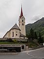
Wallfahrtskirche Mariä Geburtstag Catholic parish church
-
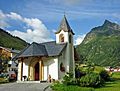
Chapel at Wirl, Galtür
-
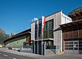
Alpinarium
-
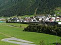
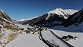
View of Galtür from the avalanche path
-
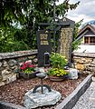
Memorial for the 31 avalanche victims who died in Galtür in February 1999
-
Galtür and the Silvretta Strasse road
-
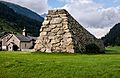
Avalanche protection in Tschaffein


See also
 In Spanish: Galtür para niños
