
Garden Club of America Entrance Markers in Washington, D.C. facts for kids
Quick facts for kids |
|
|
Garden Club of America Entrance Markers in Washington, D.C. MPS
|
|

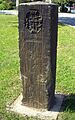
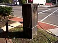
Cartouche of the District of Columbia
|
|
| Architect | Edward W. Donn, Jr. |
|---|---|
| Architectural style | Late 19th and early 20th Century Movements |
| NRHP reference No. | 64501007 |
The Garden Club of America Entrance Markers in Washington, D.C. are special stone markers. They stand at important entry points into Washington, D.C. from Maryland. There are seven of these markers in total. They are like welcome signs, showing you are entering the capital city! These markers are listed on the National Register of Historic Places, which means they are important historical sites.
Contents
History of the Markers
Why Were These Markers Built?
The Garden Club of America put up these markers in 1932 and 1933. They did this to celebrate the 200th birthday of George Washington. Other big events for this celebration included opening the Arlington Memorial Bridge and the George Washington Memorial Parkway.
The Garden Club also placed similar markers at other entrances to the city. This included spots where you enter from Virginia, like near the Key Bridge.
What Did the Markers Look Like?
Originally, each marker had fences around it. These fences were made of chains held up by four small posts called bollards. There were also special plants around them, designed by Garden Club groups from Maryland and Virginia.
The Club wanted these markers to show people they were crossing a boundary. But not all markers were placed exactly on the city's real border.
What Happened to the Markers Over Time?
Over the years, the seven markers that still exist have faced a lot of wear and tear. Things like weather, pollution, and even cars hitting them have caused damage. Some markers have been moved from their original spots and put back nearby. We don't know what happened to some of the markers that are no longer in place.
For example, a pair of markers was put at the city's north entrance near 16th Street NW and Silver Spring, Maryland. But these are not there anymore. A different kind of entrance marker now stands at that spot.
Who Designed the Markers?
A talented architect named Edward Donn designed these markers for the Garden Club. He got his idea from the famous Mason–Dixon line markers. Those older markers were placed in 1761 to mark the border between Pennsylvania and Maryland.
The Garden Club markers are made from a type of stone called Aquia Creek sandstone. On one side, you can see the Seal of Maryland. On the other side is the Cartouche of the District of Columbia. This cartouche is a special design that shows George Washington with Lady Justice, a laurel wreath (a symbol of victory), the rising sun, and the dome of the U.S. Capitol building.
Where Can You Find the Markers?
The seven markers are located at different points where roads enter Washington, D.C. from Maryland.
- Westmoreland Circle: You'll find two markers here. They are at the meeting point of Western Avenue and Massachusetts Avenue, NW. One marker is under an oak tree and still has its original chain fence. The other is out in the open.
- Friendship Heights: Two markers are located here, near the Friendship Heights Metro Station. They are on the east and west sides of Wisconsin Avenue, just north of Western Avenue.
- Chevy Chase Circle: There are two markers at this circle, where Western Avenue meets Connecticut Avenue. They are inside a grassy area within the circle, close to a fountain.
- Georgia Avenue: One marker is located on a small triangular island. This island is where Georgia Avenue, Alaska Avenue, and Kalmia Road NW all meet. This marker is surrounded by a chain-link fence and shrubs. It used to be in the middle of Georgia Avenue.
List of the Markers
Here is a list of the seven Garden Club of America Entrance Markers, starting from Westmoreland Circle and moving clockwise around the city. The table also shows when each marker was added to the National Register of Historic Places.
| Name | Location | Neighborhood | Date Listed |
|---|---|---|---|
| Garden Club of America Entrance Marker at Westmoreland Circle | Western Avenue and Massachusetts Avenue, NW West side of Circle |
Westmoreland Circle | April 29, 2008 |
| Garden Club of America Entrance Marker at Westmoreland Circle | Western Avenue and Massachusetts Avenue, NW North side of Circle |
Westmoreland Circle | April 29, 2008 |
| Garden Club of America Entrance Marker at Wisconsin Avenue | Wisconsin Avenue at Western Avenue West corner of intersection |
Friendship Heights | May 12, 2008 |
| Garden Club of America Entrance Marker at Wisconsin Avenue | Wisconsin Avenue at Western Avenue North corner of intersection |
Friendship Heights | May 12, 2008 |
| Garden Club of America Entrance Marker at Chevy Chase Circle | Western Avenue and Connecticut Avenue West of center of Circle |
Chevy Chase Circle | April 29, 2008 |
| Garden Club of America Entrance Marker at Chevy Chase Circle | Western Avenue and Connecticut Avenue East of center of Circle |
Chevy Chase Circle | April 29, 2008 |
| Garden Club of America Entrance Marker at Georgia Avenue | Traffic island between Georgia Avenue, Kalmia Road and Alaska Avenue Southeast corner of island |
Shepherd Park | April 29, 2008 |
Images for kids
-
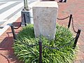
A marker at Westmoreland Circle (2008)
-
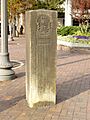
A marker at Wisconsin Avenue (2012)
-
A marker at Friendship Heights (2005)
-
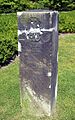
A marker at Chevy Chase Circle (2008)
-
The marker at Georgia Avenue (2011)


