Garden Grove, Florida facts for kids
Quick facts for kids
Garden Grove, Florida
|
|
|---|---|

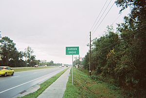
US 41 northbound as it enters Garden Grove
|
|
| Country | United States |
| State | Florida |
| County | Hernando |
| Area | |
| • Total | 0.98 sq mi (2.53 km2) |
| • Land | 0.97 sq mi (2.51 km2) |
| • Water | 0.01 sq mi (0.02 km2) |
| Elevation | 95 ft (29 m) |
| Population
(2020)
|
|
| • Total | 776 |
| • Density | 800.83/sq mi (309.29/km2) |
| Time zone | UTC-5 (Eastern (EST)) |
| • Summer (DST) | UTC-4 (EDT) |
| FIPS code | 12-25475 |
| GNIS feature ID | 0282923 |
Garden Grove is a small community in Florida, also known as Garden Grove Estates. It is located in the middle of Hernando County. This area is called an "unincorporated community" and a "census-designated place" (CDP). This means it's a specific area recognized by the government for counting people, but it doesn't have its own city government. The ZIP Code for Garden Grove is 34604. In 2020, about 776 people lived here.
Contents
Where is Garden Grove Located?
Garden Grove is in the southern part of Hernando County. It shares borders with other communities:
- Masaryktown is to its south.
- South Brooksville is to its north.
- Spring Hill is to its west.
The community is right next to the Hernando County Airport. The main road that goes through Garden Grove is U.S. Route 41.
Even though some places in Garden Grove might use a Brooksville address, the main office for the Southwest Florida Water Management District is located here. This district helps manage water resources in the area. It is across from The Trails of Rivard Golf and Country Club.
How Many People Live Here?
The number of people living in Garden Grove has changed over time.
| Historical population | |||
|---|---|---|---|
| Census | Pop. | %± | |
| 2020 | 776 | — | |
| U.S. Decennial Census | |||
In 2010, the population was 674 people. By 2020, it had grown to 776 people.
Getting Around Garden Grove
The most important road in Garden Grove is U.S. 41. This road runs from the southwest to the northeast. It connects Garden Grove to Masaryktown and goes all the way to Brooksville, which is the main city in Hernando County.
Next to U.S. 41, there's a CSX train track called the Brooksville Subdivision. This track even has a special branch that goes to the airport. This branch was improved when U.S. 41 was made wider.
There are also two other important roads that run from west to east:
- County Road 574 (also called Spring Hill Drive) runs along the northern edge of the Hernando County Airport and ends at U.S. 41.
- County Road 572 (also called Powell Road) runs along the northern part of Garden Grove. It stretches from near Weeki Wachee to Spring Lake.
See also
 In Spanish: Garden Grove (Florida) para niños
 | Shirley Ann Jackson |
 | Garett Morgan |
 | J. Ernest Wilkins Jr. |
 | Elijah McCoy |


