Hernando County, Florida facts for kids
Quick facts for kids
Hernando County
|
||
|---|---|---|

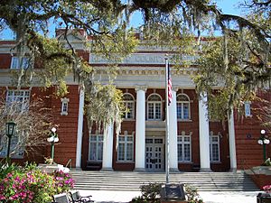
Hernando County Courthouse
|
||
|
||

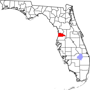
Location within the U.S. state of Florida
|
||
 Florida's location within the U.S. |
||
| Country | ||
| State | ||
| Founded | February 24, 1843 | |
| Named for | Hernando de Soto | |
| Seat | Brooksville | |
| Largest community | Spring Hill | |
| Area | ||
| • Total | 589 sq mi (1,530 km2) | |
| • Land | 473 sq mi (1,230 km2) | |
| • Water | 116 sq mi (300 km2) 19.8%% | |
| Population
(2020)
|
||
| • Total | 194,515 | |
| • Density | 411/sq mi (159/km2) | |
| Time zone | UTC−5 (Eastern) | |
| • Summer (DST) | UTC−4 (EDT) | |
| Congressional district | 12th | |
Hernando County (Spanish: Condado de Hernando) is a county located on the west central coast of Florida, a state in the United States. In 2020, about 194,515 people lived here. The main city where the county government is located is Brooksville. The biggest community in the county is Spring Hill.
Hernando County is part of the larger Tampa Bay Metropolitan Area, which includes cities like Tampa, St. Petersburg, and Clearwater. Around 2005, Hernando County was one of the fastest-growing counties in the entire country!
Contents
History of Hernando County

Around 1840, a place called Fort DeSoto was built in what is now Hernando County. It was located near where Brooksville is today. This fort helped protect the settlers in the area from Native Americans. Fort DeSoto became a small community where people could trade goods and rest while traveling to Tampa. When people started settling near the fort around 1845, it was also known as Pierceville.
Hernando County was officially created on February 27, 1843. This was two years before Florida became a state. Back then, the county was much larger than it is today. It was formed from parts of Alachua, Hillsborough, and Orange Counties. It also included all of what are now Citrus and Pasco Counties.
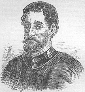
The county was named after Spanish explorer Hernando de Soto. His name is also used for DeSoto County. For a short time in 1844, Hernando County was renamed Benton County. This was to honor Missouri Senator Thomas Hart Benton, who supported the county's creation. However, Benton later changed his mind on some important issues, which made people unhappy. So, in 1850, the county's name went back to Hernando.
In December 1854, the small port town of Bayport was chosen as the county seat. But people living in the eastern part of the county wanted a more central location for the government. By 1855, voters chose a spot inland at the town of Melendez. In 1856, the people of Hernando County decided to rename their new county seat Brooksville. This was to honor Preston Brooks, a politician from South Carolina who was very popular in the South at the time.
In 1855, Joseph Hale, who founded the town, gave land for a county courthouse in the middle of what is now Brooksville. The courthouse was built soon after.
During the Civil War, Hernando County mainly provided food, cotton, and wood to the Southern states (the Confederacy). Even though Union ships tried to block the port of Bayport, people were still able to get supplies through. Because of this, in June 1864, the Union sent about 150–250 soldiers to destroy Confederate supplies in the county. In early July, these soldiers marched from the Anclote River to Brooksville. They faced some resistance from Confederate troops who quickly gathered to protect the city. The Union troops won this fight, which is known as the Brooksville Raid. They then marched to Bayport, where they destroyed Rebel operations. This skirmish between Union raiders and local Confederates is re-enacted every year in the county.
The county courthouse was destroyed by a fire on September 29, 1877. On June 2, 1887, the Florida State Legislature divided Hernando County into three separate counties. These were Pasco County to the south, Citrus County to the north, and Hernando County in the middle. Since then, Hernando County's borders have stayed the same.
Geography of Hernando County
According to the U.S. Census Bureau, Hernando County covers a total area of 589 square miles (1,525 km²). About 473 square miles (1,225 km²) of this is land, and 116 square miles (300 km²) is water. This means about 19.8% of the county is water. The World Atlas USA says that Hernando County is the geographic center of Florida. The land in the county ranges from sea level along the Gulf coast to its highest point of 269 feet (82 meters) at Chinsegut Hill.
Neighboring Counties
- Citrus County, Florida - to the north
- Sumter County, Florida - to the east
- Pasco County, Florida - to the south
Protected Natural Areas
- Chassahowitzka National Wildlife Refuge (a national protected area)
- Weeki Wachee Springs (a state protected area)
- Withlacoochee State Forest (a state protected area)
Other Interesting Places
- Bayport Park
- Brooksville Railroad Depot Museum
- Delta Woods Park
- Veterans Memorial Park
- Tom Varn Park
- Annutteliga Hammock
People of Hernando County
| Historical population | |||
|---|---|---|---|
| Census | Pop. | %± | |
| 1850 | 926 | — | |
| 1860 | 1,200 | 29.6% | |
| 1870 | 2,938 | 144.8% | |
| 1880 | 4,248 | 44.6% | |
| 1890 | 2,476 | −41.7% | |
| 1900 | 3,638 | 46.9% | |
| 1910 | 4,997 | 37.4% | |
| 1920 | 4,548 | −9.0% | |
| 1930 | 4,948 | 8.8% | |
| 1940 | 5,641 | 14.0% | |
| 1950 | 6,693 | 18.6% | |
| 1960 | 11,205 | 67.4% | |
| 1970 | 17,004 | 51.8% | |
| 1980 | 44,469 | 161.5% | |
| 1990 | 101,115 | 127.4% | |
| 2000 | 130,802 | 29.4% | |
| 2010 | 172,778 | 32.1% | |
| 2020 | 194,515 | 12.6% | |
| 2023 (est.) | 212,807 | 23.2% | |
| U.S. Decennial Census 1790-1960 1900-1990 1990-2000 2010-2015 2019 |
|||
The table below shows the different groups of people living in Hernando County in 2010 and 2020.
| Race | Pop 2010 | Pop 2020 | % 2010 | % 2020 |
|---|---|---|---|---|
| White (NH) | 141,847 | 144,060 | 82.1% | 74.06% |
| Black or African American (NH) | 8,165 | 9,507 | 4.73% | 4.89% |
| Native American or Alaska Native (NH) | 483 | 553 | 0.28% | 0.28% |
| Asian (NH) | 1,815 | 2,566 | 1.05% | 1.32% |
| Pacific Islander (NH) | 62 | 86 | 0.04% | 0.04% |
| Some Other Race (NH) | 244 | 868 | 0.14% | 0.45% |
| Mixed/Multi-Racial (NH) | 2,366 | 7,830 | 1.37% | 4.03% |
| Hispanic or Latino | 17,796 | 29,045 | 10.3% | 14.93% |
| Total | 172,778 | 194,515 |
In 2020, there were 194,515 people living in Hernando County. There were 76,708 households and 51,765 families.
In 2000, there were 130,802 people. The population density was about 106 people per square mile (41 people per km²). Most people, about 92.85%, were White. About 4.07% were Black or African American. About 5.04% of the population was Hispanic or Latino. Most people spoke English (91.1%), but some also spoke Spanish (4.5%), German (1.1%), and Italian (1.1%).
About 18.90% of the population was under 18 years old. About 30.90% were 65 years old or older. The average age was 50 years.
Economy of Hernando County
Hernando County is home to the largest Wal-Mart Distribution Center in the U.S. It is about 1,600,000 square feet (148,645 m²) in size and is located in Ridge Manor. The Airport Industrial Park is a 155-acre (0.63 km²) area near the Hernando County Airport. More than one hundred businesses related to aviation, manufacturing, and distribution are located here.
Top Employers
Here are some of the biggest employers in Hernando County:
- 1. Hernando County School Board (3,002 employees)
- 2. Walmart (1,350 employees)
- 3. Hernando County Government
- 4. Oak Hill Hospital (1,561 employees)
- 5. Publix (1,050 employees)
- 6. Walmart Hernando Distribution center (1,020 employees)
Transportation in Hernando County
Airports
- Brooksville–Tampa Bay Regional Airport (BKV) serves areas like southeastern Spring Hill, northern Masaryktown, and Garden Grove.
Bus Service
Hernando THE Bus provides bus service in the cities of Brooksville and Spring Hill.
Railroads
CSX operates two train lines in the county. In the past, Amtrak used to offer passenger train service along a line east of US 301 in Ridge Manor. However, there were no stops in Hernando County. The other line is the Brooksville Subdivision, which runs near US 41.
Some old train lines are now used as trails. One former line from southeast of Ridge Manor through Istachatta is now part of the Withlacoochee State Trail. Another line from Croom into Brooksville is now a new trail called the Good Neighbor Trail. This trail was extended in 2018 to connect with the Withlacoochee State Trail.
Main Roads
 US 19 (SR 55 / Commercial Way) is a major road along the western side of the county. It connects to cities like Hudson, New Port Richey, and Clearwater to the south, and Homosassa to the north.
 US 41 (SR 45 / Broad Street) runs through the middle of the county, including downtown Brooksville. It connects to Tampa. Parts of US 41 are wide, with six lanes in some areas.
 US 98 (SR 700 / Ponce de Leon Boulevard) crosses the county from northwest to southeast. It joins with SR 50 in the eastern part of the county and meets I-75 in Ridge Manor West.
 US 301 (SR 35 / Treiman Boulevard) is a north-south road that briefly enters the eastern part of the county. It runs next to I-75 and meets SR 50 in Ridge Manor.
 I-75 (SR 93 / Interstate 75) runs north and south through the eastern part of the county. There is one exit (Exit 301) where it meets US 98/SR 50.
 SR 589 (Suncoast Parkway) is a toll road that enters the county from the south and ends in the northern part at US 98. It connects Hernando County to Hillsborough County and Tampa International Airport. It has four exits in Hernando County.
 SR 50 (Cortez Boulevard) starts at US 19 in Weeki Wachee, goes through Brooksville, and leaves the county into Sumter County. It connects with the Suncoast Parkway, US 41, US 98, I-75, and US 301. SR 50 is a well-developed road often used to travel from the county to Orlando.
 SR 50A (Jefferson Street) is a smaller road that goes through downtown Brooksville.
 CR 574 (Spring Hill Drive / CR 574) is a major county road that runs near SR 50 and the border with Pasco County. It connects with the Suncoast Parkway and ends at US 41.
 CR 578 (County Line Road / CR 578) is a major county road that runs along the border with Pasco County. It connects with the Suncoast Parkway and ends at US 41. This road is planned to be made wider.
Emergency Services
Fire Departments
- Brooksville Fire Department
- Hernando County Fire Rescue
Law Enforcement Agencies
- Hernando County Sheriff's Office
- Florida Department of Law Enforcement
- FWC Division of Law Enforcement (State Game Wardens)
- Florida Highway Patrol
Hospitals
- Tampa General Hospital Brooksville (formerly Brooksville Regional Hospital)
- Encompass Health Rehabilitation Hospital of Spring Hill (formerly HealthSouth)
- HCA Florida Oak Hill Hospital (formerly Oak Hill Hospital)
- Tampa General Hospital Spring Hill (formerly Spring Hill Regional Hospital)
- Springbrook Behavioral Hospital
Hernando County Library System
The county has its own public library system called the Hernando County Library System. It has one main library in Brooksville and three other branches in Brooksville and Spring Hill. The library system was chosen as the Florida Library Association's Library of the Year in 2013. It serves a large number of people and has many computers available for public use.
The library system has four locations:
- Main Library/Brooksville Branch
- East Hernando Branch
- West Hernando Branch
- Spring Hill Branch
Communities in Hernando County
Cities
Census-Designated Places (CDPs)
Other Small Communities
- Rolling Acres
- Royal Highlands
See also
 In Spanish: Condado de Hernando para niños
 | Stephanie Wilson |
 | Charles Bolden |
 | Ronald McNair |
 | Frederick D. Gregory |


