Bayport, Florida facts for kids
Quick facts for kids
Bayport, Florida
|
|
|---|---|

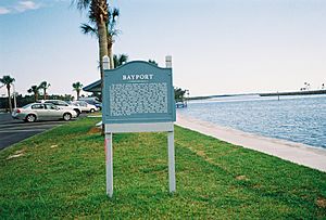
Historic plaque in Bayport
|
|

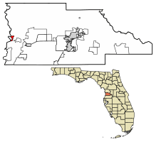
Location of Bayport in Hernando County, Florida.
|
|
| Country | United States |
| State | Florida |
| County | Hernando |
| Area | |
| • Total | 0.64 sq mi (1.67 km2) |
| • Land | 0.57 sq mi (1.49 km2) |
| • Water | 0.07 sq mi (0.18 km2) |
| Elevation | 3 ft (1 m) |
| Population
(2020)
|
|
| • Total | 45 |
| • Density | 78.26/sq mi (30.24/km2) |
| Time zone | UTC-5 (Eastern (EST)) |
| • Summer (DST) | UTC-4 (EDT) |
| FIPS code | 12-04250 |
| GNIS feature ID | 0294669 |
Bayport is a small community in Hernando County, Florida, United States. It's known as a census-designated place (CDP), which means it's an area identified by the U.S. Census Bureau for statistical purposes. In 2010, about 43 people lived there. By 2020, the population had grown slightly to 45 people.
Contents
History of Bayport
Bayport started as a small village in the early 1850s. It was located right where the Weeki Wachee River meets the sea. Back then, it was an important port for shipping goods like cotton. For a short time, it was even the main town, or "county seat," for Hernando County. But in 1856, the county seat moved to Brooksville.
Bayport During the Civil War
During the American Civil War, the Union Navy tried to stop goods from entering or leaving Florida. They set up blockades along the coast. Smaller rivers, like the Weeki Wachee, became important for trade. Because of this, Bayport became a target. Between 1862 and 1865, Union ships stopped many "blockade runners" (ships trying to get past the blockade) near Bayport.
There were also several small battles, called skirmishes, between Union soldiers and the Confederate Home Guard (local soldiers) in Bayport. Union troops even marched all the way from Fort Myers to raid the area. Today, you can still see where the Confederate cannons were placed. It's on the wooded point just north of the Bayport fishing pier.
After the War
After the Civil War ended, Bayport continued to be a major shipping point for lumber and farm products from Hernando County. It remained an important transportation hub until 1885. That's when railroad service reached Brooksville, making trains the new way to move goods.
In 2008, the local government worked with the Southwest Florida Water Management District. They rebuilt Bayport's marina and park area. This helped make the area nicer for visitors and locals.
Geography of Bayport
Bayport is located in the western part of Hernando County. It sits right on the Gulf of Mexico. You can find it at these coordinates: 28°32′54″N 82°38′43″W / 28.54833°N 82.64528°W. The main road to Bayport is Cortez Boulevard. This road goes east about 5 miles (8 km) to U.S. Route 19 at Weeki Wachee.
The U.S. Census Bureau says that Bayport covers a total area of about 0.64 square miles (1.7 square kilometers). Most of this area, about 0.57 square miles (1.5 square kilometers), is land. The rest, about 0.07 square miles (0.2 square kilometers), is water. This means about 10.77% of Bayport's total area is water.
Population
| Historical population | |||
|---|---|---|---|
| Census | Pop. | %± | |
| 2020 | 45 | — | |
| U.S. Decennial Census | |||
As of the 2020 census, Bayport had a population of 45 people.
See also
 In Spanish: Bayport para niños

