
Garrison Concourse facts for kids
Quick facts for kids |
|
|
Garrison Concourse
|
|

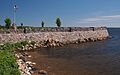
The Garrison Concourse viewed from the south
|
|

Location in Minnesota

Location in the United States
|
|
| Location | Junction of U.S. Route 169 & Minnesota State Highway 18, Garrison, Minnesota |
|---|---|
| Area | 6.3 acres (2.5 ha) |
| Built | 1936–1939 |
| Built by | Civilian Conservation Corps, Minnesota Highway Department |
| Architect | Edward W. Barber (architect), Arthur R. Nichols (landscape architect), Harold E. Olson (engineer) |
| Architectural style | National Park Service rustic |
| MPS | Federal Relief Construction in Minnesota, 1933–1941 |
| NRHP reference No. | 13000882 |
| Designated | December 3, 2013 |
The Garrison Concourse is a special park next to Mille Lacs Lake in Garrison, Minnesota. It's known as a roadside park, which means it's a place where drivers can stop, rest, and enjoy the view.
This park has a big parking area and a beautiful spot to look out over the lake. It also has landscaped areas along the shore. The Garrison Concourse was built between 1936 and 1939. It was a big part of the Mille Lacs Highway Development Plan. This plan was a major project from the New Deal era, which was a time when the U.S. government created many programs to help people during the Great Depression. The goal was to build a scenic road along the lake.
The park was added to the National Register of Historic Places in 2013. This means it's an important historical site for its design and its connection to government projects. It was special because it was the main part of the biggest roadside project ever done by the Minnesota Highway Department and the Civilian Conservation Corps. It also blends two design styles: a formal, organized look and the natural, rustic style of national parks.
Contents
What is the Garrison Concourse Like?

The Garrison Concourse is located on the northwest side of Mille Lacs Lake. This lake is a very popular spot for fishing. The park is right where U.S. Route 169 meets Minnesota State Highway 18. Route 169 connects big cities like Minneapolis–Saint Paul to the northern Iron Range area. Highway 18 leads to Brainerd and other fishing lakes.
The Lake Overlook Area
The main part of the park is the overlook. This is a D-shaped platform that sticks out into the lake. It has a paved driveway and a parking area around a central island. There's also a curved stone walkway around the edge. The platform is about 335 feet (102 meters) long from north to south and 190 feet (58 meters) wide from east to west. It reaches about 160 feet (49 meters) into the lake.
The wall around the overlook is made of large, rough granite blocks. They are laid in a random pattern. The walls are about 2 feet (61 centimeters) thick and stand about 3 feet (0.91 meters) above the inner walkway. Stone pillars, about 3 feet (0.91 meters) tall, are placed at regular spots along the wall. The inner walkway gets wider in three places, giving visitors more room to gather and enjoy the view. A 120-foot (37-meter) wide bay is in the center of the lake-facing side. There are also 70-foot (21-meter) wide bays at both corners closer to the land.
The Central Island and Landscaping
The island in the middle of the overlook was designed with formal gardens and walkways. In the center is a 16-foot (4.9-meter) square stone plaza. This plaza surrounds a stone monument that holds an information plaque and a flagpole.
Some low stone borders, about 6 inches (15 centimeters) high, used to define many parts of the park. Today, only the sections around the central island and a 230-foot (70-meter) stretch along the highway shoulder still remain. You can also see native trees and shrubs planted in the open areas on both sides of the overlook.
Important Features of the Park
When the park was added to the National Register of Historic Places, four parts were considered "contributing properties." This means they are original and important to the park's history. These include the designed landscape itself, the overlook wall, the central monument, and the granite curbing.
Two newer additions are not considered "contributing properties." These are a large fiberglass statue of a walleye fish, put up around 1980, and a small visitor information booth built around 1990.
Why Was the Garrison Concourse Built?
In the early 1900s, Mille Lacs Lake became a popular place for visitors. People first came by train, but then more and more by car. A scenic highway was built along the western shore in 1917. Cars became more affordable for regular families. Mille Lacs Lake was the first big lake people saw when driving north from Minneapolis–Saint Paul.
By the 1920s, the highway along Mille Lacs Lake was the busiest in the state. It gave access to many tourist spots nearby and to places like Brainerd and Aitkin. This road became U.S. Route 169 in 1931.
Helping During the Great Depression
In the 1930s, the Minnesota Highway Department started many big projects. They wanted to improve roads and create scenic rest stops. They used money and workers from the New Deal programs. These programs were created to help people find jobs during the Great Depression.
The goal was to make highways look better, make them safer, and help the growing car tourism industry. These scenic areas gave drivers places to relax, eat, and use restrooms. This was important before gas stations and convenience stores were common.
The Garrison Concourse was designed to be very large. This was to handle many visitors and to match the size of Mille Lacs Lake itself. It is the third largest of over 50 overlooks built by the Minnesota Highway Department during the New Deal. It's also the only one that reaches into a body of water.
How Was the Garrison Concourse Built?
A special camp called the Mille Lacs Lake Highway Wayside Camp (or SP-15) was set up near Garrison. About 200 men from the Civilian Conservation Corps (CCC) lived and worked there. The U.S. Army ran the camp, while the National Park Service and the Minnesota Highway Department guided the work.
Out of 120 CCC camps in Minnesota, only four worked with the Minnesota Highway Department. Camp SP-15 was the longest-running, active for four and a half years, and it achieved the most. The workers were first young men aged 18–25. Later, the camp also hosted older men who were veterans of World War I.
Building the Overlook
Work on the Garrison Concourse started in the spring of 1936. First, they moved a small monument to William Tauer, a local hotel owner who had drowned trying to save people in 1927.
In the summer of 1936, the CCC workers built a cofferdam. This is a temporary wall to hold back lake water. Then, they laid the foundations for the overlook wall. Very hot weather and a need to fight forest fires slowed them down. But by the next year, most of the overlook wall was finished. The overlook plaza was built up with gravel, clay, and stone. The men also created a 350-foot (107-meter) sandy beach north of the overlook. This added to the natural beach on the south side. From 1938 to 1939, workers finished the central plaza, its monument, stonework, benches, and planted trees and shrubs.
Other Projects by Camp SP-15
Besides the Garrison Concourse, Camp SP-15 also widened the highway from two lanes to four for 10 miles (16 kilometers). They also changed a section of the road, built two other wayside rests, and four stone-faced bridges. They also landscaped the areas along the road.
This was less than the original plan to build a scenic highway all around the lake. However, it was still Minnesota's biggest highway development project during the New Deal era. Other projects by Camp SP-15 in the area include the Kenney Lake Overlook, Bridge 5265, Bridge 3355, and the St. Alban's Bay Culvert. Each of these is also listed on the National Register of Historic Places.
Restoring the Park

The Garrison Concourse underwent a big restoration starting in 2011. Over the years, ice and waves had damaged the overlook wall, and the plaza had worn down. The Preservation Alliance of Minnesota had even put it on their 2010 list of "10 most endangered historic places."
The state highway department, now called the Minnesota Department of Transportation (MnDOT), did the repair work. They made sure the work met federal rules for historic properties. Loose stones were put back in place, and missing stones were replaced with similar ones. Some stones that had fallen into the lake were even found and put back into the wall. Repairs were also made to the plaza and the flagpole monument. The walleye statue and information booth, which had been in the middle of the plaza, were moved a short distance away. This made them less noticeable and helped restore the original look of the plaza.
Images for kids
-
The Garrison Concourse viewed from the south
-

The Garrison Concourse's central monument
-
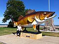
Garrison's giant walleye statue stood here in the middle of the plaza from 1980 to 2013
