
Genoa City, Wisconsin facts for kids
Quick facts for kids
Genoa City, Wisconsin
|
|
|---|---|
|
Village
|
|

Location of Genoa City in Walworth County, Wisconsin
|
|
| Country | United States |
| State | Wisconsin |
| Counties | Kenosha, Walworth |
| Incorporated | October 15, 1901 |
| Renamed | January 24, 1924 |
| Area | |
| • Total | 2.65 sq mi (6.86 km2) |
| • Land | 2.65 sq mi (6.86 km2) |
| • Water | 0.00 sq mi (0.00 km2) |
| Elevation | 830 ft (253 m) |
| Population
(2020)
|
|
| • Total | 2,982 |
| • Density | 1,127.27/sq mi (435.25/km2) |
| Time zone | UTC-6 (Central (CST)) |
| • Summer (DST) | UTC-5 (CDT) |
| ZIP Code |
53128
|
| Area code(s) | 262 |
| FIPS code | 55-28675 |
| GNIS feature ID | 1565461 |
Genoa City is a small village in Wisconsin, USA. It is located in both Kenosha and Walworth counties. The village is about 43 mi (69 km) south of Milwaukee. It sits right on the border between Illinois and Wisconsin. In 2020, about 2,982 people lived there. The village got its name from Genoa, New York, which was named after Genoa in Italy.
Contents
History of Genoa City
The land where Genoa City now stands was bought from the government in 1841. A man named James Dickerson first planned the village. He called it "Genoa" back then. This plan was made in May 1850. Settlers paid $1.25 for each acre of land.
The first two railroad lines were built in the 1850s and 1862. In 1853, a church moved to Genoa City and built a new building. The village's post office was renamed "Genoa Junction" in 1874. On October 15, 1901, the village officially became a town.
By 1880, about 300 people lived in Genoa City. It had many businesses like a hotel, a flour mill, and several stores. In 1884, a fire destroyed many shops on Freeman Street. New buildings were built in the 1890s to replace them. The village's name was officially changed from Genoa Junction to Genoa City on January 24, 1924.
Geography of Genoa City
Genoa City is located at 42°30′13″N 88°19′34″W / 42.50361°N 88.32611°W.
The United States Census Bureau says the village covers about 2.34 square miles (6.06 km2) of land. There is no water area within the village limits.
Population and People
| Historical population | |||
|---|---|---|---|
| Census | Pop. | %± | |
| 1880 | 303 | — | |
| 1910 | 709 | — | |
| 1920 | 656 | −7.5% | |
| 1930 | 683 | 4.1% | |
| 1940 | 715 | 4.7% | |
| 1950 | 866 | 21.1% | |
| 1960 | 1,005 | 16.1% | |
| 1970 | 1,085 | 8.0% | |
| 1980 | 1,202 | 10.8% | |
| 1990 | 1,277 | 6.2% | |
| 2000 | 1,949 | 52.6% | |
| 2010 | 3,042 | 56.1% | |
| 2020 | 2,982 | −2.0% | |
| U.S. Decennial Census | |||
2010 Census Information
In 2010, the village had 3,042 people living there. There were 1,072 households. A household is a group of people living in one home. The population density was about 1,300.0 inhabitants per square mile (501.9/km2). This means there were about 1,300 people per square mile.
Most residents were White (95.4%). About 6.5% of the population was Hispanic or Latino.
About 47.3% of households had children under 18. Many households (55.2%) were married couples living together. The average household had 2.82 people. The average family had 3.29 people.
The average age in the village was 31.9 years. About 32.1% of residents were under 18 years old. About 7.7% were 65 years or older. The population was almost evenly split between males (49.6%) and females (50.4%).
Getting Around
Main Roads
Several important roads pass through or near Genoa City:
 I-43 is about 17 miles (27 km) northwest.
 I-94 is about 20 miles (32 km) east.
 US 12
US 12 WIS 50 is about six miles (9.7 km) north.
- Other county highways like
 CTH-B,
  CTH-H,
  CTH-U,
  CTH-O, and
  CTH-P also serve the area.
Airports Nearby
- Burlington Municipal Airport is in Burlington.
- General Mitchell International Airport in Milwaukee is the closest major airport.
- Westosha Airport is in Wilmot.
Railroads
Currently, there are no railway lines that run through Genoa City. In the past, until 1975, there were two railway lines. These were the Chicago & North Western Williams Bay line and the KD Line.
Images for kids
-
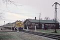
A CNW train at Genoa City in December 1964
.jpg)
See also
 In Spanish: Genoa City (Wisconsin) para niños
