Caddo Mounds State Historic Site facts for kids

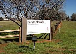
Entrance to Caddo Mound State Historic Site (prior to 2019 tornado)
|
|
| Location | Weeping Mary, Texas |
|---|---|
| Coordinates | 31°35′47″N 95°8′55″W / 31.59639°N 95.14861°W |
| Area | 353 acres (143 ha) |
| History | |
| Founded | 780 CE |
| Abandoned | 1260 CE |
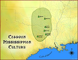
| Cultures | Caddoan Mississippian culture |
| Site notes | |
| Excavation dates | 1919, 1933, 1960s–1980s |
| Archaeologists | James Edwin Pearce, E. B. Sayles, H. Perry Newell |
| Management | Texas Historical Commission |
|
George C. Davis Site
|
|
| NRHP reference No. | 70000742 (original) 79003449 (increase) |
| Significant dates | |
| Added to NRHP | October 15, 1970 |
| Boundary increase | November 15, 1979 |
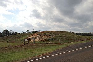
The Caddo Mounds State Historic Site (also called the George C. Davis Site) is an ancient archaeological site in Weeping Mary, Texas. It was once a busy village and special meeting place for the Caddoan Mississippian culture. This site has two large earth platform mounds and one burial mound.
This important settlement grew hundreds of years before Europeans arrived in the area. It was built along an old Native American trail, which the Spanish later called El Camino Real de los Tejas. Experts believe the site was first settled around 800 CE. Most of the big buildings and mounds were constructed between 1100 and 1300 CE.
Today, the Caddo Mounds site is in East Texas, about 6 miles (9.7 km) west of Alto, Texas. It is managed by the Texas Historical Commission. In October 2015, a new museum opened there. Visitors can explore a copy of a Caddo village and enjoy many hands-on exhibits. You can also walk a 0.7 miles (1.1 km) trail to see the burial, low temple, and ceremonial mounds. There is another trail that follows the historic El Camino Real.
Contents
Discovering the Ancient Caddo Village
The Caddo Mounds site began around 850 to 900 CE. The Hasinai people, a Caddo group, moved here from the Red River area. They found a perfect spot for a village. The land had good soil for farming, plenty of food, and a steady water source that flowed into the Neches River.
The Three Mounds of Caddo Mounds
The largest mound, called Mound A, was started around this time. It was at the southern edge of the village and surrounded by about 40 houses. Around 1100 CE, a new mound, Mound B, was started near the center of the site. It grew to be about 175 feet (53 meters) long and 115 feet (35 meters) wide.
Mound C was the northernmost mound. It was used as a burial mound for important people. Mounds A and B were likely used for leaders' homes or temples. This site was the most southwestern ceremonial mound center built by the great mound building cultures of North America.
Why the Caddo Left the Mounds
Around 1250 CE, the local Caddo people ritually covered the mounds. They then moved their main activities from east to west, following their oral history. The smaller villages nearby became more independent. They relied less on the main site for religious and political decisions.
The Caddo culture that remained was similar in many ways. However, it became more equal among people. They also traded for fewer special goods from far away.
Caddo Life and Moving West
By the 1700s, when Europeans first arrived, Caddo groups lived in small villages. These villages were spread out and had their own local leaders.
The Hasinai groups lived in the Neches and Angelina River river valleys until the 1830s. By the early 1840s, all Caddo groups moved to the Brazos River area. They did this to avoid new settlers from America. In 1855, the U.S. government moved them again to the Brazos Indian Reservation. Then, in 1859, they were forced to move to the Washita River in Indian Territory (now western Oklahoma).
Today, most Caddo people live in western Oklahoma. Binger, Oklahoma is the capital of the federally recognized Caddo Nation of Oklahoma.
Exploring the Past: Modern Discoveries
The first written mention of the mounds was in 1779. Athanase de Mézières, a traveler for the Spanish government, recorded them. In 1919, James Edwin Pearce was the first professional archaeologist to study the site. He recorded it for the Smithsonian Institution. In 1933, archaeologist E. B. Sayles confirmed it was a Caddo mound center. He did this by collecting artifacts from the surface.
Early Scientific Digs and Findings
The first scientific excavations happened from 1939 to 1941. H. Perry Newell, a University of Texas archaeologist, led these digs. After Newell passed away, Alex D. Krieger continued the work. He concluded that it was a very important Caddo site. Later excavations in the 1960s and early 1970s by Dee Ann Story helped pinpoint the site's timeline. She found it was active between 780 and 1260 CE.
Creating a Historic Park
In 1974, the Texas Parks and Wildlife Department bought seventy acres of the site. They turned it into a historic park. More excavations happened in the 1970s and 1980s. These were done by the University of Texas at Austin, Texas A&M University, and a private company. As a result, another twenty-three acres were added to the park in 1981.
An interpretive visitors center was built at the site. In 2008, the Texas Historical Commission took over running the property. The museum and members of the Caddo Nation of Oklahoma work together. They create activities to help people understand Caddo culture. For example, in July 2016, an elder named Phil Cross helped build a Caddo grass house using traditional methods.
The 2019 Tornado Event
On April 13, 2019, a powerful EF3 tornado hit the Caddo Mounds. This happened during celebrations for Caddo Culture Day. The tornado caused significant damage to the visitor center and other buildings. The estimated cost of the damage was $2.5 million. Many replica items in the museum were destroyed. However, actual ancient artifacts had been safely removed from public view long before. This was done through an agreement with the Caddo Nation of Oklahoma.
See also


