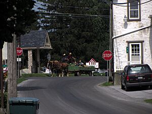
Georgetown, Lancaster County, Pennsylvania facts for kids
Quick facts for kids
Georgetown, Pennsylvania
|
|
|---|---|
 |
|
| Country | United States |
| State | Pennsylvania |
| County | Lancaster |
| Township | Bart |
| Area | |
| • Total | 4.08 sq mi (10.57 km2) |
| • Land | 4.08 sq mi (10.55 km2) |
| • Water | 0.01 sq mi (0.02 km2) |
| Elevation | 678 ft (207 m) |
| Population
(2020)
|
|
| • Total | 1,058 |
| • Density | 259.63/sq mi (100.25/km2) |
| Time zone | UTC-5 (Eastern (EST)) |
| • Summer (DST) | UTC-4 (EDT) |
| ZIP codes | |
| Area code(s) | 717 |
| FIPS code | 42-28828 |
| GNIS feature ID | 1175542 |
Georgetown is a small community in Lancaster County, Pennsylvania, United States. It's known as an unincorporated community and a census-designated place (CDP). This means it's a recognized area for gathering census data, but it doesn't have its own local government like a city or town.
Georgetown is located within Bart Township. In 2010, about 1,022 people lived there. By 2020, the population grew slightly to 1,058. The community has a post office called Bart with the ZIP code 17503. However, the area also uses ZIP codes from nearby towns for different parts of the CDP.
Part of the small community of Nickel Mines is also located within the Georgetown CDP.
Contents
Exploring Georgetown's Location
Georgetown is found in the southern part of Lancaster County. This area is known for having many Amish residents. The community is about 52 miles (84 km) west of Philadelphia.
Main Roads and Travel
Two main roads run through Georgetown: Georgetown Road (Pennsylvania Route 896) and the Christiana Pike (PA Route 372).
- Route 896 goes northwest about 7 miles (11 km) to Strasburg. It also heads southeast about 26 miles (42 km) to Newark, Delaware.
- Route 372 leads east about 5 miles (8 km) to Christiana. It also goes southwest about 6 miles (10 km) to Quarryville.
Geographic Features
The Georgetown CDP covers a total area of about 4.08 square miles (10.6 square kilometers). Most of this area is land, with only a tiny part (about 0.01 square miles or 0.02 square kilometers) being water.
The village of Nickel Mines is located along the northern edge of the CDP. The village of Green Tree is on the southern border. A stream called Nickel Mines Run flows south through the eastern part of Georgetown. This stream is a source for the West Branch of Octoraro Creek. All the water in Georgetown eventually flows into the Susquehanna River.
People Living in Georgetown
The population of Georgetown is counted during the U.S. Decennial Census. This census happens every ten years.
| Historical population | |||
|---|---|---|---|
| Census | Pop. | %± | |
| 2020 | 1,058 | — | |
| U.S. Decennial Census | |||
- In 2010, the population was 1,022 people.
- By 2020, the population had grown to 1,058 people.
See also
In Spanish: Georgetown (condado de Lancaster) para niños


