
Strasburg, Pennsylvania facts for kids
Quick facts for kids
Strasburg, Pennsylvania
|
|||||||||||||||||||||||
|---|---|---|---|---|---|---|---|---|---|---|---|---|---|---|---|---|---|---|---|---|---|---|---|
|
Borough
|
|||||||||||||||||||||||

27 East Main Street, built in 1754
|
|||||||||||||||||||||||
| Etymology: Prince-Bishopric of Strasbourg, Holy Roman Empire | |||||||||||||||||||||||

Location in Lancaster County, Pennsylvania
|
|||||||||||||||||||||||

Strasburg, Pennsylvania
Location in Pennsylvania

Strasburg, Pennsylvania
Location in the United States
|
|||||||||||||||||||||||
| Country | United States | ||||||||||||||||||||||
| State | Pennsylvania | ||||||||||||||||||||||
| County | Lancaster | ||||||||||||||||||||||
| Area | |||||||||||||||||||||||
| • Total | 0.96 sq mi (2.49 km2) | ||||||||||||||||||||||
| • Land | 0.96 sq mi (2.48 km2) | ||||||||||||||||||||||
| • Water | 0.00 sq mi (0.01 km2) | ||||||||||||||||||||||
| Elevation | 463 ft (141 m) | ||||||||||||||||||||||
| Population
(2020)
|
|||||||||||||||||||||||
| • Total | 3,117 | ||||||||||||||||||||||
| • Density | 3,257.05/sq mi (1,256.98/km2) | ||||||||||||||||||||||
| Time zone | UTC-5 (EST) | ||||||||||||||||||||||
| • Summer (DST) | UTC-4 (EDT) | ||||||||||||||||||||||
| ZIP Code |
17579
|
||||||||||||||||||||||
| Area code(s) | 717 and 223 | ||||||||||||||||||||||
|
|||||||||||||||||||||||
Strasburg is a small town, called a borough, in Lancaster County, Pennsylvania, United States. It grew along an old road, the Great Conestoga Road, which later became the Strasburg Road. In 2020, about 3,117 people lived there.
The town got its name from the city of Strasbourg, which was in Germany back then but is now part of France. An early settler from that city named it. Strasburg is often called "Train Town USA" because it has many cool railroad attractions. These include the Strasburg Rail Road and the Railroad Museum of Pennsylvania. Part of the movie Witness was also filmed on a nearby farm. Many buildings in the borough are part of a historic district, recognized in 1983.
Contents
History of Strasburg
The Old Conestoga Road was used as early as 1714. By 1750, a tavern and some log houses were built near where Strasburg is today. The town grew as trade with Philadelphia became more active. By 1759, Strasburg had 32 properties that paid taxes, including about ten hotels.
Many of the first settlers were Huguenots (French Protestants) or Swiss and German Mennonites. Several church groups started in the 1760s. The first church building was built in 1807 by Methodists.
The Old Conestoga Road was the main route connecting Philadelphia to areas further west. However, in 1792, a new toll road called the Philadelphia and Lancaster Turnpike was built. It bypassed Strasburg by about 4 miles to the north. But in 1793, work began on the new Strasburg Road. This road roughly followed the old one and went through West Chester on its way to Philadelphia. People liked this road because it didn't charge tolls, unlike the Philadelphia Turnpike. This road later became Pennsylvania Route 741.
By 1815, Strasburg had 90 houses. About half of them had two stories, showing that many people living there were doing well. There were 53 log houses, 29 brick houses, and four limestone houses. Many of these old houses are still standing today. About 150 other houses in the historic district were built before 1900.
Geography and Location
Strasburg is located in the middle of Lancaster County. Pennsylvania Route 741 (Main Street) runs through the center of town. This road goes east about 9 miles to Gap and west about 5.5 miles to Willow Street. Pennsylvania Route 896 crosses the northeast side of Strasburg. It goes north about 3 miles to U.S. Route 30 and southeast about 20 miles to U.S. Route 1. Lancaster, the main city of the county, is about 8 miles northwest of Strasburg.
The town covers about 1 square mile of land. A very small part, about 0.31%, is water. Strasburg is in the area where water flows into Pequea Creek, which then goes southwest to the Susquehanna River.
Population Facts
| Historical population | |||
|---|---|---|---|
| Census | Pop. | %± | |
| 1840 | 445 | — | |
| 1850 | 880 | 97.8% | |
| 1860 | 921 | 4.7% | |
| 1870 | 1,008 | 9.4% | |
| 1880 | 1,005 | −0.3% | |
| 1890 | 918 | −8.7% | |
| 1900 | 916 | −0.2% | |
| 1910 | 885 | −3.4% | |
| 1920 | 853 | −3.6% | |
| 1930 | 975 | 14.3% | |
| 1940 | 1,706 | 75.0% | |
| 1950 | 1,890 | 10.8% | |
| 1960 | 2,081 | 10.1% | |
| 1970 | 1,897 | −8.8% | |
| 1980 | 1,999 | 5.4% | |
| 1990 | 2,568 | 28.5% | |
| 2000 | 2,800 | 9.0% | |
| 2010 | 2,809 | 0.3% | |
| 2020 | 3,117 | 11.0% | |
| 2021 (est.) | 3,114 | 10.9% | |
| U.S. Decennial Census | |||
In 2000, there were 2,800 people living in Strasburg. This included 1,110 households and 798 families. The town had about 2,714 people per square mile. Most people (97.64%) were White. A small number were African American (0.57%), Native American (0.07%), or Asian (0.86%).
About 34.9% of households had children under 18. The average household had 2.52 people, and the average family had 3.02 people. The median age in Strasburg was 36 years old. This means half the people were younger than 36 and half were older.
Fire Department
The Strasburg Volunteer Fire Company protects the borough of Strasburg. It is also known as Lancaster County Fire Company #5-10, Zone 5. This volunteer fire department is located at 203 Franklin Street. They have a new building with four garage bays. The department uses several vehicles, including:
- one rescue engine
- one engine
- one quint
- one tanker
- one squad
Famous People from Strasburg
- John Alexander Ahl (1813–1882), a congressman
- David Craighead (1924–2012), a famous organ player
- Matt Feiler (born 1992), a football player for the Los Angeles Chargers
- Don Wert (born 1938), a baseball player who won the 1968 World Series with the Detroit Tigers
Education in Strasburg
The schools in Strasburg are part of the Lampeter-Strasburg School District.
Fun Attractions
Strasburg is home to many fun places to visit, especially if you love trains!
- Strasburg Rail Road: Take a ride on a real steam train!
- Choo Choo Barn: See an amazing miniature train display.
- National Toy Train Museum: Learn about the history of toy trains.
- Railroad Museum of Pennsylvania: Explore real trains and railroad history.
- Sight & Sound Theatres: Enjoy live shows with amazing sets and animals.
Images for kids
-
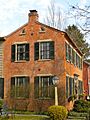
Old brick house on East Main Street
-
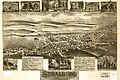
A Bird's-eye view map of Strasburg from 1903
-
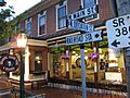
Strasburg Creamery Ice Cream Shoppe
-
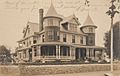
Gonder Mansion in 1906


See also
 In Spanish: Strasburg (Pensilvania) para niños
