Gap, Pennsylvania facts for kids
Quick facts for kids
Gap, Pennsylvania
|
|
|---|---|

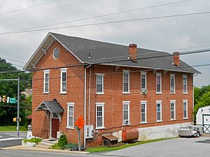
Store in Gap
|
|

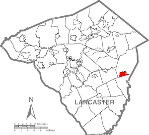
Location in Lancaster County
|
|
| Country | United States |
| State | Pennsylvania |
| County | Lancaster |
| Townships | Salisbury, Sadsbury |
| Area | |
| • Total | 2.91 sq mi (7.52 km2) |
| • Land | 2.90 sq mi (7.52 km2) |
| • Water | 0.00 sq mi (0.01 km2) |
| Elevation | 545 ft (166 m) |
| Population
(2020)
|
|
| • Total | 2,186 |
| • Density | 753.27/sq mi (290.88/km2) |
| Time zone | UTC-5 (Eastern (EST)) |
| • Summer (DST) | UTC-4 (EDT) |
| ZIP code |
17527
|
| Area code(s) | 717 |
| GNIS feature ID | 1175420 |
| FIPS code | 42-28376 |
Gap is a small community in Lancaster County, Pennsylvania. It is called a census-designated place (CDP) because the U.S. Census Bureau tracks its population. In 2020, about 2,186 people lived here.
Gap is located in Salisbury Township. Its ZIP code is 17527. The town is about 16 miles (26 km) east of Lancaster. It is also about 49 miles (79 km) west of Philadelphia.
Several important roads pass through Gap. U.S. Route 30 goes right through the town. Four Pennsylvania highways also start or end here: Route 772, Route 741, Route 897, and Route 41. Route 41 is a busy road that leads towards Wilmington, Delaware.
Contents
History of Gap
Gap got its name because it sits in a low mountain pass. This pass is between Mine Ridge and Gap Hill. The history of Gap goes back to the 1700s. William Penn, who founded Pennsylvania, visited this area early on.
Early Settlements and Mines
The first house in Gap was built in 1747 by Isaac Taylor. The land around Gap was important for its natural resources. There was a copper mine here. At one time, Gap also had the only nickel mines in the entire United States.
The Rising Sun Tavern
From 1792, a famous building called the Rising Sun Tavern stood in Gap. It was on the Philadelphia–Lancaster Pike, which is now U.S. Route 30. The tavern was part of a small village that included a blacksmith shop. Most of these old buildings were taken down around 2020–2021. Now, a large convenience store and gas station are on the site. Many local people wanted to save the old buildings. However, the land was very valuable for new businesses, and there wasn't enough money to preserve them.
Railroad and Transportation
In the 1800s, a railroad line was built through the pass in Gap. Today, this same railroad path is still used. Amtrak trains, part of the Keystone service, travel on these tracks.
The Gap Gang and Local Events
In the mid-1800s, a group known as "The Gap Gang" was active in the area. They were involved in various activities, including conflicts related to the Christiana Riot. This riot was an important event in the history of the fight against slavery.
White Chimneys Estate
Near Gap, there is a historic estate called White Chimneys. It started as a farm owned by a "Church Dutch" family. Later, it became known for its wealth. This was because the Slaymaker family, who owned the Slaymaker Lock Company in Lancaster City, lived there.
Geography of Gap
Gap is located in the eastern part of Lancaster County. It is in the southern section of Salisbury Township. A small part of the community also reaches into Sadsbury Township.
Elevation and Ridges
The "gap" that gives the community its name is about 580 feet (177 meters) above sea level. It is nestled between Mine Ridge to the west and Gap Hill to the east. Both of these ridges rise to about 750 feet (229 meters) above sea level. The town itself is in the middle of this low pass.
Waterways and Watersheds
The community covers about 2.9 square miles (7.5 square kilometers). Only a tiny part of this area is water. The gap separates the water flow for two different creeks. These creeks eventually lead to the Susquehanna River. To the north, streams flow into Pequea Creek. This creek goes west to the Susquehanna River near Pequea. To the south, water flows into the East Branch of Octoraro Creek. This creek reaches the Susquehanna River just south of the Conowingo Dam in Maryland.
Roads and Travel in Gap
Gap is a key spot for travel because several important roads meet here.
U.S. Route 30 (Lincoln Highway)
U.S. Route 30, also known as the Lincoln Highway, runs through Gap. If you go west on US 30, it's about 16 miles (26 km) to Lancaster. If you go east, it's about 10 miles (16 km) to Coatesville. Eventually, this road leads to Philadelphia.
In August 2016, a big project was finished to improve US Route 30. Now, eastbound and westbound traffic are separated in some areas. This has helped to reduce traffic jams that used to happen often.
Pennsylvania Route 41
Pennsylvania Route 41 starts in Gap at US 30. It goes southeast for about 30 miles (48 km) towards the Wilmington, Delaware, area. This route is very important for large commercial trucks.
Pennsylvania Route 772
Pennsylvania Route 772 begins a few blocks west of where PA 41 and US 30 meet. It travels northwest for about 21 miles (34 km) to Lititz. Along the way, it passes through towns like Intercourse, Leola, and Brownstown.
Pennsylvania Route 897
Pennsylvania Route 897 starts in Gap, one block east of Route 41 at US 30. It goes north for about 11 miles (18 km) to Blue Ball. This route crosses over Welsh Mountain.
Pennsylvania Route 741
Pennsylvania Route 741 starts in the center of Gap. It begins at the intersection of PA 41 and Bridge Street. This route heads west for about 19 miles (31 km) to Millersville.
Gap Fire Company
The Gap Fire Co. is located on Pequea Avenue, just west of PA 41. The fire company used to be further up Pequea Avenue. That old building has now been turned into a home. A new, larger building was built to hold all of their rescue trucks.
Population and People
The population of Gap has grown over the years. In 2010, there were 1,931 people living in Gap. By the 2020 census, the population had increased to 2,186 people.
Most of the people living in Gap are White. A small percentage of the population is Asian, Black, or Native American. There are also people of Hispanic or Latino background.
The community has many families. In 2000, about 38.8% of households had children under 18 living with them. The average household had about 2.82 people. The average family had about 3.14 people.
The median age in Gap in 2000 was 36 years old. This means half the people were younger than 36, and half were older. About 29.4% of the population was under 18 years old.
Local Attractions
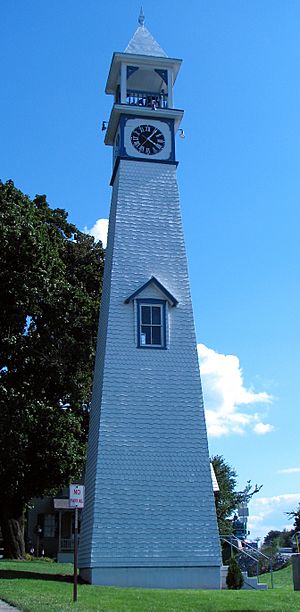
The Gap Town Clock
One of the most interesting attractions in Gap is the Gap Town Clock. It was built in 1892. This clock is considered a Lancaster County Historic Preservation Trust Site. The Gap Clock Tower Association explains that the clock's face has "long telling the time to passing multitudes." It overlooks the spot where William Penn entered what is now Lancaster County in 1701.
Famous People from Gap
- Anne F. Beiler: She is the founder of the popular pretzel company, Auntie Anne's.
- William Chester Ruth (1882–1971): He was an African American inventor and machinist.
- Charles Coates Walker (1920—2004): He was a Quaker activist known for his work for peace and social justice.
See also
 In Spanish: Gap (Pensilvania) para niños
 | Selma Burke |
 | Pauline Powell Burns |
 | Frederick J. Brown |
 | Robert Blackburn |


