
Georgetown, California facts for kids
Quick facts for kids
Georgetown
|
|
|---|---|

1891 Sanborn insurance map of Georgetown
|
|

Location in El Dorado County and the state of California
|
|

Georgetown, California
Location in the United States
|
|
| Country | United States |
| State | California |
| County | El Dorado |
| Area | |
| • Total | 15.132 sq mi (39.193 km2) |
| • Land | 15.128 sq mi (39.182 km2) |
| • Water | 0.004 sq mi (0.011 km2) 0.03% |
| Elevation | 2,654 ft (809 m) |
| Population
(2020)
|
|
| • Total | 2,255 |
| • Density | 149.02/sq mi (57.536/km2) |
| Time zone | UTC-8 (Pacific (PST)) |
| • Summer (DST) | UTC-7 (PDT) |
| ZIP code |
95634
|
| Area code(s) | 530 |
| FIPS code | 06-29350 |
| GNIS feature ID | 1658606 |
| Reference #: | 484 |
Georgetown is a small town in El Dorado County, California, United States. It was once known as Growlersburg. It's located in the northeastern part of California's famous Mother Lode region, known for its gold.
In 2020, about 2,255 people lived in Georgetown. The town is also recognized as California Historical Landmark #484 because of its important history.
Contents
History of Georgetown
Georgetown was founded on August 7, 1849, by a group led by George Phipps. The town got its first nickname, "Growlersburg," because of the heavy, gold-filled quartz rocks. Miners would carry these rocks, and they would "growl" or rumble in their pockets as they walked. The town was later named Georgetown after its founder, George Phipps.
The first post office opened in 1851. In 1852, a big fire destroyed much of the old town. After the fire, the town was rebuilt in a new spot. The planners made Main Street very wide, about 100 feet (30 meters), and the side streets were 60 feet (18 meters) wide. This was very unusual for towns back then! Because of this new design, people called Georgetown the "Pride of the Mountains."
Georgetown was at the center of a very rich gold mining area. Between 1854 and 1856, about three thousand people lived there. Unlike many other gold rush towns, Georgetown lasted a long time. This was because the gold found nearby was in solid rock deposits, not just loose bits in rivers. Gold mining continued in Georgetown even after the year 1900.
During the American Civil War, the people of Georgetown strongly supported the Union. On July 4, 1861, they proudly raised the Stars and Stripes. The flag had the words "Justice and Equality" written on it.
Geography and Climate
Georgetown is a large area, covering about 15.1 square miles (39.1 square kilometers). Most of this area is land.
Understanding Georgetown's Climate
Georgetown has a type of weather called a warm-summer Mediterranean climate. This means it has hot, dry summers and mild, wet winters.
Because of its location in the mountains, Georgetown gets a lot more rain than places in the flat valleys to the west. It gets about four times as much! A small amount of snow falls each year, usually less than 4 inches (10 cm). This snow melts quickly because the temperatures are usually above freezing.
The high rainfall helps plants and trees grow well. However, during the hot, dry summers, this plant life can dry out. This makes wildfires a big risk in the area.
| Climate data for Georgetown, California, 1981–2010 normals | |||||||||||||
|---|---|---|---|---|---|---|---|---|---|---|---|---|---|
| Month | Jan | Feb | Mar | Apr | May | Jun | Jul | Aug | Sep | Oct | Nov | Dec | Year |
| Record high °F (°C) | 76 (24) |
78 (26) |
88 (31) |
88 (31) |
101 (38) |
104 (40) |
107 (42) |
106 (41) |
111 (44) |
100 (38) |
84 (29) |
79 (26) |
111 (44) |
| Mean maximum °F (°C) | 66 (19) |
69 (21) |
72 (22) |
80 (27) |
87 (31) |
96 (36) |
99 (37) |
100 (38) |
97 (36) |
— | — | — | 100 (38) |
| Mean daily maximum °F (°C) | 52.5 (11.4) |
54.1 (12.3) |
58.0 (14.4) |
64.0 (17.8) |
71.2 (21.8) |
81.7 (27.6) |
90.6 (32.6) |
90.7 (32.6) |
85.4 (29.7) |
73.9 (23.3) |
58.3 (14.6) |
50.8 (10.4) |
69.3 (20.7) |
| Daily mean °F (°C) | 44.2 (6.8) |
44.8 (7.1) |
48.1 (8.9) |
52.4 (11.3) |
59.1 (15.1) |
68.7 (20.4) |
76.5 (24.7) |
76.3 (24.6) |
71.2 (21.8) |
61.5 (16.4) |
49.2 (9.6) |
43.1 (6.2) |
57.9 (14.4) |
| Mean daily minimum °F (°C) | 35.9 (2.2) |
35.6 (2.0) |
38.1 (3.4) |
41.1 (5.1) |
46.9 (8.3) |
55.7 (13.2) |
62.4 (16.9) |
62.0 (16.7) |
56.9 (13.8) |
49.2 (9.6) |
39.9 (4.4) |
35.2 (1.8) |
46.6 (8.1) |
| Mean minimum °F (°C) | 24 (−4) |
26 (−3) |
27 (−3) |
30 (−1) |
35 (2) |
41 (5) |
50 (10) |
50 (10) |
43 (6) |
35 (2) |
28 (−2) |
25 (−4) |
21 (−6) |
| Record low °F (°C) | 11 (−12) |
15 (−9) |
15 (−9) |
19 (−7) |
26 (−3) |
31 (−1) |
39 (4) |
39 (4) |
31 (−1) |
23 (−5) |
21 (−6) |
9 (−13) |
9 (−13) |
| Average precipitation inches (mm) | 8.95 (227) |
8.81 (224) |
8.30 (211) |
4.29 (109) |
2.22 (56) |
.69 (18) |
.03 (0.76) |
.07 (1.8) |
.50 (13) |
2.78 (71) |
6.05 (154) |
8.30 (211) |
50.99 (1,296.56) |
| Average snowfall inches (cm) | 2.5 (6.4) |
3.5 (8.9) |
1.9 (4.8) |
0.5 (1.3) |
0.1 (0.25) |
0.0 (0.0) |
0.0 (0.0) |
0.0 (0.0) |
0.0 (0.0) |
0.0 (0.0) |
0.3 (0.76) |
2.9 (7.4) |
11.7 (29.81) |
People of Georgetown
In 2010, the population of Georgetown was 2,367 people. Most residents were White (89.9%). There were also smaller groups of African American, Native American, Asian, and Pacific Islander people. About 7.5% of the population was Hispanic or Latino.
Most people (94.6%) lived in regular homes. About 18.6% of the population was under 18 years old. The average age of people in Georgetown was 46.4 years. For every 100 females, there were about 111 males.
There were 913 households in Georgetown. About 26.5% of these homes had children under 18 living in them. Most homes (57.1%) were occupied by married couples. The average household had 2.45 people.
Education
The schools in Georgetown are part of the Black Oak Mine Unified School District. This district has its main office right in Georgetown.
Notable People
- Ferris Fain
Images for kids
-
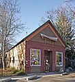
The Armory building, built in Georgetown in 1862 during the American Civil War.

See also
 In Spanish: Georgetown (California) para niños
