Ghaziabad district facts for kids
Ghaziabad district is a busy area in the northern part of Uttar Pradesh state in India. It's a big part of the National Capital Region, which includes Delhi and its surrounding areas. The main city in the district is Ghaziabad, which is also its administrative center. Many people who work in Delhi live here, making it a "bedroom community."
Quick facts for kids
Ghaziabad district
|
|
|---|---|

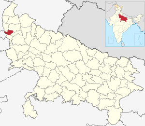
Location of Ghaziabad district in Uttar Pradesh
|
|
| Country | India |
| State | Uttar Pradesh |
| Division | Meerut |
| Headquarters | Ghaziabad |
| Tehsils | 3 |
| Area | |
| • Total | 1,034 km2 (399 sq mi) |
| Population | |
| • Total | 3,406,061 |
| • Density | 3,294.1/km2 (8,532/sq mi) |
| • Urban | 67.55% |
| Demographics | |
| • Literacy | 89% |
| • Sex ratio | 860 (2001) |
| Time zone | UTC+05:30 (IST) |
| Major highways | NH58, NH24, NH91 |
Contents
History of Ghaziabad District
Before 1976, the area we now call Ghaziabad district was actually part of Meerut district. On November 14, 1976, the Chief Minister of Uttar Pradesh, N.D. Tiwari, made it a separate district. At first, it covered an area of 2550 square kilometers.
Changes in District Size
The district's size changed over time. On September 6, 1997, some parts were taken to create Gautam Buddh Nagar district. This reduced Ghaziabad district to 1933 square kilometers. Later, in September 2011, the Hapur area was separated. This created Hapur District, and Ghaziabad district became 1273 square kilometers. Its population was then recorded as 3,323,241 people.
Geography of Ghaziabad
Ghaziabad district is surrounded by several other districts and a state. To the northwest is Baghpat District. To the north is Meerut District. To the east is Hapur District. To the southeast is Bulandshahr District. To the southwest is Gautam Buddha Nagar District. To the west, across the Yamuna River, is Delhi state. The Hindon River also flows through this district.
People and Population (Demographics)
According to the 2011 Census, Ghaziabad is the third most populated district in Uttar Pradesh. It has a population of 4,681,645 people. This number is similar to the population of Ireland. The district ranks 28th in population among all 640 districts in India.
Population Density and Growth
Ghaziabad has a very high population density. There are about 3967 people living in every square kilometer. Between 2001 and 2011, the population grew by 41.66%. After Hapur district was formed, the population was revised to 3,323,241. It has the highest population density in Uttar Pradesh, with 4060 people per square kilometer. The district also has a high population growth rate, increasing by 40.66%.
Literacy and Sex Ratio
The average literacy rate in Ghaziabad district was 85% in 2011. This was the highest literacy rate in Uttar Pradesh at that time. The sex ratio is about 878 females for every 1000 males.
Religions in Ghaziabad
In Ghaziabad district, people from different religions live together. According to the 2011 census, Hindus are the largest group, making up about 73% of the population. Muslims are the second largest group, at 25.4%. About 0.8% of the population are Buddhist, and the remaining 0.8% follow other religions.
Languages Spoken
At the time of the 2011 Census of India, most people in Ghaziabad district spoke Hindi. About 90.96% of the population spoke Hindi as their first language. Urdu was spoken by 7.56% of the people. About 0.49% of the population spoke Punjabi.
See also
 In Spanish: Distrito de Ghaziabad para niños
 | James B. Knighten |
 | Azellia White |
 | Willa Brown |

