Gilbert Seamount facts for kids
Quick facts for kids Gilbert Seamount |
|
|---|---|

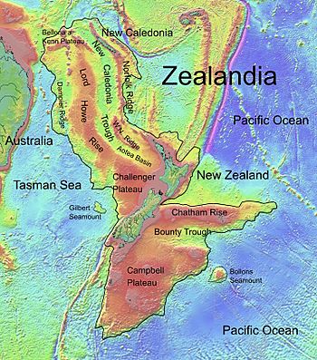
Topographic map of Zealandia, showing Gilbert Seamount
|
|
| Summit depth | 2,400 m (7,900 ft) |
| Location | |
| Location | Tasman Sea |
| Coordinates | 42°52′18.1″S 164°4′0.1″E / 42.871694°S 164.066694°E |
| Country | New Zealand |
| Geology | |
| Type | Seamount (continental fragment) |
Gilbert Seamount is a huge underwater mountain found in the Tasman Sea. It is located about 450 kilometers (280 miles) west of the South Island of New Zealand. This impressive seamount sits at the southern edge of the Lord Howe Rise. It stretches out in a long shape, covering an area of about 11,500 square kilometers (4,400 square miles). Its highest point is 2,400 meters (7,900 feet) below the ocean's surface.
Contents
What is Gilbert Seamount?
Gilbert Seamount is not a volcano, which is what many seamounts are. Instead, it is a special type of seamount called a continental fragment. This means it is a piece of land that broke off from a larger continent.
How Gilbert Seamount Formed
Gilbert Seamount was once part of a supercontinent called Gondwana. Long, long ago, during the Cretaceous period, Gondwana started to break apart. This process is called rifting. As the land pulled apart, Gilbert Seamount separated from areas like the South Tasman Rise and the Challenger Plateau.
Separated by Deep Water
Today, Gilbert Seamount is separated from the Challenger Plateau by a very deep underwater valley. This valley is about 4,400 meters (14,400 feet) deep. This shows just how much the land moved and changed over millions of years.
Other Names for Gilbert Seamount
Over time, this underwater mountain has been known by a few different names. Some people have called it Gilbert Ridge. Others have referred to it as the Gilbert Seamount Complex. It has also been known as Joseph Gilbert Seamount. No matter the name, it remains a fascinating part of our ocean's geography.

