
Gilles Plains, South Australia facts for kids
Quick facts for kids Gilles PlainsAdelaide, South Australia |
|||||||||||||||
|---|---|---|---|---|---|---|---|---|---|---|---|---|---|---|---|

Looking east along Grand Junction Road. Gilles Plains is on the right.
|
|||||||||||||||
| Postcode(s) | 5086 | ||||||||||||||
| LGA(s) | City of Tea Tree Gully | ||||||||||||||
| State electorate(s) | Port Adelaide | ||||||||||||||
| Federal Division(s) | Sturt | ||||||||||||||
|
|||||||||||||||
Gilles Plains is a suburb located in the greater Adelaide area of South Australia. It's about 10 kilometers (or 6 miles) northeast of the main city center of Adelaide. It's a great place to live, with a mix of homes, schools, and shops.
Contents
History of Gilles Plains
How Gilles Plains Got Its Name
Gilles Plains is named after a very important person from early South Australia: Osmond Gilles. He was the first Colonial Treasurer, which means he was in charge of the money for the colony. He owned a large sheep farm near the Torrens River, and Gilles Plains was part of that land.
Farming in Early Gilles Plains
In its early days, Gilles Plains was mostly used for growing hay. Hay is a type of dried grass used to feed animals. In fact, in 1874, the biggest hay farm in all of South Australia was right here in Gilles Plains! It was owned by a person named J. A. W. Sudholz.
Schools in Gilles Plains
Gilles Plains is home to several schools, making it a good place for families.
- Pinnacle College is located on Wandana Avenue.
- St Pauls College can be found on Grand Junction Road.
- Wandana Primary School is on Cowra Avenue, providing education for younger students.
Images for kids
-
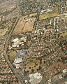
This aerial view shows the western part of Gilles Plains, looking north. Grand Junction Road is at the top, marking the northern edge of the suburb. Sudholz Road on the left is the western boundary. You can see St Paul's College, a TAFE complex, and a shopping center from above.
-
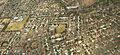
This aerial image shows the northern part of Gilles Plains, also looking north. Grand Junction Road is at the top. St Paul's College is on the left, and Wandana Primary School is near the oval in the middle.


