
Glendale, Wisconsin facts for kids
Quick facts for kids
Glendale, Wisconsin
|
|
|---|---|

The Town of Milwaukee Town Hall, built in 1872 and now a museum.
|
|
| Motto(s):
Rich Past, Bright Future
|
|

Location of Glendale in Milwaukee County, Wisconsin.
|
|
| Country | |
| State | |
| County | Milwaukee |
| Incorporated | December 28, 1950 |
| Area | |
| • Total | 5.96 sq mi (15.45 km2) |
| • Land | 5.76 sq mi (14.93 km2) |
| • Water | 0.20 sq mi (0.52 km2) |
| Elevation | 653 ft (199 m) |
| Population
(2020)
|
|
| • Total | 13,357 |
| • Density | 2,241.1/sq mi (862.5/km2) |
| Time zone | UTC-6 (Central (CST)) |
| • Summer (DST) | UTC-5 (CDT) |
| Area code(s) | 414 |
| FIPS code | 55-29400 |
| GNIS feature ID | 1565570 |
Glendale is a city in Milwaukee County, Wisconsin, United States. It's a suburb located just north of Milwaukee. In 2020, about 13,357 people lived there. Glendale is part of the larger Milwaukee metropolitan area.
Contents
A Look Back at Glendale's History
Glendale has a long and interesting past. People have lived in this area for thousands of years.
Early Inhabitants
The very first known people in the Glendale area were called Woodland period Mound Builders. They created special mounds out of earth. These mounds were used for burials or had shapes of animals, called effigy mounds. Many of these ancient mounds were unfortunately destroyed by farmers between 1850 and 1920. However, you can still find some of them in Kletzsch Park today!
In the early 1800s, Native American tribes lived on this land. These included the Menominee, Potawatomi, and Sauk people. The Menominee tribe gave up their land east of the Milwaukee River to the United States government in 1832. This happened through a special agreement called the Treaty of Washington. A year later, in 1833, the Potawatomi tribe also gave up their land west of the river. They signed the 1833 Treaty of Chicago. This agreement meant they had to leave Wisconsin by 1838.
How Glendale Grew
In 1838, the land became part of the Town of Milwaukee. The first white settlers were mostly farmers. Many of them were immigrants from Germany. One important early community was called Good Hope. It started as a stop for stagecoaches on Green Bay Road in the late 1840s. Good Hope grew into a busy rural community with a tavern, a school, and even a train station.
Glendale officially became a city on December 28, 1950. It was formed from parts of the Town of Milwaukee. This included a busy area with many factories and businesses along Capitol Drive. Glendale began to grow very quickly in the 1950s. This was a time when many cities across the United States were expanding after World War II.
Many new places helped Glendale grow. The Bayshore Town Center (which used to be called Bayshore Mall) opened in 1954. Cardinal Stritch University built its campus in 1959. This campus was located partly in Glendale and partly in the nearby Village of Fox Point. The building of Interstate 43 in the 1950s also helped the city grow even faster. The number of people living in Glendale almost tripled between 1950 and 1960!
Glendale's Modern Look

Unlike some other suburbs near Milwaukee, Glendale has a mix of everything. It has homes, businesses, and industries. The southern parts of the city have more industrial areas and apartments. The northern parts have more houses with bigger yards. Interstate 43 runs through the city, dividing it into east and west sections.
Glendale is working hard to attract new businesses and more people. Major roads have been improved with new designs. Bayshore Town Center has had a huge renovation. The Glendale Business Park continues to welcome new technology companies. In June 2017, the Richard E. Maslowski Glendale Community Park opened. This park has an amphitheater, a playground, a memorial for veterans, a beer garden, and a community room.
Geography of Glendale
Glendale is located at 43°7′48″N 87°55′40″W / 43.13000°N 87.92778°W.
The United States Census Bureau says that the city covers a total area of about 5.97 square miles (15.45 square kilometers). Most of this area, about 5.76 square miles (14.93 square kilometers), is land. The rest, about 0.21 square miles (0.52 square kilometers), is water.
Population and People
| Historical population | |||
|---|---|---|---|
| Census | Pop. | %± | |
| 1960 | 9,537 | — | |
| 1970 | 13,426 | 40.8% | |
| 1980 | 13,882 | 3.4% | |
| 1990 | 14,088 | 1.5% | |
| 2000 | 13,367 | −5.1% | |
| 2010 | 12,872 | −3.7% | |
| 2020 | 13,357 | 3.8% | |
| U.S. Decennial Census | |||
In 2010, there were 12,872 people living in Glendale. There were 5,815 households. About 23.3% of these households had children under 18 living with them. The average household had 2.14 people. The average age of people in the city was 46.8 years old.
Economy and Businesses
Glendale is home to several well-known businesses and attractions:
- Bayshore (shopping mall) - A large shopping center.
- Florsheim Shoes - A company known for its shoes.
- Johnson Controls - A global company that makes smart building technology.
- Sprecher Brewery - A local brewery known for its craft sodas and beers.
- Kopps Frozen Custard - A popular spot for delicious frozen custard.
Education in Glendale
Glendale has several schools and colleges:
- Columbia College of Nursing - A college for nursing students.
- Nicolet High School - This high school serves Glendale and nearby suburbs like Fox Point, Bayside, and River Hills.
- Glen Hills Middle School
Images for kids
-
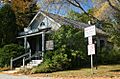
The Town of Milwaukee Town Hall, built in 1872 and now a museum.
-
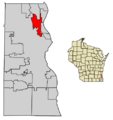
Location of Glendale in Milwaukee County, Wisconsin.
See also
 In Spanish: Glendale (Wisconsin) para niños
