Goondi, Queensland facts for kids
Quick facts for kids GoondiQueensland |
|||||||||||||||
|---|---|---|---|---|---|---|---|---|---|---|---|---|---|---|---|

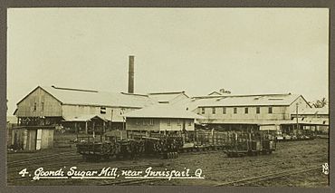
Goondi Sugar Mill, 1930
|
|||||||||||||||
| Population | 28 (2021 census) | ||||||||||||||
| • Density | 9.7/km2 (25/sq mi) | ||||||||||||||
| Postcode(s) | 4860 | ||||||||||||||
| Area | 2.9 km2 (1.1 sq mi) | ||||||||||||||
| Time zone | AEST (UTC+10:00) | ||||||||||||||
| Location |
|
||||||||||||||
| LGA(s) | Cassowary Coast Region | ||||||||||||||
| State electorate(s) | Hill | ||||||||||||||
| Federal Division(s) | Kennedy | ||||||||||||||
|
|||||||||||||||
Goondi is a small rural area in Queensland, Australia. It's part of the Cassowary Coast Region. A "locality" is like a small district or neighborhood. In 2021, only 28 people lived in Goondi, making it a very quiet place. It's mostly known for its farms, especially for growing sugar cane and bananas.
Contents
Exploring Goondi's Landscape
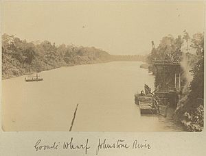
Goondi is located right next to the Johnstone River. The river makes an "elbow" shape around the southern part of Goondi. The land here is very flat, usually only 0 to 10 meters above sea level. This flat land is perfect for farming, which is why you'll see lots of sugar cane and bananas growing.
A creek called Reid Creek flows through Goondi. It starts in the nearby area of Sundown and eventually joins the Johnstone River. There aren't many houses in Goondi; it's mostly farmland.
Major transport routes pass through Goondi. The Bruce Highway, a big road, crosses the Johnstone River here using the Sir Joseph McAvoy Bridge. The North Coast railway line also runs along Goondi's edge and crosses the river. You might also spot a special train track called a "cane train tramway." This is used by farmers to move harvested sugar cane to the local sugar mill.
Goondi's Past: A Look Back
The name "Goondi" comes from an Aboriginal word. It means "elbow," which makes sense because of the elbow-shaped bend in the Johnstone River nearby.
A big part of Goondi's history is its sugar mill. The Goondi Sugar Mill started operating in 1883. It was located near the Johnstone River. During World War 2, there was even an aerial dogfight, a battle between planes, above the mill. A Japanese Zero plane was shot down in the cane fields. At that time, important places like the mill were set up with explosives. The plan was to destroy them if Japanese troops landed, and then people would fight back using guerilla warfare from the Atherton Tablelands.
The mill also had its own dairy that delivered fresh milk every day until the 1960s. The Goondi Sugar Mill eventually closed in 1987 after a company called Bundaberg Sugar took it over.
Goondi Provisional School first opened its doors on 17 February 1898. A "provisional school" was a temporary school. On 1 January 1909, it became Goondi State School, which was a permanent public school. The school was originally located on the south side of Goondi Mill Road. By 1974, it had moved to its current location in Goondi Bend, a neighboring area.
Population of Goondi
In 2016, the population of Goondi was 56 people. By 2021, the population had changed to 28 people.
Learning in Goondi
There are no schools directly within Goondi itself. The closest primary school is Goondi State School, which is located in the nearby area of Goondi Bend. For high school students, the nearest government secondary school is Innisfail State College. This college is found in Innisfail Estate, which is to the east of Goondi.
 | William L. Dawson |
 | W. E. B. Du Bois |
 | Harry Belafonte |


