Johnstone River facts for kids
Quick facts for kids Johnstone |
|
|---|---|

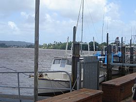
Johnstone River at Innisfail, 2006
|
|
|
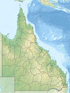
Location of Johnstone River river mouth in Queensland
|
|
| Other name(s) | North Johnstone South Johnstone |
| Country | Australia |
| State | Queensland |
| Region | Far North Queensland, North Queensland |
| City | Innisfail |
| Physical characteristics | |
| Main source | Atherton Tableland |
| 2nd source | North Johnstone River Merivale 760 m (2,490 ft) 17°25′24″S 145°31′25″E / 17.42333°S 145.52361°E |
| 3rd source | South Johnstone River below Mount Father Clancy 755 m (2,477 ft) 17°35′37″S 145°36′32″E / 17.59361°S 145.60889°E |
| River mouth | Coral Sea between Flying Fish Point and Coquette Point 0 m (0 ft) 17°30′39″S 146°04′36″E / 17.51083°S 146.07667°E |
| Length | 200 km (120 mi) |
| Basin features | |
| Basin size | 2,320 km2 (900 sq mi) |
| Tributaries |
|
| Waterfalls | Malanda Falls, Jones Falls, Binda Falls |
| National parks | Ella Bay, Eubenangee Swamp, Herberton Range, Japoon, Malaan, Moresby Range, Palmerston Rocks, Topaz Road, Tully Falls, Tully Gorge and Wooroonooran |
The Johnstone River is a river system in Queensland, Australia. It is made up of two main parts: the North Johnstone River and the South Johnstone River. This river system flows through the Far North and North regions of Queensland.
The Johnstone River starts in the Atherton Tableland area. The North Johnstone River begins near Merivale. It flows past Malanda Falls and through the town of Malanda. It then travels southeast, going around Francis Range and over Jones Falls. This branch is about 114 kilometres (71 mi) long.
The South Johnstone River starts near Mount Father Clancy. It flows east over Binda Falls and through the town of South Johnstone. Then it turns north and is about 88 kilometres (55 mi) long.
The two rivers meet east of Innisfail to form the main Johnstone River. From there, the river flows east, passing north of Moresby Range National Park. Finally, it empties into the Coral Sea.
Together, the Johnstone River system stretches over 200 kilometres (120 mi) from its start to where it meets the sea. It drops about 760 metres (2,490 ft) in height along its path. The area of land that drains into the river, called its catchment area, is about 2,320 square kilometres (900 sq mi). Be careful near the river, as crocodiles live in all parts of the Johnstone River.
Contents
River Journey and Features
The North and South Johnstone Rivers begin in the high tablelands of the tropical coast. They flow through narrow, steep valleys before joining on the flat coastal land near Innisfail. Because these areas get a lot of rain, the rivers can cause big floods. This is especially true around Innisfail.
The North and South Johnstone Rivers together have a catchment area of about 1,600 square kilometres (620 sq mi) at Innisfail. The North Johnstone River is larger, with its own catchment area of about 1,030 square kilometres (400 sq mi).
River Branches and Parks
Important smaller rivers that flow into the North Johnstone River are the North Beatrice River and the Ithaca River. This northern branch is the longest part of the river system. Its waters come from places like the Malanda Falls Conservation Park. They also come from many national parks, including Ella Bay, Eubenangee Swamp, Herberton Range, Japoon, Malaan, Palmerston Rocks, Topaz Road, Tully Falls, Tully Gorge, and Wooroonooran. Malanda Falls is found in the upper part of the North Johnstone River.
The only major smaller river flowing into the South Johnstone River is Downey Creek.
Water Use and Activities
There are no large dams or reservoirs on the Johnstone River. However, people use water from the river for different things. This includes providing water for towns, helping with dairy farming, and growing sugar cane.
The river often experiences floods, like the one on March 8, 2018, which cut off Innisfail from Cairns. Despite this, the Johnstone River is a popular spot for exciting activities. Many people enjoy white-water rafting and other tourist adventures here.
River History
The place where the two main branches of the river meet is very special. It is considered a sacred area by the Indigenous Mamu people.
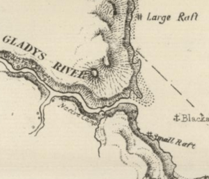
Europeans first explored this area in 1872. Captain John Morseby was looking for people who survived a shipwreck. He named the river the Gladys. Later, in 1873, another explorer named Dalrymple renamed it. He called it the Johnstone River after Sub-Inspector Robert Johnstone. Robert Johnstone was a police officer who was part of both expeditions.
In 1881, the first sugar cane farm and factory were set up in Innisfail. This happened after G. E. Dalrymple said the land along the Johnstone River was good for growing sugar cane.
River Crossings
Jubilee Bridge
The Jubilee Bridge was built across the river in Innisfail in 1923. Before the bridge, people used a ferry service to cross the river. The old Jubilee Bridge was closed in May 2010 because it was found to be unsafe. A new bridge was opened in September 2011. Important people like the Queensland Premier, Anna Bligh, attended the opening ceremony.
Railway and Road Crossings
A railway bridge was built across the North Johnstone River at Daradgee. It opened in December 1924. This bridge was the final link for the North Coast railway line. This line connected the cities of Townsville and Cairns.
The North Johnstone River also has two other crossings. These are located on the Bruce Highway and Shaw Road.
 | Jewel Prestage |
 | Ella Baker |
 | Fannie Lou Hamer |


