Grand View Estates, Colorado facts for kids
Quick facts for kids
Grand View Estates, Colorado
|
|
|---|---|

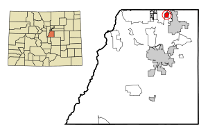
Location of the Grand View Estates CDP in Douglas County, Colorado.
|
|
| Country | |
| State | |
| County | Douglas County |
| Government | |
| • Type | unincorporated community |
| Area | |
| • Total | 1.017 sq mi (2.635 km2) |
| • Land | 0.998 sq mi (2.584 km2) |
| • Water | 0.020 sq mi (0.051 km2) |
| Elevation | 5,817 ft (1,773 m) |
| Population
(2020)
|
|
| • Total | 689 |
| • Density | 677.2/sq mi (261.48/km2) |
| Time zone | UTC-7 (MST) |
| • Summer (DST) | UTC-6 (MDT) |
| ZIP Code |
80134
|
| Area codes | 303 & 720 |
| GNIS feature | Grand View Estates CDP |
Grand View Estates is a small community in Douglas County, Colorado, United States. It is known as an unincorporated community, which means it doesn't have its own local government like a city or town. Instead, it's governed by the county.
It is also a census-designated place (CDP). This is a special area defined by the United States Census Bureau just for counting people. It helps gather information about how many people live in certain areas. Grand View Estates is part of the larger Denver–Aurora–Lakewood, CO Metropolitan Statistical Area, which is a big group of cities and towns around Denver. In 2020, about 689 people lived here. The area uses ZIP code 80134.
Contents
Where is Grand View Estates Located?
Grand View Estates is found in the northern part of Douglas County. It sits between the communities of Stonegate and Parker to its east. To its west, you'll find Lone Tree.
The community is located just south of Exits 2 and 3 on the E-470 toll highway. It is about 20 miles (32 km) south of downtown Denver. The total area of Grand View Estates is about 2.6 square kilometers (1 square mile). A very small part of this area, about 0.05 square kilometers (0.02 square miles), is water.
Who Lives in Grand View Estates?
The United States Census Bureau collects information about people living in different areas every ten years. They first defined Grand View Estates as a CDP for the United States Census 2000.
Here's how the population has changed over the years:
| Grand View Estates CDP, Colorado | ||
|---|---|---|
| Year | Pop. | ±% |
| 2000 | 691 | — |
| 2010 | 528 | −23.6% |
| 2020 | 689 | +30.5% |
| Source: United States Census Bureau | ||
As you can see, the number of people living in Grand View Estates has changed a bit over time. The most recent count in 2020 showed 689 residents.
Schools in the Area
Students living in Grand View Estates attend schools managed by the Douglas County School District RE-1. This school district serves many communities in Douglas County, providing education for children from kindergarten through high school.
See also
 In Spanish: Grand View Estates para niños


