Greenhorn, Oregon facts for kids
Quick facts for kids
Greenhorn, Oregon
|
|
|---|---|

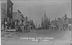
Greenhorn in 1913
|
|

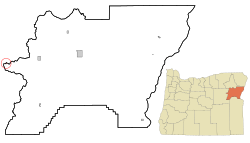
Location in Oregon
|
|
| Country | United States |
| State | Oregon |
| Counties | Baker, Grant |
| Incorporated | 1903 |
| Area | |
| • City | 0.09 sq mi (0.22 km2) |
| • Land | 0.09 sq mi (0.22 km2) |
| • Water | 0.00 sq mi (0.00 km2) |
| Elevation | 6,296 ft (1,919 m) |
| Population
(2020)
|
|
| • City | 3 |
| • Density | 34.88/sq mi (13.47/km2) |
| • Urban | 0 |
| • Metro | 2 |
| Time zone | UTC-8 (Pacific) |
| • Summer (DST) | UTC-7 (Pacific) |
| ZIP code |
97877
|
| Area code(s) | 458 and 541 |
| FIPS code | 41-31050 |
| GNIS feature ID | 2410658 |
Greenhorn is a very small city in Oregon, United States. It has almost no people living there! It sits right on the border between two counties, Baker and Grant, high up in the Blue Mountains. Even though it's in both counties, most people think of it as being in Baker County. This is because its early residents found it easier to do official things in Baker City.
In 2000 and 2010, the city had no residents. By 2020, the population had grown to 3 people.
History of Greenhorn
Greenhorn started in the 1860s. This was when miners came to the area looking for gold. At first, they found gold in rivers and streams (called placer mines). Soon, they also found gold deep underground in veins (called lode gold mines).
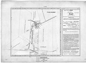
The city was officially planned out in 1904. It became an incorporated city in 1903. This means it got its own local government. In 1910, 28 people lived there. However, between 1900 and 1910, the population dropped by two-thirds. Greenhorn continued as a community until 1942. At that time, gold mining was stopped by a U.S. law during World War II.
Later, the old Greenhorn Jail, built around 1910, was moved to Canyon City. This happened under strange circumstances. A court case tried to get the jail returned. But because Greenhorn is on a county line, the lawyers couldn't even agree which court should hear the case! The case was finally heard in Grant County. The jail is still in Canyon City today.
Greenhorn's Geography
Greenhorn is a very small city. According to the United States Census Bureau, its total area is about 0.22 square kilometers (0.09 square miles). All of this area is land.
The city is located in the Greenhorn Mountains. This is a smaller mountain range inside the larger Blue Mountains. The city is surrounded by two large national forests: the Malheur National Forest and the Wallowa–Whitman National Forest.
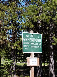
Greenhorn is the highest incorporated city in Oregon. It sits at about 1,919 meters (6,296 feet) above sea level. It's also special because the land for the city was bought directly from the United States government. Usually, land is settled by individuals first.
Population Details
As of the 2000 and 2010 counts, no people were officially living in Greenhorn. However, in 2013, a local newspaper reported that two people lived there all year. The community also had about 13 cabins and 20 people who lived there part-time. By 2020, the official population had increased to 3 people.
See also
 In Spanish: Greenhorn (Oregón) para niños
 | Ernest Everett Just |
 | Mary Jackson |
 | Emmett Chappelle |
 | Marie Maynard Daly |


