
Greenlink Rotary Park Trail System facts for kids
Quick facts for kids Greenlink Rotary Park Trail System |
|
|---|---|

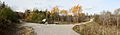
Maillard Street Entrance
|
|
| Lua error in Module:Location_map at line 420: attempt to index field 'wikibase' (a nil value). | |
| Type | Municipal Urban Park |
| Location | Cape Breton Island, Nova Scotia, Canada |
| Nearest town | Sydney |
| Area | 52 acres (21 ha) |
| Created | 15 August 1956 |
| Operated by | Cape Breton Regional Municipality, Parks & Grounds |
| Status | Operational |
| Hiking trails | Greenlink Trails |
| Public transit access | Transit Cape Breton Route 13 |
The Greenlink Rotary Park Trail System is a cool urban park in Sydney, Canada. It's part of Nova Scotia's Cape Breton Regional Municipality. This park is home to the Greenlink Trail System for walking and biking. It also has the Rotary Park Off Leash Park for dogs. Plus, there's a fun disc golf course!
Most of the park is covered in trees. You'll find ponds, a stone dam, and streams there. There are also open grassy areas perfect for playing. The park covers about 52 acres (21 hectares).
The trails connect different parts of Sydney. They link the Shipyard and South End neighborhoods. They also connect to Membertou First Nation and the Cape Breton Regional Hospital. Some trails start from Shandwick Street and the St. Anthony Daniel Ball Park. These trails meet up with the one from Rotary Drive. They cross Churchill Drive and go all the way to the Cape Breton Regional Hospital.
Contents
Awesome Park Features
Explore the Greenlink Trails
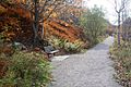
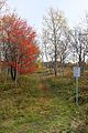
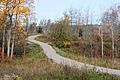
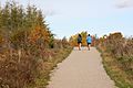
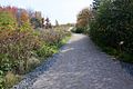
The Greenlink Trail System is made up of paths that are about 2.5 to 3 meters (8 to 10 feet) wide. They are covered with crushed limestone. These paths are great for walking and cycling. However, they aren't suitable for wheelchairs or strollers.
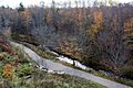
The paths wind through a beautiful natural area. They follow Wentworth Creek, which is now called Reservoir Brook. You'll also see a historic water reservoir with a stone dam and a waterfall. The paths are not lit up at night. You'll find benches along the way if you need to rest. There are also signs and displays to teach you about the park.
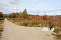
The trail system is about 3 kilometers (1.9 miles) long. Some longer routes, like from Shandwick Street to the Regional Hospital, are about 2.2 kilometers (1.4 miles) one way. You can find parking lots at the Rotary Drive and Churchill Drive entrances.
The paths are kept in good shape. In winter, the parking lots are plowed, but the trails are left with snow. This makes them perfect for snowshoeing or cross-country skiing.

How to Get to the Trails
You can get onto the trail system from several spots:
- The end of Maillard Street in Membertou. It's next to the new rink and Hampton Inn. The address is 51 Maillard St, Membertou, NS B1S 3W4.
- Churchill Drive, where there's a parking area. The address is 425 Churchill Dr, Mira Road, NS B1P 0B1.
- The Cape Breton Regional Hospital, near the staff entrance. The address is 45 Weatherbee Rd, Mira Road, NS B1M 0A1.
- The end of Shandwick Street. The address is 142 Shandwick St, Sydney, NS B1P 4V6.
- Rotary Drive, which also has a parking area. The address is 331 Rotary Dr, Sydney, NS B1P 6L4.
- The Saint Anthony Daniel (Shipyard) Ball Park, just behind the park. There's a parking area here too. The address is 24 Mt Kemmel St, Sydney, NS B1S 3V6.
Fun for Dogs: Off Leash Park
In July 2013, a trial started allowing pets on the trails. Dogs had to be on a leash and with their owners. At the same time, the Rotary Park Off Leash Park was created. This special area is next to the trails and covers over 12 acres (4.9 hectares) of the park.
In July 2014, the dog park became a permanent part of the park. Dogs can now be off leash here. But their owners must always keep them under control. The dog park area isn't fenced. However, it keeps a 30-meter (98-foot) distance from the Greenlink Trails, Rotary Drive, and nearby homes. Signs show where the off-leash area begins and ends.
Play Disc Golf
A nine-hole disc golf course was added to the park in summer 2017. It officially opened on October 25 of that year. All the "holes" are designed as par-3. They have standard disc golf baskets, just like regular golf holes. The course is set in a mix of small hills, trees, and open spaces. Part of the course even shares space with the off-leash dog park.
Like everything else at Greenlink Rotary Park, the disc golf course is free to use. You can get to it near the park gate on Rotary Drive.
Park History: A Look Back in Time
The Old Wentworth Creek Dam

The Wentworth Creek Dam was built a long time ago, between 1892 and 1893. Its main job was to create a water reservoir for the City of Sydney. It provided water for about 2,400 people back then. The dam was made from large, hand-cut stone blocks held together with mortar. It held back the water of Wentworth Creek, which is now called Reservoir Brook. The dam could hold about 6 million imperial gallons (27 million liters) of water.
A large iron pipe was laid along the creek valley. It carried water from the new reservoir to the City of Sydney. By the fall of 1883, the water system was fully working.
By 1901, Sydney was growing fast because of the steel industry. More people meant more demand for water. The Wentworth Dam couldn't supply enough water anymore. So, in 1902, a second dam was built upstream on Sullivan's Brook. This new dam was much bigger. It could hold about 200 million imperial gallons (909 million liters) of water. This dam is located across Highway 125 from the Cape Breton Regional Hospital.
Because the new dam was much higher, its water couldn't easily mix with the Wentworth Dam's supply. So, new, larger water pipes were installed. They connected to the existing pipes further down from Wentworth Dam. This new piping continued along Reservoir Brook and joined Sydney's water system at Cromarty Street.
How Rotary Park Began

To celebrate 50 years of Rotary International, the Rotary Club of Sydney built Rotary Park. The park opened on August 15, 1956. Many people helped make it happen. Rotary volunteers, local businesses, trade unions, and citizens all worked together. The park included the old city reservoir, which was no longer used. This included the Wentworth Creek Dam and its waterfall from the 1880s. This area was turned into a swimming lake. It had diving platforms, a lifeguard stand, and a sandy beach.
The land for Rotary Park was given by people who wanted it to be a community park. These owners included members of St. George's Parish and a Rotarian named C.J. Burchell. Through trades and donations, the land was given to the City of Sydney. A special rule was made: the land must always "remain a park."
This project cost $50,000, which was a lot of money back then! It was one of Sydney's biggest projects. The first part of the park covered 12 acres (4.9 hectares) of the total 52-acre (21-hectare) site. Gordon Elman, the committee chairman, and Alf Reynolds, the Rotary President, were proud to give Rotary Park to the community.
One cool part of the park was a lookout tower. It had a fancy spiral staircase leading to a viewing deck. On a clear day, you could see very far from this tower. You could see the city, the harbor, and even Cape Smokey and the Cape Breton Highlands, which are over 50 kilometers (31 miles) away!

Creating the Greenlink Trail System
The GreenLink Park Society was started in 1997. Their goal was to plan a big natural recreation area in Sydney. It would focus on Rotary Park and include a trail system. This system would connect Sydney's Waterfront Boardwalk and Wentworth Park in downtown Sydney to the Cape Breton Regional Hospital. That's a distance of 3.3 kilometers (2.1 miles). The plan was to add common spaces, small parks, and playgrounds along the route. A company called EDM consulting created a design for the project in December 1998. The GreenLink Park Society then shared the idea with the community.
After a few years of quiet, planning for the Greenlink Park and trail system started again around 2010. The Cape Breton Regional Municipality (CBRM) asked the public for their ideas. By spring 2012, work on the trail system was underway. Rotary Park already had some informal trails, bridges, and other things. But they had fallen apart over time. Earlier, the CBRM had done work in Rotary Park to install new pipes. This included a new sewer for the hospital and a new water main for the city. This work led to repairs and improvements to the existing trails. It also created new access roads and a new stream crossing.
The Greenlink project cost $425,000. It was part of the CBRM's plan to encourage active transportation. The project used these existing routes to create a connected trail system. They improved the old walking trails. They also made them wider and resurfaced them with crushed limestone. The trails are now a standard 2.5 to 3 meters (8 to 10 feet) wide. Benches were put along the paths, and trees were planted. Signs and information panels were also installed. Green Gabion Baskets were placed along parts of the Shandwick Street trail. These act as retaining walls where the ground is steep. Drainage pipes were installed or fixed where needed along the trail. Two parking lots were created, and decorative arches were put at the trail entrances.
The trails officially opened on July 22, 2015. Mayor Cecil Clarke, Membertou Chief Terry Paul, Membertou Band Councillor David Marshall, and CBRM Councillor Eldon MacDonald were all there for the opening.
Gallery
-
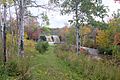
Wentworth Creek Dam and Waterfall
-
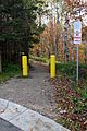
Shandwick Street Entrance
-
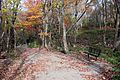
Shandwick Street Trail
-
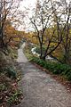
Shandwick Street Trail along Reservoir Brook
-
Shandwick Street Trail
-
Shandwick Street Trail along Reservoir Brook
-
One of the Rotary Park Off Leash Dog Park Entrances off the GreenLink Trails.
-
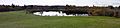
Rotary Park Off Leash Dog Park, Former Reservoir ponds
-

File:24-20131022 Rotary Park GreenLink Trails 0064-66.jpg
-
GreenLink Trails, Sydney, NS
-
Rotary Drive to Regional Hospital Trail
-
St. Anthony Daniel Ball Field to Regional Hospital Trail
-
St. Anthony Daniel Ball Field to Regional Hospital Trail
-
St. Anthony Daniel Ball Field to Regional Hospital Trail


