Grimsay (South East Benbecula) facts for kids
| Gaelic name | Griomasaigh |
|---|---|
| Norse name | Grímsey |
| Meaning of name | "Grim's island", from Norse |
| OS grid reference | NF831473 |
| Coordinates | 57°25′N 7°17′W / 57.41°N 7.28°W |
| Physical geography | |
| Island group | Uist and Barra |
| Area | 117 ha (0.45 sq mi) |
| Area rank | 142 |
| Highest elevation | 20 m (66 ft) |
| Administration | |
| Sovereign state | United Kingdom |
| Country | Scotland |
| Council area | Na h-Eileanan Siar |
| Demographics | |
| Population | 20 |
| Population density | 17 people/km2 |
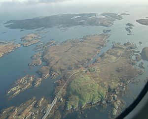
Grimsay is a small, interesting island located in Scotland's Outer Hebrides. It's found just southeast of another island called Benbecula. Grimsay is known as a tidal island. This means that at low tide, you can sometimes walk or drive to it because the water level drops!
Grimsay is connected to Benbecula by a special road called a causeway. This causeway carries the B891 road, making it easy to travel between the two islands. In 2001, only 19 people lived on Grimsay, and by 2011, the population had grown slightly to 20.
Connecting Islands
Grimsay is well-connected to its neighbors. The B891 road doesn't just link Grimsay to Benbecula. It also stretches further southeast. This extension connects Grimsay to another small island called Eilean na Cille.
Peter's Port
This extended road was built to reach a pier at a place called Peter's Port. A pier is like a dock where boats can stop. The pier at Peter's Port was built a long time ago, in 1896.
Even though the pier is there, it can be a bit tricky for boats to use. It's best for sailors to have local knowledge before trying to dock there. This means they should know the area well or get advice from someone who does.
 | Toni Morrison |
 | Barack Obama |
 | Martin Luther King Jr. |
 | Ralph Bunche |


