Grutas de Cacahuamilpa National Park facts for kids
Quick facts for kids Grutas de Cacahuamilpa National Park |
|
|---|---|
|
IUCN Category II (National Park)
|
|
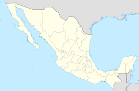
| Location | Guerrero / Morelos, Mexico |
| Nearest city | Taxco, Guerrero |
| Area | 1,600 hectares (4,000 acres) |
| Established | April 23, 1936 |
| Governing body | Secretariat of the Environment and Natural Resources |
The Grutas de Cacahuamilpa National Park in Guerrero, Mexico, is a super cool place! It's most famous for its amazing caves, called the Grutas de Cacahuamilpa Caverns. But there's more to explore!
The park also has a smaller cave system called the Grutas of Carlos Pacheco. Plus, two underground rivers have carved out tunnels in the rock over many years. You can even try exciting outdoor activities like rappelling and rock climbing in Limontitla Canyon. The park also features a small botanical garden, a swimming pool, and places where you can camp.
Contents
Exploring the Park's Geography
The park is nestled in the Sierra Madre del Sur mountains. These mountains are mostly made of limestone rock. This rock formed millions of years ago under ancient oceans. The caves stretch across parts of Guerrero state and even into Morelos state.
The park covers a huge area of over 2,700 hectares (that's about 6,700 acres!). It's located southwest of Mexico City. It's also close to the famous silver-making town of Taxco. This is one of Mexico's most well-known cave systems. About 350,000 people visit the park every year to explore its wonders.
Discover the Grutas de Cacahuamilpa Caves
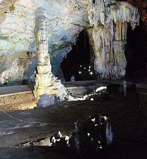
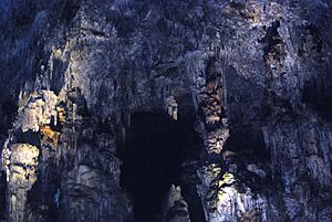
Cacahuamilpa is one of the biggest cave systems in the world! It's called a "live" cave system. This means water still drips into it, and the rock formations are still growing. Inside, there are ninety huge "salons" or rooms. These rooms are separated by natural rock walls. They are all connected by a main pathway.
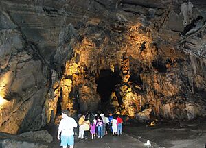
Only about twenty of these rooms are open for visitors. Most of these rooms are under a limestone mountain called Cerro de la Corona. The part you can visit is about two kilometers long. The rooms are usually about forty meters wide. They can be anywhere from twenty to 81 meters tall! Many rooms have fun names. These names come from the shapes of the rocks inside, like the Goat Salon or the Cathedral Salon.
All the rooms have many cool rock formations. These grow from both the ceiling (called stalactites) and the floor (called stalagmites). One of the drier rooms is called the "Auditorium." It has a flat floor and seats. It's used for events and even concerts! Famous singers like Miguel Bosé have performed there.
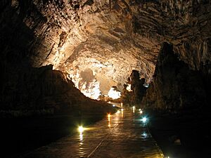
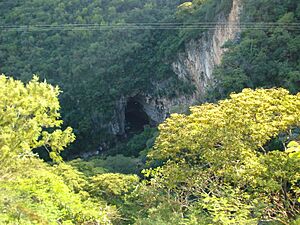
Tours of the open caves happen every hour. Each tour lasts about two hours. Before you enter, you'll see some amate trees. Their roots wrap around the rocky walls of Limontitla Canyon. The cave entrance is a giant arch. It's about forty meters wide and twelve meters tall. From the entrance, you walk down about twenty meters to reach the cave level. The path inside is mostly flat and made of cement. There are lights to help you see the path and the amazing rooms. It can be humid inside because it's a live cave.
People have known about parts of these caves for hundreds of years. They were even used in ancient times! Digs inside the caves have found pieces of pottery. The Olmec people and later the Chontal tribe lived here. Both groups used the caves for special ceremonies. The original name of the caves was "Salachi." The name "Cacahuamilpa" comes from a nearby place. It means "peanut field."
After the Spanish arrived, local people kept the caves a secret. Manuel Sainz de la Peña Miranda is given credit for "discovering" the caves in 1834. He used them to hide from Spanish authorities. This led to a big search of the area. In 1866, Dominik Bilimek and Maximiliano von Habsburg made the first scientific visit to study the cave's living things. The cave was mapped in 1922 and opened to the public soon after. In 1936, President Lázaro Cárdenas made it a national park. Guided tours started in 1969.
In one of the rooms, there's a special gravesite. The story says an Englishman got lost exploring the cave. He eventually passed away. He had a dog with him. He sent the dog for help. But no one outside paid attention to the dog. So, the dog went back to the cave to be with its owner. When their remains were found, they were buried there with rocks and a simple cross.
Explore the Grutas de Carlos Pacheco Caves
The Grutas de Carlos Pacheco are about 400 meters south of the main Cacahuamilpa caves. They are named after Mexican General Carlos Pacheco. He fought against the French in Mexico. Just past the entrance, the cave splits into two paths. Not much water drips into these caves. Parts of them are completely dry. Because of this, it's called a "fossilized cave." The stalagmites and stalactites here stopped growing hundreds of years ago. However, many of these formations are very unusual. Some even look like they are floating! You can visit these caves by arranging a separate tour.
Other Exciting Features of the Park
The park has two underground rivers. One is called the Chontalcoatlán, which is eight kilometers long. The other is the San Jeronimo, which is 12 kilometers long. These rivers are still active. The water keeps slowly carving away at the rock. Both rivers have areas with rocks and sandy beaches along their sides. It gets completely dark in much of these tunnels.
The San Jeronimo River starts from natural springs. Its walls can be up to eighty meters high! Visitors can explore this river. It takes about seven hours to do so. It's the easier of the two to explore because it's more level. The Chontalcoatlán River starts from the Nevado de Toluca volcano. Its path underground has created an entrance fifty meters high. You can also visit this natural tunnel. You need a vehicle to get to its entrance. It's fairly easy to reach a spot called La Caraboya or La Ventana. But after that point, the river goes downhill very steeply. It's not advised for those who aren't in good physical shape. Just after these two rivers come out of the ground, they join together. They form the Amacuazac River.
If you love adventure, rock climbing in this park is highly recommended! There are 45 rock climbing routes. The rocks are mostly limestone with cool stalactites.
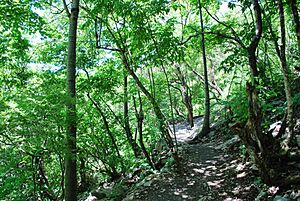
The Limontitla Botanical Garden shows off the native plants of this area. It's a subtropical, mostly deciduous forest. You can explore the garden alone or with a guide. A guide can tell you all about the different plants. The best time to visit is during the rainy season (around June to October). That's when everything is green and blooming!
The park also has a big swimming pool. It's located at a spot that overlooks where the San Jeronimo and Chontalcoatlán Rivers meet. This is where they form the Amacuazac River.
The Park in Popular Culture
Parts of the movie Tarzan and the Valley of Gold were filmed right here in these amazing caverns!
See also
 In Spanish: Parque nacional Grutas de Cacahuamilpa para niños
 | Bayard Rustin |
 | Jeannette Carter |
 | Jeremiah A. Brown |


