Guide Board Corners, New York facts for kids
Quick facts for kids
Guide Board Corners, New York
|
|
|---|---|

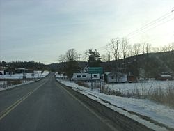
County Route 115 at the intersection with the Old 76 Road in Guide Board Corners. Before 1980, this was the southern terminus of NY 330
|
|
| Country | United States |
| State | New York |
| County | Tompkins |
| Time zone | UTC-5 (Eastern (EST)) |
| • Summer (DST) | UTC-4 (EDT) |
| Website | http://www.townofcaroline.org |
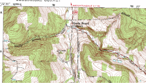
Guide Board Corners is a small community called a hamlet in the town of Caroline, New York, in the United States. It is located where Central Chapel Road, Grove School Road, and Seventy-Six Road meet. Most of Seventy-Six Road is also known as Tompkins County Route 115.
The U.S. Census does not count the population of Guide Board Corners by itself. However, the town of Caroline, where it is located, had 2,910 people living there in the year 2000. Students from Guide Board Corners usually go to schools in nearby Brooktondale. They might also attend schools in other nearby towns or villages.
History of Guide Board Corners
The area around Caroline was first part of Tioga County, New York. This changed in 1817 when Tompkins County was created. Tompkins County then included the area where Guide Board Corners is today.
The community got its name from the first people who settled in the town of Caroline. They named it "Guide Board Corners" because there used to be guide signs at the intersections of Seventy-Six Road and Central Chapel Road. These signs helped travelers find their way.
Education for Students
Like most of the town of Caroline, students from Guide Board Corners attend schools in different areas. Some go to schools within Caroline itself. Others go to school districts in nearby places. These include Dryden, Candor, Ithaca, and Newark Valley.
Getting Around: Transportation
Guide Board Corners can be reached by several roads from other parts of the town. The main road is Central Chapel Road, which is also part of County Route 115. This road runs north to south through the middle of Guide Board Corners. It connects the hamlet to Brooktondale and Slaterville, which are close to New York State Route 79.
The large intersection on Central Chapel Road was once part of New York State Route 330. This state route used to go from Guide Board Corners to Besemer, near NY 79. If you head south from Guide Board Corners on Central Chapel Road, you will reach Brearley Hill.
Another road is Grove School Road, which goes west from Guide Board Corners. It ends where it meets Bald Hill Road. This road is not very long, but it has an interesting history. In 1972, the remains of Hurricane Agnes caused major flooding and damaged bridges in the area. Grove School Road had to be closed. Officials said that roads "were generally awful all over" during that time. Middaugh Road and NY 79 were also closed because of the hurricane.
The last important road in Guide Board Corners is Seventy-Six Road. This road is part of County Route 115. It stretches from Speedsville and the Tioga County line all the way to Guide Board Corners. This part of the road was built between 1804 and 1808. It was originally called "76 Road," but people often called it "Old 76 Road."
 | Delilah Pierce |
 | Gordon Parks |
 | Augusta Savage |
 | Charles Ethan Porter |


