
Gulkana, Alaska facts for kids
Quick facts for kids
Gulkana
C'uul C'ena'
|
|
|---|---|

Location of Gulkana, Alaska
|
|
| Country | United States |
| State | Alaska |
| Census Area | Copper River |
| Area | |
| • Total | 34.88 sq mi (90.35 km2) |
| • Land | 34.88 sq mi (90.35 km2) |
| • Water | 0.00 sq mi (0.00 km2) |
| Population
(2020)
|
|
| • Total | 110 |
| • Density | 3.15/sq mi (1.22/km2) |
| Time zone | UTC−9 (Alaska (AKST)) |
| • Summer (DST) | UTC−8 (AKDT) |
| Area code(s) | 907 |
| FIPS code | 02-30500 |
Gulkana is a small community in Alaska, United States. It is known as a "census-designated place" (CDP). This means it's an area counted by the government for population, but it's not an officially organized city or town.
Gulkana is located in the Copper River Census Area, Alaska. In 2020, about 110 people lived there. The community also has its own airport. The local name for Gulkana in the Ahtna Athabascan language is C'uul C'ena.
Contents
Discover Gulkana's Location and Weather
Gulkana is found at specific coordinates: 62.240213 degrees North and -145.422883 degrees West. The entire area of Gulkana is about 36.5 square miles (94.5 square kilometers). All of this area is land, with no large bodies of water.
What is Gulkana's Climate Like?
Gulkana has a continental subarctic climate. This type of climate means it has very cold, long winters and short, cool summers. It's similar to climates found in parts of Canada or Russia.
| Climate data for Gulkana Airport, Alaska (1991–2020 normals, extremes 1909–present) | |||||||||||||
|---|---|---|---|---|---|---|---|---|---|---|---|---|---|
| Month | Jan | Feb | Mar | Apr | May | Jun | Jul | Aug | Sep | Oct | Nov | Dec | Year |
| Record high °F (°C) | 52 (11) |
53 (12) |
54 (12) |
70 (21) |
85 (29) |
90 (32) |
97 (36) |
88 (31) |
76 (24) |
69 (21) |
48 (9) |
49 (9) |
97 (36) |
| Mean maximum °F (°C) | 33.9 (1.1) |
38.4 (3.6) |
43.1 (6.2) |
56.9 (13.8) |
71.6 (22.0) |
80.7 (27.1) |
80.9 (27.2) |
76.7 (24.8) |
65.5 (18.6) |
53.0 (11.7) |
36.0 (2.2) |
34.8 (1.6) |
83.0 (28.3) |
| Mean daily maximum °F (°C) | 5.0 (−15.0) |
16.1 (−8.8) |
28.0 (−2.2) |
44.4 (6.9) |
58.2 (14.6) |
67.3 (19.6) |
69.3 (20.7) |
64.6 (18.1) |
54.2 (12.3) |
35.9 (2.2) |
15.0 (−9.4) |
7.8 (−13.4) |
38.8 (3.8) |
| Daily mean °F (°C) | −3.4 (−19.7) |
5.6 (−14.7) |
14.7 (−9.6) |
32.6 (0.3) |
45.8 (7.7) |
54.9 (12.7) |
57.9 (14.4) |
53.5 (11.9) |
43.6 (6.4) |
27.1 (−2.7) |
6.8 (−14.0) |
−0.2 (−17.9) |
28.2 (−2.1) |
| Mean daily minimum °F (°C) | −11.7 (−24.3) |
−4.9 (−20.5) |
1.4 (−17.0) |
20.8 (−6.2) |
33.4 (0.8) |
42.5 (5.8) |
46.5 (8.1) |
42.5 (5.8) |
33.1 (0.6) |
18.3 (−7.6) |
−1.4 (−18.6) |
−8.2 (−22.3) |
17.7 (−7.9) |
| Mean minimum °F (°C) | −37.9 (−38.8) |
−29.4 (−34.1) |
−22.9 (−30.5) |
−1.2 (−18.4) |
23.1 (−4.9) |
30.7 (−0.7) |
35.2 (1.8) |
28.3 (−2.1) |
17.1 (−8.3) |
−4.4 (−20.2) |
−24.7 (−31.5) |
−31.4 (−35.2) |
−42.2 (−41.2) |
| Record low °F (°C) | −60 (−51) |
−65 (−54) |
−48 (−44) |
−42 (−41) |
5 (−15) |
22 (−6) |
29 (−2) |
20 (−7) |
2 (−17) |
−23 (−31) |
−45 (−43) |
−65 (−54) |
−65 (−54) |
| Average precipitation inches (mm) | 0.73 (19) |
0.65 (17) |
0.34 (8.6) |
0.22 (5.6) |
0.76 (19) |
1.36 (35) |
1.74 (44) |
1.91 (49) |
1.42 (36) |
1.00 (25) |
0.85 (22) |
0.78 (20) |
11.76 (299) |
| Average snowfall inches (cm) | 9.3 (24) |
10.0 (25) |
3.7 (9.4) |
3.0 (7.6) |
0.6 (1.5) |
trace | 0.0 (0.0) |
0.0 (0.0) |
1.4 (3.6) |
9.8 (25) |
9.9 (25) |
10.7 (27) |
58.4 (148) |
| Average precipitation days (≥ 0.01 inch) | 7.7 | 6.5 | 3.9 | 3.2 | 6.5 | 10.5 | 12.8 | 13.0 | 11.3 | 8.9 | 8.3 | 8.3 | 100.9 |
| Average snowy days (≥ 0.1 inch) | 7.7 | 7.0 | 4.6 | 2.2 | 0.4 | 0.1 | 0.0 | 0.0 | 0.9 | 6.7 | 8.3 | 8.5 | 46.4 |
| Average relative humidity (%) | 73.7 | 76.0 | 69.3 | 65.2 | 58.3 | 60.7 | 65.7 | 68.8 | 72.6 | 79.1 | 79.7 | 76.6 | 70.5 |
| Average dew point °F (°C) | −17.1 (−27.3) |
−2.2 (−19.0) |
5.4 (−14.8) |
19.6 (−6.9) |
27.9 (−2.3) |
38.7 (3.7) |
44.6 (7.0) |
41.7 (5.4) |
34.0 (1.1) |
20.3 (−6.5) |
−0.6 (−18.1) |
−11.9 (−24.4) |
16.7 (−8.5) |
| Source: NOAA (relative humidity and dew point 1961-1990, snowfall and snowy days 1981–2010) | |||||||||||||
- Notes
Understanding Gulkana's Population
Gulkana first appeared in the U.S. Census in 1940 as a small village. Over the years, its population has changed. In 1960, it was listed as Gulkana Reservation. By 1980, it became a census-designated place (CDP).
| Historical population | |||
|---|---|---|---|
| Census | Pop. | %± | |
| 1940 | 25 | — | |
| 1950 | 65 | 160.0% | |
| 1960 | 51 | −21.5% | |
| 1970 | 53 | 3.9% | |
| 1980 | 104 | 96.2% | |
| 1990 | 103 | −1.0% | |
| 2000 | 88 | −14.6% | |
| 2010 | 119 | 35.2% | |
| 2020 | 110 | −7.6% | |
| U.S. Decennial Census | |||
Who Lives in Gulkana?
According to the 2000 census, there were 88 people living in Gulkana. These people lived in 33 different homes, and 19 of these were families. The population density was about 2.4 people per square mile. This means there weren't many people living close together.
Most of the people in Gulkana were Native American (about 71.6%). About 26.1% were White, and a small number were from two or more races.
Families and Age Groups
In 2000, about 36% of homes in Gulkana had children under 18. About 27% of homes were married couples. Some homes (30%) had a female head of household without a husband.
The average age of people in Gulkana was 34 years old. About 35% of the population was under 18. About 29.5% were between 25 and 44 years old.
Income and Financial Well-being
In 2000, the average income for a household in Gulkana was $26,875 per year. For families, the average income was $27,750. The average income per person in Gulkana was $13,548.
About 35% of families and 40% of the total population lived below the poverty line. This included 40% of children under 18.
Images for kids
-
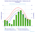
Climate chart for Gulkana
_-_Gulkana_Area,_AK(ThreadEx).svg)
See also
 In Spanish: Gulkana (Alaska) para niños
