
Gunalda facts for kids
Quick facts for kids GunaldaQueensland |
|||||||||||||||
|---|---|---|---|---|---|---|---|---|---|---|---|---|---|---|---|

Gunalda Hotel
|
|||||||||||||||

Gunalda
Location in Queensland
|
|||||||||||||||
| Population | 426 (2021 census) | ||||||||||||||
| • Density | 6.330/km2 (16.39/sq mi) | ||||||||||||||
| Postcode(s) | 4570 | ||||||||||||||
| Area | 67.3 km2 (26.0 sq mi) | ||||||||||||||
| Time zone | AEST (UTC+10:00) | ||||||||||||||
| Location | |||||||||||||||
| LGA(s) |
|
||||||||||||||
| State electorate(s) | Gympie | ||||||||||||||
| Federal Division(s) | Wide Bay | ||||||||||||||
|
|||||||||||||||
Gunalda is a small town in Queensland, Australia. It is a rural area located in the Gympie Region. Part of Gunalda also stretches into the Fraser Coast Region. In 2021, about 426 people lived in Gunalda.
Contents
Where is Gunalda Located?
Gunalda is about 196 kilometers (or 122 miles) away from Brisbane. Brisbane is the capital city of Queensland.
How to Get to Gunalda
The main road, called the Bruce Highway, goes right through Gunalda. It runs from the south-west to the north.
The North Coast railway line also passes near Gunalda. It enters the area from the south-west, near Curra. The railway line then goes to the west of the town and leaves towards the north-west, near Theebine. Years ago, the train line used to go directly through the town. There was even a train station called Gunalda railway station, but it is no longer there.
A Look at Gunalda's History
Gunalda has an interesting past with changes to its name and important buildings.
Early Schools and Post Offices
The first school in the area opened on August 8, 1881. It was called Thompson's Flat Provisional School. In 1889, its name changed to Gunalda Provisional School. Then, on January 1, 1909, it became Gunalda State School.
A post office, first named Eaton Post Office, started on September 1, 1882. It was renamed Gunalda Post Office in 1883.
How Gunalda Got Its Name
The town was first known as Keelar. But on November 2, 1923, the local train station was named Gunalda. After that, the town also changed its name to Gunalda.
Churches in Gunalda
In December 1938, work began on a new Catholic church. On Sunday, October 8, 1939, a special ceremony took place. James Duhig, who was the Archbishop at the time, officially opened the Catholic Church of the Little Flower.
Another church, Christ Church Anglican, was moved to Gunalda in 1947. It came from a place called Munna Creek. This church is now located at 11 King Street in Gunalda. It kept its original name, Christ Church Anglican.
Who Lives in Gunalda?
The number of people living in Gunalda has changed over the years.
- In 2006, about 574 people lived in Gunalda and the areas around it.
- By 2016, the population of Gunalda was about 392 people.
- In the most recent count in 2021, the population grew slightly to 426 people.
Learning in Gunalda
Gunalda has its own primary school for young students.
Gunalda State School
Gunalda State School is a government primary school. It teaches students from Prep (the first year of school) up to Year 6. The school is located on King Street. In 2018, there were 35 students attending the school. They were taught by 3 teachers, and 5 other staff members helped run the school.
Secondary Education Options
There are no high schools directly in Gunalda. Students who are ready for secondary school usually go to James Nash State High School. This school is located in Gympie, which is to the south-east of Gunalda.
Community Facilities
Gunalda has a cemetery for the community.
Gunalda Cemetery
The Gunalda Cemetery is located at the western end of Cotter Drive. It serves as a burial ground for the local community.
Images for kids
-
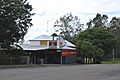
The Gunalda Hotel, a local landmark in the town.
