Hadley, Minnesota facts for kids
Quick facts for kids
Hadley, Minnesota
|
|
|---|---|

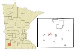
Location in Murray County and the state of Minnesota
|
|
| Country | United States |
| State | Minnesota |
| County | Murray |
| Government | |
| • Type | Mayor − Council |
| Area | |
| • Total | 0.41 sq mi (1.06 km2) |
| • Land | 0.29 sq mi (0.76 km2) |
| • Water | 0.11 sq mi (0.30 km2) |
| Elevation | 1,686 ft (514 m) |
| Population
(2020)
|
|
| • Total | 54 |
| • Density | 183.67/sq mi (70.84/km2) |
| Time zone | UTC-6 (Central (CST)) |
| • Summer (DST) | UTC-5 (CDT) |
| ZIP code |
56151
|
| Area code(s) | 507 |
| FIPS code | 27-26450 |
| GNIS feature ID | 2394266 |
Hadley is a small city in Murray County, Minnesota, in the United States. In 2020, only 54 people lived there, making it a very tiny place! It's known for its quiet, rural setting.
Contents
History of Hadley
Hadley started out with a different name. It was first called "Summit Lake" when it was founded on October 31, 1879.
A year later, in 1880, a post office was opened there, and it was given the name "Hadley." The town officially became a village on September 1, 1903.
Geography of Hadley
Hadley is located in the western part of Murray County. It is surrounded by Leeds Township. The city's coordinates are about 44 degrees North and 95 degrees West.
Minnesota State Highway 30 runs along the southern edge of Hadley. This highway can take you about 5 miles east to Slayton, which is the main town in the county. If you go west on the highway, it's about 23 miles to Pipestone. Murray County Road 29 also goes through the middle of Hadley, running north and south.
The city covers a total area of about 0.41 square miles. Most of this area, about 0.29 square miles, is land. The rest, about 0.11 square miles, is water. A large part of the water area comes from Summit Lake, which is in the southern part of the city.
Population and People in Hadley
| Historical population | |||
|---|---|---|---|
| Census | Pop. | %± | |
| 1880 | 22 | — | |
| 1910 | 136 | — | |
| 1920 | 147 | 8.1% | |
| 1930 | 105 | −28.6% | |
| 1940 | 162 | 54.3% | |
| 1950 | 139 | −14.2% | |
| 1960 | 151 | 8.6% | |
| 1970 | 119 | −21.2% | |
| 1980 | 137 | 15.1% | |
| 1990 | 94 | −31.4% | |
| 2000 | 81 | −13.8% | |
| 2010 | 61 | −24.7% | |
| 2020 | 54 | −11.5% | |
| U.S. Decennial Census | |||
Hadley's Population in 2010
In 2010, the city of Hadley had 61 people living there. These people lived in 32 different homes, and 20 of these were families. The city had about 218 people per square mile of land.
All the people living in Hadley in 2010 were White.
Out of the 32 homes, about 12.5% had children under 18 years old. Half of the homes (50%) were married couples living together. About 12.5% of homes had a female head of household without a husband. The remaining 37.5% were not families.
Almost 38% of all homes had only one person living in them. About 15.6% of these single-person homes had someone 65 years or older living alone. On average, there were about 1.91 people per home and 2.40 people per family.
The average age of people in Hadley in 2010 was 56.2 years old. About 6.6% of residents were under 18. About 9.7% were between 18 and 24. Around 13.2% were between 25 and 44. The largest group, about 40.9%, was between 45 and 64 years old. Finally, about 29.5% of the people were 65 years or older.
When it came to gender, 45.9% of the people in Hadley were male, and 54.1% were female.
See also
 In Spanish: Hadley (Minnesota) para niños
 | Laphonza Butler |
 | Daisy Bates |
 | Elizabeth Piper Ensley |

