Hagan, Georgia facts for kids
Quick facts for kids
Hagan, Georgia
|
|
|---|---|

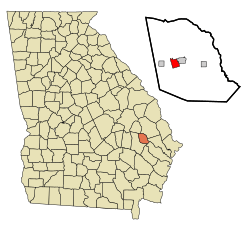
Location in Evans County and the state of Georgia
|
|
| Country | United States |
| State | Georgia |
| County | Evans |
| Area | |
| • Total | 2.15 sq mi (5.58 km2) |
| • Land | 2.04 sq mi (5.30 km2) |
| • Water | 0.11 sq mi (0.28 km2) |
| Elevation | 190 ft (58 m) |
| Population
(2020)
|
|
| • Total | 959 |
| • Density | 469.18/sq mi (181.11/km2) |
| Time zone | UTC-5 (Eastern (EST)) |
| • Summer (DST) | UTC-4 (EDT) |
| ZIP code |
30429
|
| Area code(s) | 912 |
| FIPS code | 13-36024 |
| GNIS feature ID | 0331893 |
Hagan is a city located in Evans County, Georgia, in the United States. In 2020, about 959 people lived in Hagan.
History of Hagan
The state government of Georgia officially made Hagan a city in 1906. The community was named after Susan Hagan. She was the wife of the person who first owned the land where the town was built.
Geography and Location
Hagan is located in the state of Georgia. Its exact spot is 32.155286 degrees North and 81.931872 degrees West.
The city covers about 2.2 square miles (5.58 square kilometers). Most of this area is land, about 2.1 square miles (5.30 square kilometers). A small part, about 0.1 square miles (0.28 square kilometers), is water.
Climate and Weather
Hagan has a warm and humid climate. This means it gets hot and sticky in the summer. In July, the temperature usually reaches about 94 degrees Fahrenheit (34 degrees Celsius). Summer nights are warm, around 70 degrees Fahrenheit (21 degrees Celsius).
Winters are mild, not too cold. In January, the temperature is usually about 61 degrees Fahrenheit (16 degrees Celsius). Winter nights are cool, around 36 degrees Fahrenheit (2 degrees Celsius). It rarely snows or has big winter storms.
| Climate data for Hagan, Georgia | |||||||||||||
|---|---|---|---|---|---|---|---|---|---|---|---|---|---|
| Month | Jan | Feb | Mar | Apr | May | Jun | Jul | Aug | Sep | Oct | Nov | Dec | Year |
| Record high °F (°C) | 81 (27) |
86 (30) |
89 (32) |
96 (36) |
98 (37) |
106 (41) |
107 (42) |
105 (41) |
104 (40) |
96 (36) |
87 (31) |
84 (29) |
107 (42) |
| Mean daily maximum °F (°C) | 61 (16) |
66 (19) |
73 (23) |
78 (26) |
86 (30) |
91 (33) |
94 (34) |
92 (33) |
87 (31) |
80 (27) |
71 (22) |
63 (17) |
79 (26) |
| Mean daily minimum °F (°C) | 36 (2) |
39 (4) |
44 (7) |
50 (10) |
59 (15) |
67 (19) |
71 (22) |
70 (21) |
65 (18) |
54 (12) |
45 (7) |
38 (3) |
53 (12) |
| Record low °F (°C) | −2 (−19) |
13 (−11) |
16 (−9) |
28 (−2) |
41 (5) |
48 (9) |
58 (14) |
56 (13) |
45 (7) |
30 (−1) |
22 (−6) |
13 (−11) |
−2 (−19) |
| Average precipitation inches (mm) | 4.36 (111) |
3.57 (91) |
3.25 (83) |
2.95 (75) |
3.21 (82) |
5.12 (130) |
4.68 (119) |
5.41 (137) |
3.73 (95) |
3.87 (98) |
2.49 (63) |
3.17 (81) |
45.81 (1,165) |
| Source: The Weather Channel | |||||||||||||
Population Changes
| Historical population | |||
|---|---|---|---|
| Census | Pop. | %± | |
| 1910 | 784 | — | |
| 1920 | 356 | −54.6% | |
| 1930 | 431 | 21.1% | |
| 1940 | 685 | 58.9% | |
| 1950 | 525 | −23.4% | |
| 1960 | 552 | 5.1% | |
| 1970 | 572 | 3.6% | |
| 1980 | 880 | 53.8% | |
| 1990 | 787 | −10.6% | |
| 2000 | 898 | 14.1% | |
| 2010 | 996 | 10.9% | |
| 2020 | 959 | −3.7% | |
| U.S. Decennial Census | |||
A census is an official count of the people living in an area. In the year 2000, there were 898 people living in Hagan. These people lived in 362 households, with 229 of them being families. By the 2020 census, the population had grown slightly to 959 people.
See also
 In Spanish: Hagan para niños
 | Emma Amos |
 | Edward Mitchell Bannister |
 | Larry D. Alexander |
 | Ernie Barnes |

