
Hammond Pond Parkway facts for kids

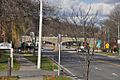
Crossing under Route 9 in Newton
|
|
| Maintained by | Department of Conservation and Recreation |
|---|---|
| Length | 2.0 mi (3.2 km) |
| Location | Hammond Pond Reservation, Massachusetts |
| South end | Newton Street in Brookline |
| Major junctions |
|
| North end | Beacon Street in Newton |
|
Hammond Pond Parkway
|
|

Location in Massachusetts

Location in the United States
|
|
| Location | Chestnut Hill, Massachusetts |
| Area | 14 acres (5.7 ha) |
| Built | 1928 |
| Architect | Eliot, Charles; Olmsted Brothers |
| MPS | Metropolitan Park System of Greater Boston MPS |
| NRHP reference No. | 04000250 |
| Added to NRHP | March 18, 2004 |
Hammond Pond Parkway is a special historic road in Chestnut Hill, Massachusetts. It's called a "parkway" because it was designed to be a beautiful road, often with green spaces and trees around it. This road is about 2 miles (3.2 km) long.
It stretches from Beacon Street in Newton all the way to Horace James Circle in Brookline. Famous landscape designers, Charles Eliot and the Olmsted Brothers, created its design. They wanted to make it easier for people to get from Brookline, Newton, and parts of Boston to the southern parks of the Emerald Necklace. Because of its importance and design, Hammond Pond Parkway was added to the National Register of Historic Places in 2004.
Contents
Exploring the Parkway
This parkway is usually a four-lane road with a paved surface. It starts in the north at Beacon Street. From there, it goes through a lovely natural area. This area includes the Hammond Pond Reservation and the Webster Conservation Area.
Along the way, the parkway crosses over the MBTA Green Line D branch. This used to be a railroad track! Roughly halfway, the parkway reaches a busy intersection with Massachusetts Route 9.
Passing Under Route 9
The parkway actually passes under Route 9. Near this spot, you'll find several shopping centers. These include The Shops at Chestnut Hill and The Street Chestnut Hill.
South of these shopping areas, you'll see a mix of buildings. There are community buildings and homes. Further south, the road goes through a neighborhood with larger houses and big lawns. Finally, the parkway ends at Horace James Circle. This is a big meeting point for several roads, including the West Roxbury Parkway.
History of the Parkway
The idea for Hammond Pond Parkway began a long time ago. People started buying land for the road in 1914. This was based on designs that were drawn up in 1913. More land was bought in 1920, and then again in 1930 and 1931.
When It Was Built
The northern part of the parkway was built first. This section, between Beacon Street and Route 9, was finished in 1931. The southern part of the road was completed the very next year, in 1932.
The M. McDonough Company was in charge of building the parkway. The whole project cost more than $216,000, which was a lot of money back then! Since it was built, only small changes have been made to the parkway. Two important bridges were also built as part of the project. These include the bridge that goes over Route 9 and another bridge over the old railroad tracks.
Main Road Connections
Here are the main roads that connect with Hammond Pond Parkway:
- In Brookline, at the start of the parkway, it connects with Newton Street and Lagrange Street. This is a traffic circle that also leads to the West Roxbury Parkway.
- In Newton, about halfway along the parkway, it connects with Massachusetts Route 9. This is a major interchange with Boylston Street.
- At its northern end in Newton, the parkway connects with Beacon Street.
Images for kids
-
The intersection with Route 9
