Hampstead, Maryland facts for kids
Quick facts for kids
Hampstead, Maryland
|
|||
|---|---|---|---|

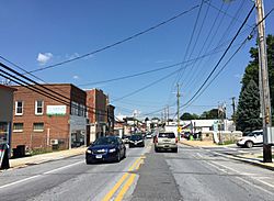
Northbound on Main Street in Hampstead
|
|||
|
|||

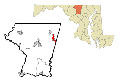
Location of Hampstead, Maryland
|
|||
| Country | United States | ||
| State | Maryland | ||
| County | Carroll | ||
| Incorporated | 1888 | ||
| Area | |||
| • Total | 3.33 sq mi (8.62 km2) | ||
| • Land | 3.30 sq mi (8.55 km2) | ||
| • Water | 0.03 sq mi (0.08 km2) | ||
| Elevation | 928 ft (283 m) | ||
| Population
(2020)
|
|||
| • Total | 6,241 | ||
| • Density | 1,890.64/sq mi (730.09/km2) | ||
| Time zone | UTC-5 (Eastern (EST)) | ||
| • Summer (DST) | UTC-4 (EDT) | ||
| ZIP code |
21074
|
||
| Area code(s) | 410,443 | ||
| FIPS code | 24-36500 | ||
| GNIS feature ID | 0590408 | ||
Hampstead is a friendly town located in Carroll County, in the state of Maryland in the United States. In 2010, about 6,323 people lived here. It's a place with a rich history, growing from a small farming community to a modern town.
Contents
History of Hampstead
Early Beginnings
Between 1736 and 1738, a new road was built from what is now Hanover, Pennsylvania, towards Baltimore County. A small village called Spring Garden became a stop along this road. It was a place where travelers could rest and change horses. This village later grew into the town of Hampstead. The town was named after Hampstead, a famous area in England.
First Settlers and Farmers
The first European settlers in this area were English families. They traveled west from the Port of Philadelphia to find new homes. Later, people from Scotland and Germany also moved to the area. Hampstead became an important center for local farmers. They would come to Hampstead to buy goods brought from Baltimore. They also sent their farm products, like crops, to markets in Baltimore and Pennsylvania from here. The land around Hampstead was flat and good for farming. Farmers also found plenty of lime, which helped their crops grow well.
The Railroad Arrives
In 1879, the Western Maryland Railroad built tracks to Hampstead. This made it much easier to transport goods and people. The railroad helped the town grow and made dairy farming very profitable. More people moved to Hampstead because of the easy access to the railroad.
Hampstead Today
Hampstead officially became a town in 1888. Since then, it has changed a lot. It started as a small farming community and has grown into a modern town with thousands of residents.
Hampstead School's New Life
The Hampstead School is an important historical building. It was added to the National Register of Historic Places in 2002. After being empty and rundown for some time, it was fixed up. Now, it's called The Residences at Hampstead School and serves as a place for older adults to live.
Where is Hampstead?
Hampstead is located at specific coordinates: 39.610303 degrees North and -76.851493 degrees West. This helps pinpoint its exact spot on a map. The town covers an area of about 3.21 square miles (8.31 square kilometers). Most of this area is land, with only a small part being water.
Hampstead is close to several other towns. It is about 3 miles (4.8 kilometers) south of Manchester. It's also about 6 miles (9.7 kilometers) east of Westminster. And if you travel north for about 9 miles (14.5 kilometers), you'll reach Reisterstown.
Who Lives in Hampstead?
| Historical population | |||
|---|---|---|---|
| Census | Pop. | %± | |
| 1860 | 198 | — | |
| 1870 | 235 | 18.7% | |
| 1880 | 306 | 30.2% | |
| 1890 | 521 | 70.3% | |
| 1900 | 480 | −7.9% | |
| 1910 | 555 | 15.6% | |
| 1920 | 566 | 2.0% | |
| 1930 | 905 | 59.9% | |
| 1940 | 664 | −26.6% | |
| 1950 | 677 | 2.0% | |
| 1960 | 696 | 2.8% | |
| 1970 | 961 | 38.1% | |
| 1980 | 1,293 | 34.5% | |
| 1990 | 2,608 | 101.7% | |
| 2000 | 5,060 | 94.0% | |
| 2010 | 6,323 | 25.0% | |
| 2020 | 6,241 | −1.3% | |
| U.S. Decennial Census | |||
Hampstead's Population in 2010
In 2010, the town of Hampstead had 6,323 people living in 2,415 households. A household is a group of people living together in one home. About 1,658 of these households were families.
Most of the people living in Hampstead were White (94.0%). There were also African American, Native American, and Asian residents. About 3.0% of the population identified as Hispanic or Latino.
Many households (42.5%) had children under 18 living with them. More than half (52.8%) were married couples. Some households had a single parent, either a mother (11.4%) or a father (4.5%). About 26.7% of all households were individuals living alone.
The average age of people in Hampstead was about 35 years old. Nearly 30% of residents were under 18. About 10% were 65 years old or older. The town had slightly more females (52.7%) than males (47.3%).
Schools in Hampstead
Hampstead has several schools that serve the town and nearby areas. These include North Carroll Middle School, Shiloh Middle School, Spring Garden Elementary School, and Hampstead Elementary School. These schools help educate the children and young people in the community.
Getting Around Hampstead
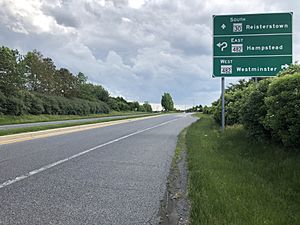
The main way to travel to and from Hampstead is by car on the roads. Maryland Route 30 is the most important highway that goes through the area. It used to go right through the middle of town. Now, it goes around the west side of Hampstead on a "bypass." The old road through town is now called Maryland Route 30 Business.
Maryland Route 30 connects Hampstead to Manchester to the north. It also connects to Reisterstown to the south. Other important roads in Hampstead include Maryland Route 88, Maryland Route 482, and Maryland Route 833.
If you want to travel to downtown Baltimore, you can drive about 20 minutes to the Owings Mills station. This station is part of the Baltimore Metro SubwayLink. From there, you can take the subway directly into the city.
See also
 In Spanish: Hampstead (Maryland) para niños


