Reisterstown, Maryland facts for kids
Quick facts for kids
Reisterstown, Maryland
|
|
|---|---|

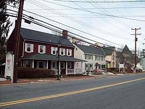
Historic buildings along Reisterstown Road
|
|

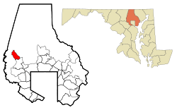
Where Reisterstown is located in Maryland
|
|
| Country | |
| State | |
| County | |
| Settled | 1758 |
| Founded by | John Reister |
| Government | |
| • Type | unincorporated |
| Area | |
| • Total | 5.10 sq mi (13.20 km2) |
| • Land | 5.09 sq mi (13.19 km2) |
| • Water | 0.01 sq mi (0.01 km2) |
| Elevation | 720 ft (220 m) |
| Population
(2020)
|
|
| • Total | 26,822 |
| • Density | 5,267.48/sq mi (2,033.82/km2) |
| Time zone | UTC−5 (Eastern (EST)) |
| • Summer (DST) | UTC−4 (EDT) |
| ZIP codes |
21136, 21071
|
| Area code(s) | 410, 443 |
| FIPS code | 24-65600 |
| GNIS feature ID | 0591112 |
Reisterstown is a community in Maryland, United States. It is located in Baltimore and Carroll counties. As of 2020, about 26,800 people lived there.
A German immigrant named John Reister started Reisterstown in 1758. It is located northwest of Baltimore. Even though it is an old town, many people who work in Baltimore live here.
The old part of Reisterstown is a special historic district. It is listed on the National Register of Historic Places. Other important historic places include the Montrose Mansion and Chapel and St. Michael's Church.
Just north of Reisterstown is Camp Fretterd. This is a training site for the Maryland Army National Guard and Air Guard. The Maryland Defense Force also has its main office there.
Contents
Exploring Reisterstown's Location
Reisterstown covers about 5.1 square miles (13.2 square kilometers) of land.
The community is along Reisterstown Road (Maryland Route 140). It is also near the Northwestern Expressway (Interstate 795). This is just north of Owings Mills.
The northern edge of Reisterstown is near where MD-140 meets Hanover Pike (MD-30). MD-30 goes north towards Hampstead. MD-140 continues northwest as Westminster Pike. It heads towards Finksburg and Westminster.
The community of Glyndon is next to Reisterstown's northern part. It is along Butler Road (MD-128). This road connects Reisterstown to the Baltimore-Harrisburg Expressway (Interstate 83). East of Reisterstown is Worthington, near Greenspring Avenue and Park Heights Avenue (MD-129). To the west is Liberty Reservoir.
A Look at Reisterstown's History
How Reister's Town Began
John Reister bought a piece of land in 1758. He called it "Reister's Desire." He built a tavern there for travelers. This tavern offered food, drinks, and a place to stay.
Soon, other businesses opened to help travelers. This created the settlement known as Reister's Town. Later, it became Reisterstown. John Reister bought more land in 1763. He then developed both sides of Conewago Road, which is now Reisterstown Road.
The Story of Franklin Academy
In 1764, John Reister bought land for the town's first church. It was a small building made of logs. The Lutheran community paid for and built this church. It was open to all religious groups. The building was also used as a school. This was common for churches back then.
In 1824, the town built a new brick school. They named it Franklin Academy, honoring Benjamin Franklin. A cupola was added to the school in 1826. Franklin Academy became the first public high school in the county in 1874. It was one of the first schools to join the Baltimore County school system.
The old Franklin Academy building became a public library in the early 1900s. It is still there, next to the Reisterstown Community Cemetery. It is across the street from the current Franklin Middle School. The cupola from Franklin Academy, called the Franklin Bell, is now in front of Franklin High School.
Who Lives in Reisterstown?
| Historical population | |||
|---|---|---|---|
| Census | Pop. | %± | |
| 1950 | 2,077 | — | |
| 1960 | 4,216 | 103.0% | |
| 1970 | 14,037 | 232.9% | |
| 1980 | 19,385 | 38.1% | |
| 1990 | 19,314 | −0.4% | |
| 2000 | 22,438 | 16.2% | |
| 2010 | 25,968 | 15.7% | |
| 2020 | 26,822 | 3.3% | |
| U.S. Decennial Census | |||
In 2010, about 26,000 people lived in Reisterstown. There were over 10,000 homes. The community is diverse. About 57% of people were White, and 29% were African American. About 6% were Asian, and 9% were Hispanic or Latino.
Many households had children under 18. About 45% were married couples. The average household had about 2.5 people. The average family had about 3 people.
The median age in Reisterstown was 36.2 years. About 27% of the population was under 20 years old. About 10.5% were 65 years or older.
Schools in Reisterstown
Reisterstown has several public and private schools.
Public Schools
- Elementary Schools (Grades K–5):
- Franklin Elementary
- Cedarmere Elementary
- Glyndon Elementary
- Reisterstown Elementary
- Timber Grove Elementary
- Chatsworth Elementary
- Middle School (Grades 6–8):
- Franklin Middle School
- High School (Grades 9–12):
- Franklin High School
Private Schools
- Hannah More School (Grades 9–12)
- Sacred Heart Parochial School (Grades K–8 and preschool)
Getting Around Reisterstown
Many roads help people travel in and out of Reisterstown.
Main Roads
- Butler Road (MD-128)
- Cockeys Mill Road
- Central Avenue
- Deer Park Road
- Dover Road
- Franklin Boulevard
- Hanover Pike (MD-30)
- Ivy Mill Road
- Main Street (MD-140)
- Northwest Expressway (I-795) – This highway connects to the Baltimore Beltway.
- Red Run Boulevard
- Reisterstown Road (MD-140) – This is the main road through the town.
- Sacred Heart Lane
- Westminster Pike (MD-140)
- Worthington Avenue
Fun Activities in Reisterstown
The Reisterstown Area Recreation Council (RRC) plans sports and fun activities.
Reisterstown also has two yearly festivals:
- The Bloomin' ArtsFest: Held in May at Franklin Middle School.
- The Reisterstown Festival: Held in September at Hannah More Park.
Music on Main Street
The Reisterstown Main Street group hosts free concerts. These happen on Friday nights from late spring to early fall. All concerts are at Franklin Middle School (10 Cockeys Mill Road).
Reisterstown Farmers Market
The Reisterstown Farmers Market is open on Sundays. It runs from June 11 to October 29, from 9 AM to 1 PM, rain or shine. It is held outside Franklin Middle School at 120 Main Street. The market features local sellers. They offer things like bread, fresh produce, handmade jewelry, and natural products. You can easily reach it from Main Street, and there is plenty of parking.
See also
 In Spanish: Reisterstown (Maryland) para niños
 | James B. Knighten |
 | Azellia White |
 | Willa Brown |

