Hansel Mountains facts for kids
Quick facts for kids Hansel Mountains |
|
|---|---|
| Highest point | |
| Peak | Unnamed peak on SE ridge |
| Elevation | 6,243 ft (1,903 m) |
| Dimensions | |
| Length | 35 mi (56 km) SW x NE |
| Width | 11 mi (18 km) |
| Geography | |
| Country | United States |
| Communities | Snowville, Utah and Stone, Idaho |
| Topo map | USGS Tremonton, Utah-Idaho, 30x60 minute Quad, USGS, 1989 |
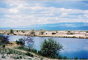
The Hansel Mountains are a cool mountain range in northern Utah. They stretch for about 35 miles (56 kilometers) and are located right near the northern edge of the famous Great Salt Lake.
These mountains are found in the northeast part of Box Elder County. To the southwest, they touch the Locomotive Springs State Wildlife Management Area, which is a special place for wildlife. On the northeast side, the Hansel Mountains connect to the North Hansel Mountains, which are closer to the Utah-Idaho border. The town of Snowville is nearby, located in the Sage Valley. You can even drive through a part of these mountains on Interstate 84. The range continues south, ending at a spot called Monument Point, which offers great views of the Great Salt Lake.
Tallest Spots in the Hansel Mountains
Mountains have different high points, which we call peaks. The very highest spot in the Hansel Mountains doesn't have a specific name. It's an unnamed peak located on the southeast ridge of the range. This peak reaches an elevation of 6,243 feet (1,903 meters) above sea level.
Another important high point is Monument Peak. This peak is located at the southwest end of the mountain range. Monument Peak stands at 5,997 feet (1,828 meters) tall.

 | Roy Wilkins |
 | John Lewis |
 | Linda Carol Brown |


