Haparanda Municipality facts for kids
Quick facts for kids
Haparanda Municipality
Haparanda kommun
|
||
|---|---|---|

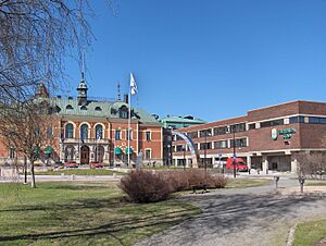
Haparanda Hotel to the left, and the City Hall
|
||
|
||
 |
||
| Country | Sweden | |
| County | Norrbotten County | |
| Seat | Haparanda | |
| Area | ||
| • Total | 1,884.65 km2 (727.67 sq mi) | |
| • Land | 927.26 km2 (358.02 sq mi) | |
| • Water | 957.39 km2 (369.65 sq mi) | |
| Area as of January 1, 2010. | ||
| Population
(June 30, 2012)
|
||
| • Total | 10,064 | |
| • Density | 5.33998/km2 (13.8305/sq mi) | |
| Time zone | UTC+1 (CET) | |
| • Summer (DST) | UTC+2 (CEST) | |
| ISO 3166 code | SE | |
| Province | Norrbotten | |
| Municipal code | 2583 | |
| Website | www.haparanda.se | |
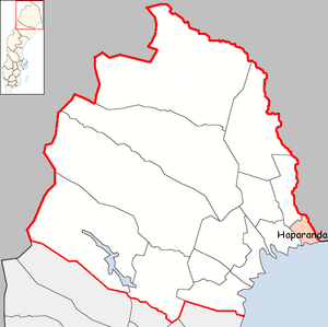
Haparanda Municipality (Swedish: Haparanda kommun) is a special area in northern Sweden. It's located in Norrbotten County. The main town and administrative center is called Haparanda.
In 1967, the "City of Haparanda" joined with two nearby rural areas. Since 1971, Haparanda is a single type of municipality, like all others in Sweden. However, it still likes to call itself a stad (which means "city") for the whole area, even the parts that aren't urban.
Contents
Exploring Haparanda's Geography
Haparanda Municipality is in a unique spot in Sweden. To its north, it shares a border with Övertorneå Municipality. To the west, it borders Kalix Municipality.
Rivers and Borders
Haparanda Municipality sits on the western side of the Torne River. This river flows into the Bay of Bothnia. Right across the river is Tornio, a town in Finland. Haparanda and Tornio work together and even call themselves "EuroCity." This shows how close they are, even though they are in different countries!
Coastal Features
Even though Haparanda has a boat harbor, it's not deep enough for very large ships. It's not the northernmost port in the Baltic Sea; that title likely belongs to Töre, which is further west along the Swedish coast.
Islands and Nature
The municipality includes the Haparanda archipelago. This is a group of 652 islands located in the Bay of Bothnia. It's part of a bigger group of islands called the Norrbotten archipelago.
A special part of these islands is the Haparanda Archipelago National Park. This park includes bigger islands like Sandskär and Seskar Furö, along with many smaller islands and rocky areas. Some other islands in the Haparanda archipelago are Hanhinkari, Kataja, Seskarö, Skomakaren, Stora Hamnskär, Stora Hepokari, and Torne-Furö.
Main Towns and Villages
Haparanda Municipality has five main towns or urban areas. These are the places where most people live:
| # | Locality | Population |
|---|---|---|
| 1 | Haparanda | 4,778 |
| 2 | Marielund | 1,865 |
| 3 | Seskarö | 498 |
| 4 | Nikkala | 447 |
| 5 | Karungi | 232 |
People of Haparanda
Haparanda has a diverse population. Many people living here have family connections from other countries. This is mainly because of its close location to Tornio and Finland. Being right on the border means there's a lot of movement and connections between the two countries.
Sister Cities Around the World
Haparanda has special connections with other cities in different countries. These are called twin towns or sister cities. They often share cultural exchanges and friendly relationships.
Haparanda is twinned with:
 | Anna J. Cooper |
 | Mary McLeod Bethune |
 | Lillie Mae Bradford |


