
Harper Woods, Michigan facts for kids
Quick facts for kids
Harper Woods, Michigan
|
|
|---|---|
| City of Harper Woods | |

Harper Woods Municipal Building
|
|

Location within Wayne County
|
|

Harper Woods, Michigan
Location in Michigan

Harper Woods, Michigan
Location in the United States
|
|
| Country | |
| State | |
| County | Wayne |
| Incorporated | 1951 |
| Government | |
| • Type | Council–manager |
| Area | |
| • City | 2.63 sq mi (6.81 km2) |
| • Land | 2.63 sq mi (6.81 km2) |
| • Water | 0.00 sq mi (0.00 km2) |
| Elevation | 587 ft (179 m) |
| Population
(2020)
|
|
| • City | 15,492 |
| • Density | 5,892.73/sq mi (2,274.79/km2) |
| • Metro | 4,285,832 (Metro Detroit) |
| Time zone | UTC-5 (EST) |
| • Summer (DST) | UTC-4 (EDT) |
| Zip code(s) |
48225
|
| Area code(s) | 313 |
| FIPS code | 26-36700 |
| GNIS feature ID | 0627822 |

Harper Woods is a city located in Wayne County, Michigan, USA. It's a suburb of Detroit, sitting just north and east of the big city. Harper Woods is about 9 miles (14 km) northeast of downtown Detroit. In 2020, about 15,492 people lived there.
Contents
What's in a Name?
The city's name, Harper Woods, has a simple story. It was once a very wooded area. Also, its main street was named Harper Avenue. This avenue was named after Walter Harper, who started Harper Hospital in Detroit.
A Look at Harper Woods' Past
Harper Woods officially became a city on February 19, 1951. Before that, it was part of something called Gratiot Township. After becoming a city, people elected a group to create a city plan. This plan was adopted, and the first city council was chosen. Harper Woods truly began on October 29, 1951, when the city plan started, and the first council members took their oath.
As a new city, Harper Woods faced common challenges. They needed to build schools, streets, sidewalks, and water systems. In 1956, the University of Michigan even studied the city to help it grow.
Harper Woods grew along with the larger Metro Detroit area. In 1955, Interstate 94 (I-94) was approved. This major highway now cuts through the eastern part of the city. Soon after, construction began on the Eastland Shopping Center. Eastland Center, one of the first outdoor malls in the Midwest, opened in 1957. Harper Woods kept developing over the years, and in 2001, the city celebrated its 50th anniversary.
Cultural Highlights
Even though Harper Woods is a newer city, it has some interesting cultural history in the Detroit area.
For many years, the city had the East Side Drive-In. This was the first drive-in theater in Metro Detroit and one of the first in the Midwest! It opened on May 26, 1938. It could hold almost 1,000 cars. The East Side Drive-In closed in 1977 and was torn down a year later.
The Hideout was a very popular teen dance club in the mid-1960s. Many famous Detroit-area musicians played there. These included Bob Seger, Mitch Ryder, Ted Nugent, Glenn Frey (who later joined the Eagles), and Suzi Quatro. The Hideout even started its own local record label, Hideout Records. A CD called Friday at the Hideout was released in 2001, featuring music from bands that played there.
Another place for local bands in the 1960s and 1970s was Notre Dame High School. Many Motown artists would visit and lip-sync their songs. Local bands also got to play live concerts there. Some of the bands that performed included The Amboy Dukes (with Ted Nugent), Bob Seger and the Last Heard, and Frijid Pink.
Harper Woods has been home to some well-known people. These include Betty Bahr (an early TV personality), Leonard H. Bahr (a printer), Helen Filarski (a professional baseball player), Laura Joh Rowland (an author), and Angela Ruggiero (an Olympic ice hockey medalist). Dave Coulier, a popular TV actor, also graduated from Notre Dame High School.
For many years, Eastland Center was a major part of the city's culture and shopping. It featured a famous sculpture called "The Lion and Mouse" by Marshall Fredericks.
Where is Harper Woods?
Harper Woods is located between the City of Detroit and St. Clair Shores. It also sits between Detroit and the Grosse Pointes. On its north side, Harper Woods borders Macomb County along 8 Mile Road. The city is also located along I-94. Eastland Center was the main shopping center until it closed in 2021. Harper Woods does not have train access.
The United States Census Bureau says the city covers about 2.61 square miles (6.81 square kilometers) of land. There is no water area within the city limits.
Schools and Learning
.jpg)
Public Schools
Harper Woods has two public school districts. The Harper Woods School District runs Beacon Elementary School (for preschool to 2nd grade), Tyrone Middle School (3rd-5th grade), Triumph Middle School (6th-8th grade), and Harper Woods High School (9th-12th grade).
Part of Harper Woods is also served by the Grosse Pointe School District. Students in this area attend Charles A. Poupard Elementary School in Harper Woods. For middle and high school, they go to Parcells Middle School and Grosse Pointe North High School in nearby Grosse Pointe Woods. In 2019, Poupard Elementary School was closed because fewer students were attending.
Harper Woods also has charter schools like Chandler Park Academy (Elementary, Middle, and High Schools) and Starr Academy.
Private Schools
Over the years, Harper Woods was home to several private and religious schools that are now closed. These included St. Peter's Grade School, Our Lady Queen of Peace Elementary School, Lutheran High School East, Bishop Gallagher High School, Trinity Catholic High School, Heart Academy, Colin Powell Academy, and Notre Dame High School. Some schools merged, like Bishop Gallagher and St. Florian High School, which became Trinity Catholic High School in Harper Woods in 2002. Both Trinity and Notre Dame closed in 2005. Regina High School, an all-girls school, moved from Harper Woods to Warren in 2007.
College Campuses
The Wayne County Community College has its University Square campus in Harper Woods.
Wayne State University also offers classes at Harper Woods High School in the evenings. These classes often focus on general education subjects.
Public Library
The Harper Woods Public Library serves as the main library for the community.
Who Lives in Harper Woods?
| Historical population | |||
|---|---|---|---|
| Census | Pop. | %± | |
| 1940 | 858 | — | |
| 1950 | 9,148 | 966.2% | |
| 1960 | 19,995 | 118.6% | |
| 1970 | 20,186 | 1.0% | |
| 1980 | 16,361 | −18.9% | |
| 1990 | 14,903 | −8.9% | |
| 2000 | 14,254 | −4.4% | |
| 2010 | 14,236 | −0.1% | |
| 2020 | 15,492 | 8.8% | |
| U.S. Decennial Census 2010 2020 |
|||
In 2020, Harper Woods had a population of 15,492 people. The city has a mix of different backgrounds. About 65.83% of the people were Black or African American, and 27.12% were White. Other groups, including Asian, Native American, and people of mixed races, made up the rest of the population. About 1.94% of the population was Hispanic or Latino.
In 2010, there were 14,236 people living in Harper Woods. The average age in the city was 37.5 years old. About 25.9% of residents were under 18, and 12.8% were 65 or older.
Roads and Highways
 I-94: This major highway runs through the eastern part of Harper Woods. It has two exits in the city: exit 224B (Allard Avenue–Eastwood Drive) and exit 225 (Vernier Road/M-102).
 M-102: This road runs along the northern edge of the city. It is known as 8 Mile Road for a short time before it turns into Vernier Road near I-94.
Images for kids
-
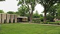
Harper Woods Municipal Building
-
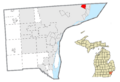
Location within Wayne County
See also
 In Spanish: Harper Woods (Míchigan) para niños
