Harris, Missouri facts for kids
Quick facts for kids
Harris, Missouri
|
|
|---|---|
| City of Harris | |

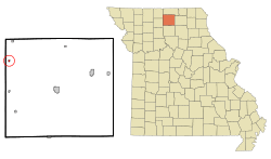
Location of Harris, Missouri
|
|
| Country | United States |
| State | Missouri |
| County | Sullivan |
| Area | |
| • Total | 0.15 sq mi (0.40 km2) |
| • Land | 0.15 sq mi (0.40 km2) |
| • Water | 0.00 sq mi (0.00 km2) |
| Elevation | 909 ft (277 m) |
| Population
(2020)
|
|
| • Total | 65 |
| • Density | 422.08/sq mi (163.02/km2) |
| Time zone | UTC-6 (Central (CST)) |
| • Summer (DST) | UTC-5 (CDT) |
| ZIP code |
64645
|
| Area code(s) | 660 |
| FIPS code | 29-30466 |
| GNIS feature ID | 2396987 |
Harris is a small city located in Sullivan County, Missouri, in the United States. In 2020, about 65 people lived there. It's a quiet place with a friendly community feel.
Contents
A Look Back: Harris's History
Harris was first planned and settled in 1887. The town got its name from A. W. Harris, who was one of the first people to settle in the area. A post office, where people could send and receive mail, also opened in Harris in 1887.
Exploring Harris: Geography and Location
Harris is found in the northwest part of Sullivan County. It sits right next to Missouri Route 139, a main road, and is just west of Medicine Creek. This creek is a natural waterway in the area.
Nearby Towns and Features
If you travel north on Route 139 for about 4.5 miles, you'll reach Newtown. Going south for about seven miles will take you to Osgood. The old Chicago, Milwaukee, St. Paul and Pacific Railroad tracks run along the east side of Harris.
Land Area of Harris
According to the United States Census Bureau, Harris covers a total area of about 0.15 square miles (0.40 square kilometers). All of this area is land, meaning there are no large lakes or rivers within the city limits.
Who Lives in Harris: Population Facts
| Historical population | |||
|---|---|---|---|
| Census | Pop. | %± | |
| 1900 | 336 | — | |
| 1910 | 395 | 17.6% | |
| 1920 | 370 | −6.3% | |
| 1930 | 313 | −15.4% | |
| 1940 | 263 | −16.0% | |
| 1950 | 181 | −31.2% | |
| 1960 | 171 | −5.5% | |
| 1970 | 174 | 1.8% | |
| 1980 | 116 | −33.3% | |
| 1990 | 102 | −12.1% | |
| 2000 | 105 | 2.9% | |
| 2010 | 61 | −41.9% | |
| 2020 | 65 | 6.6% | |
| U.S. Decennial Census | |||
Harris Population in 2010
The census in 2010 counted 61 people living in Harris. These people lived in 30 different homes, and 14 of these were families. The city had about 407 people per square mile.
There were 50 housing units in total. Most residents, about 98.4%, were White. A small number, 1.6%, were from two or more racial backgrounds.
Households and Ages
Out of the 30 homes, about 37% had children under 18 living there. About half of all homes were made up of single individuals. Around 10% of homes had someone living alone who was 65 years old or older.
The average age of people in Harris was about 32.5 years old. About 33% of residents were under 18, and 10% were 65 or older. The population was almost evenly split between males (50.8%) and females (49.2%).
Famous Faces: Notable Person from Harris
- John C. England was an officer in the United States Navy. He was sadly killed during the attack on Pearl Harbor in 1941.
See also
 In Spanish: Harris (Misuri) para niños

