Newtown, Missouri facts for kids
Quick facts for kids
Newtown, Missouri
|
|
|---|---|

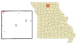
Location of Newtown, Missouri
|
|
| Country | United States |
| State | Missouri |
| County | Sullivan |
| Area | |
| • Total | 0.26 sq mi (0.66 km2) |
| • Land | 0.25 sq mi (0.65 km2) |
| • Water | 0.00 sq mi (0.01 km2) |
| Elevation | 915 ft (279 m) |
| Population
(2020)
|
|
| • Total | 113 |
| • Density | 446.64/sq mi (172.74/km2) |
| Time zone | UTC-6 (Central (CST)) |
| • Summer (DST) | UTC-5 (CDT) |
| ZIP code |
64667
|
| Area code(s) | 660 |
| FIPS code | 29-52328 |
| GNIS feature ID | 2396816 |
Newtown is a small city in Sullivan County, Missouri, United States. It is a quiet community. In 2020, about 113 people lived there.
Contents
Newtown's Story: A Look Back
Newtown was first planned out in 1858. This process is called "platting," which means creating a map of a town's streets and lots. A post office opened in Newtown in 1887. It has been helping people send and receive mail ever since.
Where is Newtown?
Newtown is located in the northwest part of Sullivan County. You can find it along Missouri Route 139. It is also just west of Medicine Creek.
The community of Harris is about 4.5 miles south of Newtown. The town of Lucerne is six miles north in Putnam County. A railroad track, the Chicago, Milwaukee, St. Paul and Pacific Railroad, runs along the east side of Newtown.
The United States Census Bureau says that Newtown covers a total area of about 0.25 square miles (0.65 square kilometers). All of this area is land.
Who Lives in Newtown?
| Historical population | |||
|---|---|---|---|
| Census | Pop. | %± | |
| 1880 | 24 | — | |
| 1890 | 303 | 1,162.5% | |
| 1900 | 291 | −4.0% | |
| 1910 | 261 | −10.3% | |
| 1920 | 408 | 56.3% | |
| 1930 | 284 | −30.4% | |
| 1940 | 285 | 0.4% | |
| 1950 | 231 | −18.9% | |
| 1960 | 265 | 14.7% | |
| 1970 | 211 | −20.4% | |
| 1980 | 170 | −19.4% | |
| 1990 | 115 | −32.4% | |
| 2000 | 209 | 81.7% | |
| 2010 | 183 | −12.4% | |
| 2020 | 113 | −38.3% | |
| U.S. Decennial Census | |||
The population of Newtown has changed over the years. You can see how many people lived there in different census years in the table above.
A Snapshot from 2010
In 2010, the census counted 183 people living in Newtown. These people lived in 74 different homes. About 49 of these homes were families.
The city had about 732 people per square mile. There were 89 housing units in total. Most of the people living in Newtown were White (85.2%). Some residents were Native American (7.7%) or from other races. About 9.8% of the population was Hispanic or Latino.
In 2010, 35.1% of homes had children under 18 living there. Many homes (43.2%) were married couples. About 32.4% of all homes were individuals living alone. The average age of people in Newtown was 36.2 years old. About 31.7% of residents were under 18. Also, 55.7% of the population was male and 44.3% was female.
See also
 In Spanish: Newtown (Misuri) para niños
 | Kyle Baker |
 | Joseph Yoakum |
 | Laura Wheeler Waring |
 | Henry Ossawa Tanner |

