Harris Wash facts for kids
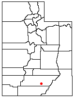
Harris Wash is a long stream that flows into the Escalante River. It is found in Garfield County, in the southern part of Utah, in the western United States. This wash is over 40 miles (about 64 kilometers) long. It shows many cool rock formations, like tall canyon walls and narrow, twisting slot canyons, just like other parts of the Canyons of the Escalante. Harris Wash is a popular spot for outdoor fun and was once an important travel route. It is located inside the Grand Staircase-Escalante National Monument.
The journey of Harris Wash begins high up on the Kaiparowits Plateau. This is a large, flat-topped mountain southwest of the town of Escalante. Several small streams that only flow sometimes (called intermittent streams) join together to form a stream called Alvey Wash. This wash has carved a deep canyon into the plateau over many years. Some of the biggest coal mines in the area are found along this canyon.
Alvey Wash leaves the plateau near its northern end and comes very close to the town of Escalante before turning south. After it passes under the famous Hole-in-the-Rock Road, it changes its name to Harris Wash. From this point, it starts cutting its way through layers of colorful sandstone. By the time Harris Wash reaches the Escalante River, its streambed is more than 400 feet (about 122 meters) lower than the land around it.
Exploring Harris Wash
Harris Wash is a favorite place for people to visit and explore. This is because of its beautiful canyon walls and how easy it is to get to from the town of Escalante. You can usually reach the wash by driving to a trailhead at the end of a side road.
Just below this starting point, the canyon walls get taller, and the stream begins to flow all the time. This means hikers can wade through the water all the way down to where Harris Wash meets the main Escalante River. There are no big obstacles, like huge waterfalls, that block the way into or along the wash. This is why it has been used as a travel route for a very long time.
A Historic Pathway
Harris Wash has an interesting history as a transportation route. In the fall of 1879, a group called the San Juan Expedition created the Hole-in-the-Rock route. They used this difficult path to travel to southeastern Utah, where they planned to start a new settlement. For about a year, they used this route to bring supplies from Escalante. However, they soon realized it was too dangerous and hard to use regularly.
So, in 1881, they found a new, safer way. This new route went down Harris Wash, crossed the Escalante River, then went up Silver Falls Creek. From there, it continued through an area called the Circle Cliffs and eventually crossed the Colorado River at Halls Crossing. This shows how important Harris Wash was for people traveling and settling in this part of Utah long ago.
 | Frances Mary Albrier |
 | Whitney Young |
 | Muhammad Ali |


