
Harvey, Western Australia facts for kids
Quick facts for kids HarveyWestern Australia |
|||||||||
|---|---|---|---|---|---|---|---|---|---|

Stirling Cottage in Harvey
|
|||||||||

Harvey
Location in Western Australia
|
|||||||||
| Established | 1880s | ||||||||
| Postcode(s) | 6220 | ||||||||
| Elevation | 40.3 m (132 ft) | ||||||||
| Area | [convert: needs a number] | ||||||||
| Location |
|
||||||||
| LGA(s) | Shire of Harvey | ||||||||
| State electorate(s) | Murray-Wellington | ||||||||
| Federal Division(s) | Forrest | ||||||||
|
|||||||||
Harvey is a town in the South West region of Western Australia. It is located along the South Western Highway. Harvey is about 140 kilometres (87 miles) south of Perth. It sits between the towns of Pinjarra and Bunbury. The town has a population of 2,797 people. Harvey is well-known for its dairy farms and orange orchards.
Contents
History of Harvey
How Harvey Got Its Name
The town of Harvey gets its name from the nearby Harvey River. Governor James Stirling named the river in 1829. This was soon after explorers Alexander Collie and Lieutenant William Preston discovered it.
The river was most likely named after Rear Admiral John Harvey. He was a naval officer who served in the early 1800s. Governor Stirling had served under him in the navy. Stirling often named places in Western Australia after his old navy friends.
Early Settlement and Growth
In the 1830s, Governor Stirling set up the Harvey River Settlement. He built a hunting lodge near where Harvey town is today. This lodge was called "The Hut." It had jarrah wood walls and a shingled roof. Later, in the 1880s, this hut became the childhood home of famous children's author May Gibbs. Stirling also used the Noongar name "Korijekup" for the area. This name means "place of the red-tailed black cockatoo."
The Harvey area grew slowly during the 1800s. In the 1860s, Australind was the main community in the Harvey District. A road was built from Pinjarra to Brunswick Junction. Convicts helped build this road between 1864 and 1876. It later became the South Western Highway.
Harvey began to develop as a town in the 1890s. This happened after a railway station opened there in 1893. A group of investors helped build up the town. By 1898, Harvey had a population of 93 people. The town was officially declared a townsite in 1938.
Recent Events
In 2006, the company that owned the Harvey Beef brand faced problems. Harvey Beef is a very important business for Western Australia's beef exports. Luckily, a new group of investors saved the brand. They created a new company called Harvey Industries.
In 2010, Harvey gained national attention. A 19-year-old local, Jessica Moloney, became a finalist on Australia's Next Top Model. She finished in fourth place on the show.

Harvey Today
Harvey is the main town of the Shire of Harvey. It is also the heart of Western Australia's dairy industry. The town has a hospital and colleges for agriculture and vocational training. It is home to major businesses like Harvey Fresh, Harvey Beef, and Harvey Cheese.
Every April, Harvey hosts a big agricultural show. The town also has Harvey Senior High School and two primary schools. You can find shops, banks, and places to stay like hotels and caravan parks. The Forest Products Commission's Timber Technology Centre is also in Harvey.
Local Attractions
The old railway station now has a museum. It shows what early life in Harvey was like. There is also a replica of Stirling Cottage. The original cottage fell apart in the 1960s. The new one was built in 1994 and is now a tourist centre and tearoom.
A unique place to visit is the Italian Internment Shrine. Italian people who were held at Harvey No. 11 Camp during World War II built it. It is believed to be one of the only monuments of its kind.
Harvey is also home to Harvey Dam. This dam is a popular spot for fishing and picnics. You can walk all the way across the dam wall. It offers great views and has historical information.
In 2015, a new war memorial was built in Harvey. It shares details about Australians who served in major wars.
Bushfire Event
In January 2016, a large bushfire threatened Harvey. Residents were asked to leave their homes for safety. Patients from the local hospital and people from nursing homes were moved. The fire caused a lot of damage in nearby Yarloop. Luckily, conditions improved, and the town was safe.
Getting Around Harvey
Roads
The main road through Harvey is the South Western Highway. This highway connects Perth to Bunbury. Uduc Road is the main street in Harvey. It leads to the Old Coast Road near Myalup.
Public Transport
Harvey station is on the South Western Railway. The Australind train service stops here twice a day. It travels between Perth and Bunbury.
Transwa and South West Coachlines also run daily bus services. These buses travel between Perth, Mandurah, and Bunbury. They stop near the Harvey Intersection. There is also a private shuttle service that goes to Perth Airport from Harvey. A bus service for senior citizens runs every Friday between Harvey and Bunbury.
Fun Places to Visit
- Stirling Cottage
- Harvey Dam
- The Big Orange Tower and Harvey River Estate Winery
- Harvey Railway Station Museum
- Harvey Internment Camp Memorial Shrine (Harvey No 11 Camp)
- Harvey War Memorial Park
- Harvey River Diversion Enhancement
- Myalup Beach and Binningup Beach
Education in Harvey
Harvey has two primary schools: Harvey Primary School and St Anne's School. For high school, students can attend Harvey Senior High School. There is also the WA College of Agriculture – Harvey. Some students choose to go to high schools in Australind, such as Our Lady of Mercy College or Australind Senior High School.
Climate in Harvey
Harvey has a mediterranean climate. This means it has hot, dry summers and wet winters.
| Climate data for Harvey | |||||||||||||
|---|---|---|---|---|---|---|---|---|---|---|---|---|---|
| Month | Jan | Feb | Mar | Apr | May | Jun | Jul | Aug | Sep | Oct | Nov | Dec | Year |
| Record high °C (°F) | 41.5 (106.7) |
42.5 (108.5) |
41.2 (106.2) |
35.8 (96.4) |
30.8 (87.4) |
23.8 (74.8) |
22.5 (72.5) |
24.5 (76.1) |
27.5 (81.5) |
34.5 (94.1) |
37.8 (100.0) |
42.0 (107.6) |
42.5 (108.5) |
| Mean daily maximum °C (°F) | 31.1 (88.0) |
31.3 (88.3) |
29.3 (84.7) |
24.8 (76.6) |
21.4 (70.5) |
18.4 (65.1) |
17.2 (63.0) |
17.7 (63.9) |
18.5 (65.3) |
21.4 (70.5) |
25.2 (77.4) |
28.6 (83.5) |
23.7 (74.7) |
| Mean daily minimum °C (°F) | 15.7 (60.3) |
16.0 (60.8) |
14.9 (58.8) |
12.5 (54.5) |
10.5 (50.9) |
8.3 (46.9) |
7.3 (45.1) |
7.7 (45.9) |
8.5 (47.3) |
9.7 (49.5) |
11.9 (53.4) |
13.5 (56.3) |
11.4 (52.5) |
| Record low °C (°F) | 5.2 (41.4) |
6.8 (44.2) |
4.4 (39.9) |
2.5 (36.5) |
1.5 (34.7) |
1.0 (33.8) |
0.2 (32.4) |
0.5 (32.9) |
1.0 (33.8) |
0.5 (32.9) |
4.5 (40.1) |
4.0 (39.2) |
0.2 (32.4) |
| Average precipitation mm (inches) | 12.4 (0.49) |
10.2 (0.40) |
13.9 (0.55) |
47.3 (1.86) |
121.1 (4.77) |
147.3 (5.80) |
154.1 (6.07) |
137.2 (5.40) |
121.4 (4.78) |
47.6 (1.87) |
38.6 (1.52) |
17.8 (0.70) |
865.6 (34.08) |
| Average rainy days | 2.6 | 2.6 | 3.8 | 9.1 | 12.6 | 15.5 | 18.4 | 18.6 | 19.0 | 9.8 | 7.7 | 3.6 | 123.3 |
Sister Cities
 Mooka, Japan, 2022
Images for kids
-
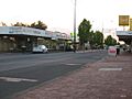
Uduc Road, Harvey, at dusk
-
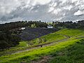
On Harvey Dam Wall. The tower is visible on the middle-right.
-
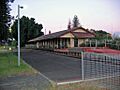
Harvey railway station
-
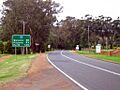
South Western Highway leaving Harvey


