Hato, San Lorenzo, Puerto Rico facts for kids
Quick facts for kids
Hato
|
|
|---|---|
|
Barrio
|
|

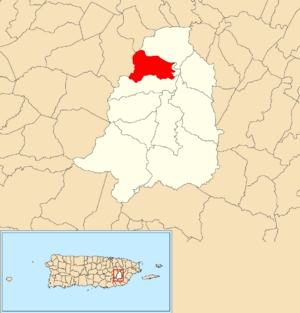
Location of Hato within the municipality of San Lorenzo shown in red
|
|
| Commonwealth | |
| Municipality | |
| Area | |
| • Total | 3.00 sq mi (7.8 km2) |
| • Land | 2.98 sq mi (7.7 km2) |
| • Water | 0.02 sq mi (0.05 km2) |
| Elevation | 699 ft (213 m) |
| Population
(2010)
|
|
| • Total | 6,945 |
| • Density | 2,330.5/sq mi (899.8/km2) |
| Source: 2010 Census | |
| Time zone | UTC−4 (AST) |
Hato is a special kind of neighborhood, called a barrio, located in the town of San Lorenzo, Puerto Rico. In 2010, about 6,945 people lived there. Hato covers an area of about 3 square miles (7.77 square kilometers).
A Look Back: Hato's History
Hato has an interesting past. After the Spanish–American War ended in 1898, Spain gave Puerto Rico to the United States. This happened under the rules of the Treaty of Paris of 1898. Puerto Rico then became a territory of the United States.
In 1899, the United States government did a count of all the people in Puerto Rico, which is called a census. This first census showed that 1,028 people lived in Hato barrio at that time. Over the years, the number of people living in Hato has changed.
| Historical population | |||
|---|---|---|---|
| Census | Pop. | %± | |
| 1900 | 1,028 | — | |
| 1980 | 3,971 | — | |
| 1990 | 6,500 | 63.7% | |
| 2000 | 7,109 | 9.4% | |
| 2010 | 6,945 | −2.3% | |
| U.S. Decennial Census 1899 (shown as 1900) 1910-1930 1930-1950 1980-2000 2010 |
|||
Understanding Hato's Sections
In Puerto Rico, barrios like Hato are often divided into even smaller areas. These smaller parts are called sectores (which means sectors in English). Think of them as smaller neighborhoods or communities within a larger barrio.
The names of these sectores can be different. Some are simply called sector, while others might be known as urbanización (a type of housing development), reparto, barriada, or residencial. Each name describes a slightly different kind of community.
Here are some of the sectores you can find within Hato barrio:
- Apartamentos Urbanización Valentina
- Camino Cholo Serrano
- Camino Esperanza Ramos
- Camino Julio Delgado
- Camino Los Claudio
- Extensión Tamarindos
- Haciendas de San Lorenzo
- Parcelas Hato
- Residencial Lorenzana
- Sector Buxó
- Sector Cáez
- Sector Capilla
- Sector Carfeli
- Sector Cuchilla
- Sector Federico Delgado
- Sector Hernández
- Sector La Loma
- Sector Los Adorno
- Sector Montañez
- Sector Muñoz
- Sector Neris
- Sector Oquendo
- Sector Rosa
- Sector Sánchez
- Sector Santiago
- Sector Solares Monzón
- Sector Zavala
- Tramo Carretera 183
- Urbanización Aponte y Sellés
- Urbanización Camino de las Flores
- Urbanización Carfeli
- Urbanización El Parque (Santa Clara)
- Urbanización Estancias de San Lorenzo (Avenida Mariano Olalla)
- Urbanización Los Caminos
- Urbanización Muñoz Marín
- Urbanización Portal del Sol
- Urbanización Ramos Antonini
- Urbanización San Lorenzo
- Urbanización San Lorenzo Valley
- Urbanización Tamarindos
- Urbanización Villas del Hato
- Urbanización Vistas de San Lorenzo
- Urbanización y Extensión Roosevelt
Explore More
 In Spanish: Hato (San Lorenzo) para niños
- List of communities in Puerto Rico
- List of barrios and sectors of San Lorenzo, Puerto Rico
 | Misty Copeland |
 | Raven Wilkinson |
 | Debra Austin |
 | Aesha Ash |


