Hato Arriba, San Sebastián, Puerto Rico facts for kids
Quick facts for kids
Hato Arriba
|
|
|---|---|
|
Barrio
|
|

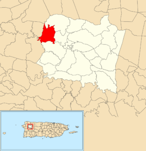
Location of Hato Arriba within the municipality of San Sebastián shown in red
|
|
| Commonwealth | |
| Municipality | |
| Area | |
| • Total | 2.96 sq mi (7.7 km2) |
| • Land | 2.96 sq mi (7.7 km2) |
| • Water | 0 sq mi (0 km2) |
| Elevation | 246 ft (75 m) |
| Population
(2010)
|
|
| • Total | 1,980 |
| • Density | 668.9/sq mi (258.3/km2) |
| Source: 2010 Census | |
| Time zone | UTC−4 (AST) |
Hato Arriba is a small community, also known as a barrio, located in the town of San Sebastián, Puerto Rico. In 2010, about 1,980 people lived there.
Contents
A Look Back in Time
Puerto Rico used to belong to Spain. After the Spanish–American War, Spain gave Puerto Rico to the United States in 1898. This happened because of a special agreement called the Treaty of Paris of 1898.
In 1899, the United States government counted everyone living in Puerto Rico. They found that Hato Arriba had a population of 663 people at that time.
| Historical population | |||
|---|---|---|---|
| Census | Pop. | %± | |
| 1900 | 663 | — | |
| 1980 | 1,467 | — | |
| 1990 | 1,728 | 17.8% | |
| 2000 | 1,991 | 15.2% | |
| 2010 | 1,980 | −0.6% | |
| U.S. Decennial Census 1899 (shown as 1900) 1910-1930 1930-1950 1980-2000 2010 |
|||
Roads and Hurricanes
Hato Arriba has two important roads: PR-111 and PR-119. These roads help people travel through the area.
Hurricane Maria's Impact
In September 2017, Hurricane Maria caused a lot of damage in Puerto Rico. A part of PR-111 in Hato Arriba was almost completely washed away by the storm.
Later, in May 2019, a lane of PR-119 collapsed. This happened because of heavy rain. The road had already been weakened by Hurricane Maria in 2017. It was on a list to be fixed, but it collapsed before repairs could be made.
Understanding Sectors
In Puerto Rico, barrios like Hato Arriba are divided into smaller areas. These smaller areas are called sectores (which means sectors in English).
There are different kinds of sectores. Some are simply called sector, while others might be named urbanización, reparto, barriada, or residencial. Each name describes a different type of local area.
Sectors in Hato Arriba
Here are some of the sectors you can find in Hato Arriba:
- Carretera 111
- Carretera 125
- Carretera 423
- Parcelas Hato Arriba
- Sector Anglada
- Sector Bernal
- Sector Campo Alegre
- Sector Caña Verde
- Sector Cuesta La Luna
- Sector Hoyo Frío
- Sector Hoyo Santo
- Sector Medina
- Sector Nando Rivera
- Sector Paseo Central
- Sector Punta Brava
- Sector Santo Torres
- Urbanización Colinas de Hato Arriba
- Urbanización Lomas Verdes
See also

- In Spanish: Hato Arriba (San Sebastián) para niños
- List of communities in Puerto Rico
- List of barrios and sectors of San Sebastián, Puerto Rico
 | Stephanie Wilson |
 | Charles Bolden |
 | Ronald McNair |
 | Frederick D. Gregory |


