Hato Puerco, Canóvanas, Puerto Rico facts for kids
Quick facts for kids
Hato Puerco
|
|
|---|---|
|
Barrio
|
|

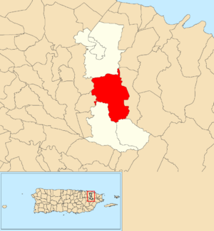
Location of Hato Puerco within the municipality of Canóvanas shown in red
|
|
| Commonwealth | |
| Municipality | |
| Area | |
| • Total | 7.96 sq mi (20.6 km2) |
| • Land | 7.96 sq mi (20.6 km2) |
| • Water | 0.00 sq mi (0 km2) |
| Elevation | 607 ft (185 m) |
| Population
(2010)
|
|
| • Total | 7,379 |
| • Density | 927/sq mi (358/km2) |
| Source: 2010 Census | |
| Time zone | UTC−4 (AST) |
Hato Puerco is a neighborhood, also called a barrio, located in the town of Canóvanas, Puerto Rico. In 2010, about 7,379 people lived there. It's a part of the beautiful island of Puerto Rico.
Contents
A Look Back: Hato Puerco's History
Puerto Rico used to belong to Spain. After the Spanish–American War in 1898, Spain gave Puerto Rico to the United States. This made Puerto Rico a U.S. territory.
In 1899, the U.S. government counted all the people living in Puerto Rico. This count is called a census. The census found that 3,139 people lived in Hato Puerco. Back then, Hato Puerco was part of the town of Loíza.
| Historical population | |||
|---|---|---|---|
| Census | Pop. | %± | |
| 1900 | 3,139 | — | |
| 1980 | 4,866 | — | |
| 1990 | 6,793 | 39.6% | |
| 2000 | 7,361 | 8.4% | |
| 2010 | 7,379 | 0.2% | |
| U.S. Decennial Census 1899 (shown as 1900) 1910-1930 1930-1950 1980-2000 2010 |
|||
Understanding Hato Puerco's Layout: Sectors
Barrios like Hato Puerco are divided into smaller areas. These smaller areas are called sectores (pronounced sek-TOH-res). You can think of them like smaller neighborhoods within a bigger one.
There are different kinds of sectores. Some are simply called sector. Others might be called urbanización (a planned housing area) or reparto (a land division).
Sectors in Campo Rico Community
The following sectores are part of the Campo Rico community within Hato Puerco:
- Camino Los Matos
- Camino Los Navarro
- Carretera 185 (Highway 185)
- Finca Pozos
- Parcelas Alturas de Campo Rico
- Parcelas Campo Rico
- Sector Belia
- Sector Canovanillas
- Sector Chorrito
- Sector El Purgatorio
- Sector Febo
- Sector La Marina
- Sector La Vega
- Sector Loma del Viento
- Sector Los González
- Sector Maga
- Sector Puente Moreno
- Sector Toma de Agua
- Urbanización Las Haciendas
Sectors in Palma Sola
The following sectores are part of Palma Sola within Hato Puerco:
- Carretera 957 (Highway 957)
- Sector El Hoyo
- Sector Los Castros
- Sector Maga
- Sector Peniel
See also
 In Spanish: Hato Puerco para niños
- List of communities in Puerto Rico
- List of barrios and sectors of Canóvanas, Puerto Rico
 | Ernest Everett Just |
 | Mary Jackson |
 | Emmett Chappelle |
 | Marie Maynard Daly |


