Palma Sola (Puerto Rico) facts for kids
Quick facts for kids
Palma Sola
|
|
|---|---|
|
Neighborhood
|
|

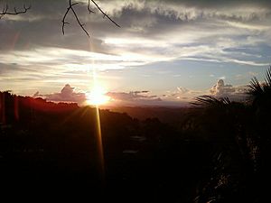
Sunset from Palma Sola
|
|
| Commonwealth | |
| Municipality | |
| Time zone | UTC−4 (AST) |
Palma Sola is a small neighborhood in Canóvanas, Puerto Rico. It is found along Puerto Rico Highway 957. This road is a smaller branch of Puerto Rico Highway 185.
Where is Palma Sola?
Palma Sola is located on the northeastern side of the island of Puerto Rico. It is part of the town of Canóvanas.
To give you an idea of its location:
- It is north of Las Piedras.
- It is south of Loíza.
- It is east of Carolina.
- It is west of Río Grande.
Palma Sola is one of several areas, or "sectors," within Canóvanas. Other sectors include Alturas, Finca Poso, Las Magas, La Central, Lomas del Viento, Cambalache, Peniel, and Sector El Hoyo.
Hurricane Maria's Impact
In September 2017, a very strong storm called Hurricane Maria hit Puerto Rico. This hurricane caused a lot of damage. In Palma Sola, the only bridge connecting the community to a main highway was destroyed. This left the people of Palma Sola cut off.
Also, all the sectors in the area lost their electricity. It took a long time for power to come back. Six months later, when the electricity was finally working again, the local church in Palma Sola showed its thanks. They held a special brunch for the workers who helped restore the power.
Other Communities in Puerto Rico
- List of communities in Puerto Rico
- List of barrios and sectors of Canóvanas, Puerto Rico
See also
 In Spanish: Palma Sola (Canóvanas) para niños
 | John T. Biggers |
 | Thomas Blackshear |
 | Mark Bradford |
 | Beverly Buchanan |


